Tutuala
 From Wikipedia the free encyclopedia
Tutuala | |
|---|---|
Suco and town | |
 Village of Tutuala | |
 Tutuala Location in East Timor | |
| Coordinates: 8°23′34.44″S 127°15′24.12″E / 8.3929000°S 127.2567000°E | |
| Country | East Timor |
| District | Lautém District |
| Subdistrict | Tutuala |
| Suco | Tutuala |
| Population (2004) | |
| • Total | 3,707 |
| Time zone | UTC+9 (East Timor Standard Time) |
| Climate | Aw |
Tutuala is a village and suco in the subdistrict of Tutuala (Lautém District, East Timor). It is situated at the extreme eastern end of Timor.[1] Its population at the 2004 census was 3,707. The subdistrict of Tutuala comprises two sucos, including Mehara and Tutuala with the subdistrict administrator residing in Tutuala. The suco of Tutuala comprised four hamlets (aldeia): Ioro, Pitileti, Tchailoro, and Vero.[2] The main Fataluku language areas of the country are in Tutuala, as well as Lautem and Fuiloro.[3]
History[edit]


In Tutuala, 24 clans or ratu have been identified.[citation needed] Tutuala were the autochthonous ratu in the village and senior people in the ratu are considered as the "Lord of the Land" (mua occawa) of the Tutuala region.[incomprehensible][5] According to local tradition, the Tutuala ratu and Kati ratu clans originally spoke the Makuva language.[citation needed] All other clans in the district originated from outside Timor, bringing their own language with them during their migration.[6] One clan has been identified as originating from southeastern Maluku.[citation needed]
Until World War II, the Lata people were settled in ancestral homes inside the forests, dependent upon the forests for their livelihoods. Many villages settled along the edges of the road or along the coast date to the period of Portuguese occupation, and after 1945 during the Indonesian occupation. Forested uplands in the Tutuala area were inhabited by the ratu or "clan groups" which included the walled and open settlements of Lata and also caves (veraka) which housed ancestral figures.[7] According to Timorese legend, Fataluku people believe that "Jaco Island (Totina), near Titula, is identified by Fatalaku people as “the head of the land”, while the rest of the island constitutions the body".[5]
Geography[edit]
Tutuala is situated at the eastern end of Timor, 31 kilometres (19 mi) northeast of Lospalos. Tutuala is bordered to the north by the Banda Sea, to the southeast by the Timor Sea and to the west by the suco of Mehara. The settlement of Muapitine is separated from Tutuala by the Vekase River.[8] The road to Tutuala passes along the northern periphery of Lake Ira Lalaro and passes through the village of Mehara where Falalaku-style houses can be seen. During the rainy season this stretch of road is prone to flooding from rising lake waters.[9]
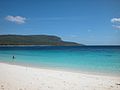
Valu Beach, which is 8 kilometres (5.0 mi) from the village, has fine white sand. Jaco Island, which also has fine beaches and is noted for its colourful anemone fish and sea turtles, is separated from Valu Beach by a narrow strait.[10]
Tutuala is situated within the Nino Konis Santana National Park. Geographic features of importance include Lake Ira Lalaro and Mount Paitchau, as well as the caves of Léné Ara, Ile Kére Kére and O Hi.[11][1]
Climate[edit]
| Climate data for Tutuala (Average monthly temperature and precipitation) | |||||||||||||
|---|---|---|---|---|---|---|---|---|---|---|---|---|---|
| Month | Jan | Feb | Mar | Apr | May | Jun | Jul | Aug | Sep | Oct | Nov | Dec | Year |
| Mean daily maximum °C (°F) | 30 (86) | 30 (86) | 31 (88) | 32 (90) | 32 (90) | 32 (90) | 32 (90) | 33 (91) | 33 (91) | 32 (90) | 31 (88) | 31 (88) | 33 (91) |
| Mean daily minimum °C (°F) | 23 (73) | 23 (73) | 23 (73) | 24 (75) | 24 (75) | 24 (75) | 24 (75) | 24 (75) | 24 (75) | 24 (75) | 24 (75) | 24 (75) | 23 (73) |
| Average precipitation mm (inches) | 511.8 (20.15) | 446.5 (17.58) | 336.3 (13.24) | 210.8 (8.30) | 238.3 (9.38) | 175.1 (6.89) | 182.9 (7.20) | 160.3 (6.31) | 170.3 (6.70) | 186.5 (7.34) | 324.7 (12.78) | 413.6 (16.28) | 3,357.1 (132.15) |
| Source: [12] | |||||||||||||
Archaeology[edit]


The caves of Ile Kére Kére were excavated in 1966–1967, and numerous items such as stone tools and the bones of giant rats were unearthed, and some of the archaeological finds in the nearby caves of Lene Hara are carbon dated to 30,000 years ago. The caves also had cave paintings. Guerrilla fighters used these caves as hiding places during wartime.[13] Excavations at the Lene Hara cave established occupation at least 30,000-35,000 years ago. Marine shells and stone artifacts have been dated to the Middle Paleolithic through Mesolithic era. The site is a raised limestone terrace situated 1 kilometre (0.62 mi) from the coast. In addition to artifact, painted rock art was also recorded at Lene Hara, in roof panels and stalagmite formations.[14] The rock shelter site, Jerimalai, also located at the tip of the island, was occupied over 42,000 years ago; inhabitants, who left behind stone tools and shells, were noted to have eaten turtles, tuna, and rats.[15]
Gallery[edit]
-
 Rice field in Mehara
 -
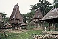 Holy houses and meeting hall in Ioro, 1970
 -
 Lake Ira Lalaro floodplain and surrounding area
 -
 View from Jaco Island


-
 Tutuala beach, in front of Jaco island
 -
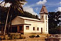 Church in Tutuala
 -
 Pousada (hotel) in Tutuala, former seat of the colonial administrator
 -
 Graffiti in Tutuala, saying "murderer" in memory of the massacre by pro-Indonesian guerrilla forces, 1999


References[edit]
- ^ a b Lonely Planet 2004, p. 81.
- ^ Jornal da Républica 2009, p. 3611.
- ^ McWilliam & Traube 2011, p. 64.
- ^ Lape 2006.
- ^ a b Miksic, Goh & O'Connor 2011, p. 42.
- ^ Sarmento 2010, p. 243.
- ^ McWilliam & Traube 2011, p. 226.
- ^ Reuter & Reuter 2006, p. 274.
- ^ Lonely Planet 2004, pp. 81–82.
- ^ Lonely Planet 2004, pp. 82–83.
- ^ European Association of Southeast Asian Archaeologists. International Conference 2006, p. 89.
- ^ Worldweather online.
- ^ Lonely Planet 2004, p. 82.
- ^ O'Connor, Spriggs & Veth 2002.
- ^ Smith 2006.
Bibliography[edit]
- European Association of Southeast Asian Archaeologists. International Conference (1 January 2006). Uncovering Southeast Asia's Past: Selected Papers from the 10th International Conference of the European Association of Southeast Asian Archaeologists : the British Museum, London, 14th-17th September 2004. NUS Press. ISBN 978-9971-69-351-0.
- Lape, Peter V. (2006). "Chronology of Fortified Settlements in East Timor" (PDF). Journal of Island & Coastal Archaeology. 1 (1): 285–297. doi:10.1080/15564890600939409. S2CID 53343024.
- "Diploma Ministerial No:199/GM/MAEOT/IX/09 de 15 de Setembro de 2009" (PDF). Jornal da Républica (in Portuguese). No. 199/09. Timor-Leste. 16 September 2009. Archived from the original (PDF) on 3 February 2010.
- Lonely Planet (2004). East Timor. Lonely Planet. ISBN 978-1-74059-644-2.
- Miksic, John N.; Goh, Geok Yian; O'Connor, Sue (2011). Rethinking Cultural Resource Management in Southeast Asia: Preservation, Development, and Neglect. Anthem Press. ISBN 978-0-85728-389-4.
- O'Connor, Sue; Spriggs, Matthew; Veth, Peter (March 2002). "Excavation at Lene Hara Cave establishes occupation in East Timor at least 30,000-35,000 years ago". Antiquity. 291. 76 (291): 47. doi:10.1017/S0003598X0008978X. S2CID 163141684.
- McWilliam, Andrew; Traube, Elizabeth G. (2011). Land and Life in Timor-Leste: Ethnographic Essays. ANU E Press. ISBN 978-1-921862-60-1.
- Reuter, Thomas; Reuter, Thomas Anton (2006). Sharing the Earth, Dividing the Land: Land and Territory in the Austronesian World. ANU E Press. ISBN 978-1-920942-70-0.
- Sarmento, Clara (1 October 2010). From here to diversity: globalization and intercultural dialogues. Cambridge Scholars. ISBN 978-1-4438-2366-1.
- Smith, Deborah (22 December 2006). "Timor cave may reveal how humans reached Australia". The Age. Retrieved 17 August 2013.
- "Tutuala Weather, Indonesia Weather Averages". Worldweather online. Retrieved 12 August 2013.