File:Fernanda 2017-07-14 2135Z.jpg


本预览的尺寸:450 × 600像素。 其他分辨率:180 × 240像素 | 360 × 480像素 | 576 × 768像素 | 768 × 1,024像素 | 1,536 × 2,048像素 | 6,300 × 8,400像素。
原始文件 (6,300 × 8,400像素,文件大小:13.46 MB,MIME类型:image/jpeg)
摘要
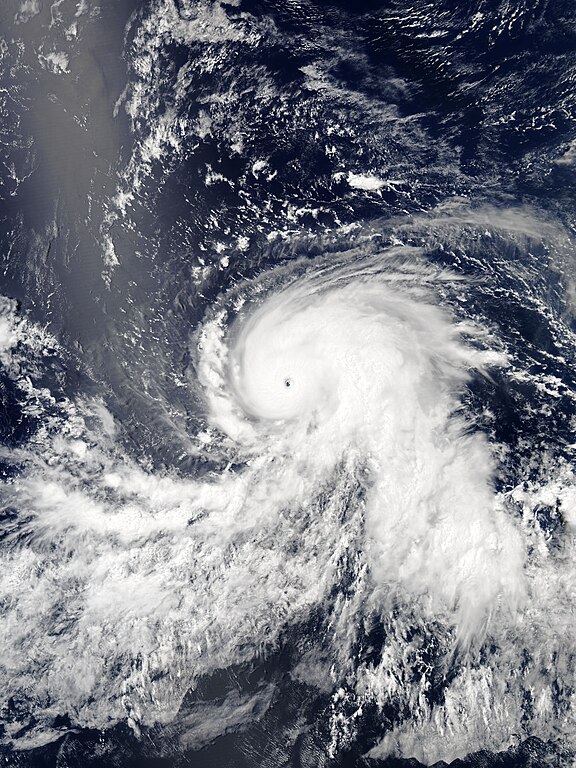
| 描述 | English: Hurricane Fernanda as a Category 4 hurricane over the Northeast Pacific Ocean late on July 14, 2017. |
| 日期 | |
| 来源 | EOSDIS Worldview |
| 作者 | MODIS image captured by NASA’s Aqua satellite |
| 相机位置 | | 在以下服务上查看本图像和附近其他图像: OpenStreetMap |
|---|
许可协议
| 本文件完全由NASA创作,在美国属于公有领域。根据NASA的版权方针,NASA的材料除非另有声明否则不受版权保护。(参见Template:PD-USGov/zh、NASA版权方针页面或JPL图片使用方针。) | ||
 | 警告:
|
文件历史
点击某个日期/时间查看对应时刻的文件。
| 日期/时间 | 缩略图 | 大小 | 用户 | 备注 | |
|---|---|---|---|---|---|
| 当前 | 2018年10月20日 (六) 07:37 | | 6,300 × 8,400(13.46 MB) | Nino Marakot | Reverted to version as of 01:50, 15 July 2017 (UTC) - looks blur due to over/under cropping. This is the original and it's pretty good |
| 2017年7月26日 (三) 10:51 |  | 5,796 × 7,757(8.59 MB) | ChocolateTrain | Storm a bit more centered with good proportions | |
| 2017年7月15日 (六) 01:50 |  | 6,300 × 8,400(13.46 MB) | Meow | Full size and optimised under the best standards. | |
| 2017年7月15日 (六) 01:30 |  | 5,200 × 6,400(14.63 MB) | TheAustinMan | User created page with UploadWizard |
文件用途
以下页面使用本文件:
全域文件用途
以下其他wiki使用此文件:
- en.wikipedia.org上的用途
- es.wikipedia.org上的用途
- fr.wikipedia.org上的用途
- ko.wikipedia.org上的用途
- pt.wikipedia.org上的用途
- vi.wikipedia.org上的用途
- www.wikidata.org上的用途