Jukhia

Jukhia | |
|---|---|
Village | |
 Jukhia Location in West Bengal, India  Jukhia Jukhia (India) | |
| Coordinates: 21°58′58″N 87°45′51″E / 21.982713°N 87.764136°E | |
| Country | |
| State | West Bengal |
| District | Purba Medinipur |
| Population (2011) | |
| • Total | 4,291 |
| Languages | |
| • Official | Bengali, English |
| Time zone | UTC+5:30 (IST) |
| PIN | 721430 |
| Telephone/STD code | 03228 |
| Lok Sabha constituency | Kanthi |
| Vidhan Sabha constituency | Bhagabanpur |
| Website | purbamedinipur |
Jukhia is a village and a gram panchayat in the Bhagabanpur II CD block in the Contai subdivision of the Purba Medinipur district in the state of West Bengal, India.
Geography[edit]

5miles
Fishing Harbour
Shankarpur
M: municipal city/ town, CT: census town, R: rural/ urban centre, H: historical/ religious centre, S: port, sea-beach
Owing to space constraints in the small map, the actual locations in a larger map may vary slightly
Location[edit]
Jukhia is located at 21°58′58″N 87°45′51″E / 21.982713°N 87.764136°E.
Urbanisation[edit]
93.55% of the population of Contai subdivision live in the rural areas. Only 6.45% of the population live in the urban areas and it is considerably behind Haldia subdivision in urbanization, where 20.81% of the population live in urban areas.[1]
Note: The map alongside presents some of the notable locations in the subdivision. All places marked in the map are linked in the larger full screen map.
Demographics[edit]
According to the 2011 Census of India, Jukhia had a total population of 4,291, of which 2,226 (52%) were males and 2,065 (48%) were females. There were 462 persons in the age range of 0–6 years. The total number of literate persons in Jukhia was 3,524 (92.03% of the population over 6 years).[2]
Education[edit]
The nearest college, Mugberia Gangadhar Mahavidyalaya at Mugberia, near Bhupatinagar was established in 1964. In addition to the courses in arts, science and commerce, it offers degree and post-graduate courses in physical education.[3][4]
Culture[edit]
David J. McCutchion mentions the Radha-Govinda temple as a West Bengal navaratna temple with turrets having curved ridging, measuring 31’ 6" square, and having been built in 1891–1901, rebuilt reincorporating terracotta carvings. The place is mentioned as Dheloa, possibly a neighbouring village with a similar name.[5]
Jukhia picture gallery[edit]
-
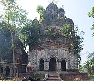 Radha Govinda temple
 -
 Decorations in Radha Govinda temple
 -
 Decorations in Radha Govinda temple
 -
 Decorations in Radha Govinda temple


Healthcare[edit]
Bhupatinagar Mugberia Rural Hospital at Bhupatinagar (with 30 beds) is the major government medical facility in Bhagabanpur II CD block.[6]
References[edit]
- ^ "District Statistical Handbook 2014 Purba Medinipur". Table 2.2. Department of Planning and Statistics, Government of West Bengal. Archived from the original on 21 January 2019. Retrieved 22 April 2019.
- ^ "CD block Wise Primary Census Abstract Data(PCA)". West Bengal – District-wise CD blocks. Registrar General and Census, India. Retrieved 16 August 2020.
- ^ "Mugberia Gangadhar Mahavidyalaya". Mugberia Gangadhar Mahavidyalaya. Archived from the original on 10 October 2016. Retrieved 10 November 2016.
- ^ "Mugberia Gangadhar Mahavidyalaya". College Admission. Retrieved 10 November 2016.
- ^ McCutchion, David J., Late Mediaeval Temples of Bengal, first published 1972, reprinted 2017, page 52. The Asiatic Society, Kolkata, ISBN 978-93-81574-65-2
- ^ "Health & Family Welfare Department". Health Statistics. Government of West Bengal. Retrieved 27 March 2019.
External links[edit]
Cities, towns, locations and neighbourhoods in Purba Medinipur District, Medinipur division | ||||||||||
|---|---|---|---|---|---|---|---|---|---|---|
| Cities, municipal and census towns |
|  | ||||||||
| Locations other than cities and towns |
| |||||||||
| Neighbourhoods |
| |||||||||
| Related topics | ||||||||||