Файл:Republic of Venice 1789.svg


Розмір цього попереднього перегляду PNG для вихідного SVG-файлу: 450 × 456 пікселів. Інші роздільності: 237 × 240 пікселів | 474 × 480 пікселів | 758 × 768 пікселів | 1011 × 1024 пікселів | 2021 × 2048 пікселів.
Повна роздільність (SVG-файл, номінально 450 × 456 пікселів, розмір файлу: 927 КБ)
| Відомості про цей файл містяться на Вікісховищі — централізованому сховищі вільних файлів мультимедіа для використання у проектах Фонду Вікімедіа. |
Опис файлу


.svg)
.svg)
.svg)
.svg)
.svg)


.svg)
.svg)
.svg)


.png)
.png)


.svg)


.svg)

.svg)


.svg)
.svg)
.svg)
.svg)


.svg)
.png)


.svg)


.svg)
.svg)


.svg)


.svg)


.svg)
.svg)
.svg)
.svg)
.svg)
.svg)
.svg)
_cropped.svg)
.svg)
.svg)
.svg)
.svg)
.svg)
.svg)
.svg)
.svg)
.svg)
.svg)
.svg)
.svg)
.svg)
.svg)
.svg)
.svg)
.svg)
.svg)
.svg)
.svg)
.svg)
.svg)
.svg)
.svg)
.svg)
.svg)
.svg)
.svg)
.svg)
.svg)
.svg)
.svg)
.svg)
.svg)
.svg)
.svg)
.svg)
.svg)
.svg)
.svg)
.svg)
.svg)
.svg)
.svg)
.svg)
Ліцензування
Я, власник авторських прав на цей твір, добровільно публікую його на умовах такої ліцензії:
Цей файл ліцензований на умовах Creative Commons Attribution-Share Alike 3.0 Unported
- Ви можете вільно:
- ділитися – копіювати, поширювати і передавати твір
- модифікувати – переробляти твір
- При дотриманні таких умов:
- зазначення авторства – Ви повинні вказати авторство, надати посилання на ліцензію і вказати, чи якісь зміни було внесено до оригінального твору. Ви можете зробити це в будь-який розсудливий спосіб, але так, щоб він жодним чином не натякав на те, наче ліцензіар підтримує Вас чи Ваш спосіб використання твору.
- поширення на тих же умовах – Якщо ви змінюєте, перетворюєте або створюєте іншу похідну роботу на основі цього твору, ви можете поширювати отриманий у результаті твір тільки на умовах такої ж або сумісної ліцензії.
Журнал завантажень локального файлу
This image is a derivative work of the following images:
- File:Europe_1789.svg licensed with Cc-by-sa-3.0
- 2013-04-14T03:44:26Z Alphathon 450x456 (858577 Bytes) Corrected some errors in northern Italy
- 2013-04-14T01:38:01Z Alphathon 450x456 (853881 Bytes) tweaked again
- 2013-04-14T01:36:10Z Alphathon 450x456 (853881 Bytes) Tweaked Holy Roman Empire border style
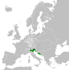
- 2013-04-14T01:33:26Z Alphathon 450x456 (853857 Bytes) == {{int:filedesc}} == {{Information |Description={{en|A blank Map of Europe circa 1789. This map also includes a border for the [[:en:Holy Roman Empire|Holy Roman Empire]]. Since there are so many small German states, they h
Uploaded with derivativeFX
Історія файлу
Клацніть на дату/час, щоб переглянути, як тоді виглядав файл.
| Дата/час | Мініатюра | Розмір об'єкта | Користувач | Коментар | |
|---|---|---|---|---|---|
| поточний | 22:20, 26 листопада 2021 | | 450 × 456 (927 КБ) | Cplakidas | Fixing Venetian Albania, adding Cythera to Venice |
| 07:55, 17 жовтня 2021 |  | 450 × 456 (803 КБ) | Fenn-O-maniC | Fixed the Russo-Swedish border to match the Treaty of Åbo of 1743 | |
| 09:23, 27 лютого 2020 |  | 450 × 456 (821 КБ) | Facquis | Clear map | |
| 17:16, 18 квітня 2013 |  | 450 × 456 (820 КБ) | Alphathon | Various fixes | |
| 03:54, 14 квітня 2013 |  | 450 × 456 (802 КБ) | Alphathon | == {{int:filedesc}} == {{Information |Description={{en|A map of the Republic of Venice circa 1789.}}{{de|Eine Landkarte die Republik Venedig c. 1989.}} |Source={{Derived from|Europe_1789.svg|display=5... |
Використання файлу
Така сторінка використовує цей файл:
Глобальне використання файлу
Цей файл використовують такі інші вікі:
- Використання в azb.wikipedia.org
- Використання в bg.wikipedia.org
- Використання в ca.wikipedia.org
- Використання в ckb.wikipedia.org
- Використання в cs.wikipedia.org
- Використання в de.wikipedia.org
- Використання в el.wikipedia.org
- Використання в en.wikipedia.org
- Використання в eu.wikipedia.org
- Використання в fa.wikipedia.org
- Використання в fy.wikipedia.org
- Використання в he.wikipedia.org
- Використання в hi.wikipedia.org
- Використання в hr.wikipedia.org
- Використання в it.wikipedia.org
- Використання в ko.wikipedia.org
- Використання в lfn.wikipedia.org
- Використання в lij.wikipedia.org
- Використання в lmo.wikipedia.org
- Використання в mk.wikipedia.org
- Використання в ml.wikipedia.org
- Використання в ms.wikipedia.org
- Використання в pl.wikipedia.org
- Використання в pt.wikipedia.org
- Використання в rue.wikipedia.org
- Використання в ru.wikipedia.org
- Використання в sk.wikipedia.org
- Використання в szl.wikipedia.org
- Використання в tr.wikipedia.org
- Використання в zh.wikipedia.org