Файл:Kuala Lumpur at dawn (18794580599).jpg


Повна роздільність (7360 × 4912 пікселів, розмір файлу: 2,33 МБ, MIME-тип: image/jpeg)
| Відомості про цей файл містяться на Вікісховищі — централізованому сховищі вільних файлів мультимедіа для використання у проектах Фонду Вікімедіа. |
.jpg)
Опис файлу
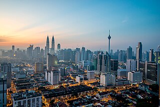
| Опис | English: Kuala Lumpur is the national capital and most populous city in Malaysia. The city covers an area of 243 km2 and has an estimated population of 1.6 million as of 2010. Greater Kuala Lumpur, covering similar area as the Klang Valley, is an urban agglomeration of 7.5 million people as of 2012. It is among the fastest growing metropolitan regions in South-East Asia, in terms of population and economy. Kuala Lumpur is the seat of the Parliament of Malaysia. The city was once home to the executive and judicial branches of the federal government, but they were moved to Putrajaya in early 1999. Some sections of the judiciary still remain in the capital city of Kuala Lumpur. The official residence of the Malaysian King, the Istana Negara, is also situated in Kuala Lumpur. Rated as an alpha world city, Kuala Lumpur is the cultural, financial and economic centre of Malaysia due to its position as the capital as well as being a key city. Kuala Lumpur was ranked 48th among global cities by Foreign Policy's 2010 Global Cities Index and was ranked 67th among global cities for economic and social innovation by the 2thinknow Innovation Cities Index in 2010. Since the 1990s, the city has played host to many international sporting, political and cultural events including the 1998 Commonwealth Games and the Formula One Grand Prix. In addition, Kuala Lumpur is home to the tallest twin buildings in the world, the Petronas Twin Towers, which have become an iconic symbol of Malaysia's futuristic development [Wikipedia.org] |
| Час створення | |
| Джерело | Kuala Lumpur at dawn |
| Автор | Jorge Láscar from Melbourne, Australia |
| Місцеположення камери | | Перегляньте це та інші зображення поблизу на: OpenStreetMap |
|---|
.jpg¶ms=003.156242_N_0101.713056_E_globe:Earth_type:camera_source:Flickr_&language=uk)
Ліцензування
- Ви можете вільно:
- ділитися – копіювати, поширювати і передавати твір
- модифікувати – переробляти твір
- При дотриманні таких умов:
- зазначення авторства – Ви повинні вказати авторство, надати посилання на ліцензію і вказати, чи якісь зміни було внесено до оригінального твору. Ви можете зробити це в будь-який розсудливий спосіб, але так, щоб він жодним чином не натякав на те, наче ліцензіар підтримує Вас чи Ваш спосіб використання твору.
| Це зображення початково було завантажене користувачем Jorge Lascar на Flickr за посиланням https://flickr.com/photos/8721758@N06/18794580599. 2 лютого 2018 його переглянув робот FlickreviewR 2 і підтвердив, що зображення ліцензоване згідно з умовами cc-by-2.0. |
Історія файлу
Клацніть на дату/час, щоб переглянути, як тоді виглядав файл.
| Дата/час | Мініатюра | Розмір об'єкта | Користувач | Коментар | |
|---|---|---|---|---|---|
| поточний | 10:28, 2 лютого 2018 | | 7360 × 4912 (2,33 МБ) | Thesupermat2 | Transferred from Flickr via Flickr2Commons |
Використання файлу
Такі сторінки використовують цей файл:
Глобальне використання файлу
Цей файл використовують такі інші вікі:
- Використання в bn.wikipedia.org
- Використання в bo.wikipedia.org
- Використання в en.wikipedia.org
- Kuala Lumpur
- Kajang
- Demographics of Malaysia
- Geography of Malaysia
- Shah Alam
- George Town, Penang
- List of cities in Malaysia
- Ipoh
- Kota Kinabalu
- Johor Bahru
- Klang (city)
- Kuantan
- Petaling Jaya
- Sungai Petani
- Alor Setar
- Subang Jaya
- Malacca City
- Tawau
- Seberang Perai
- Iskandar Puteri
- Malaysia
- Lists of cities by country
- Ampang Jaya
- Portal:Malaysia/Topics
- Selayang
- Template:Largest cities of Malaysia
- Seremban
- User:Joothis
- List of megalopolises
- Використання в fr.wikipedia.org
- Використання в hu.wikipedia.org
- Використання в id.wikipedia.org
- Використання в io.wikipedia.org
- Використання в ml.wikipedia.org
- Використання в no.wikipedia.org
- Використання в ta.wikipedia.org
- Використання в th.wikipedia.org
Переглянути сторінку глобального використання цього файлу.
.jpg)
.jpg)