Dosya:Carte du Conseil de l'Europe.png
 Vikipedi, özgür ansiklopedi
Bu önizlemenin boyutu: 784 × 600 piksel. Diğer çözünürlükler: 314 × 240 piksel | 628 × 480 piksel | 1.004 × 768 piksel | 1.200 × 918 piksel.
Tam çözünürlük ((1.200 × 918 piksel, dosya boyutu: 284 KB, MIME tipi: image/png))
Bu dosya Wikimedia Commons'ta bulunmaktadır. Dosyanın açıklaması aşağıda gösterilmiştir. Commons, serbest/özgür telifli medya dosyalarının bulundurulduğu depodur. Siz de yardım edebilirsiniz. |
 | File:Map of Council of Europe member states by founding and later members.svg, bu dosyanın vektör versiyonudur. Aşağı olmadığında bu raster görüntünün yerine kullanılmalıdır. File:Carte du Conseil de l'Europe.png → File:Map of Council of Europe member states by founding and later members.svg Daha fazla bilgi için Help:SVG/tr sayfasına bakın. |  |
Özet
| Açıklama | |
| Tarih | |
| Kaynak | Own work by uploader, based on Image:Euro 2008.png |
| Yazar | JLogan |
Lisanslama
Ben, bu işin telif sahibi, burada işi aşağıdaki lisanslar altında yayımlıyorum:
Bu dosya, Creative Commons Atıf-Benzer Paylaşım 3.0 Taşınmamış lisansı ile lisanslanmıştır
- Şu seçeneklerde özgürsünüz:
- paylaşım – eser paylaşımı, dağıtımı ve iletimi
- içeriği değiştirip uyarlama – eser adaptasyonu
- Aşağıdaki koşullar geçerli olacaktır:
- atıf – Esere yazar veya lisans sahibi tarafından belirtilen (ancak sizi ya da eseri kullanımınızı desteklediklerini ileri sürmeyecek bir) şekilde atıfta bulunmalısınız.
- benzer paylaşım – Maddeyi yeniden karıştırır, dönüştürür veya inşa ederseniz, katkılarınızı orijinal olarak aynı veya uyumlu lisans altında dağıtmanız gerekir.
 | Bu belgenin GNU Özgür Belgeleme Lisansı, Sürüm 1.2 veya Özgür Yazılım Vakfı tarafından yayımlanan sonraki herhangi bir sürüm şartları altında bu belgenin kopyalanması, dağıtılması ve/veya değiştirilmesi için izin verilmiştir; Değişmeyen Bölümler, Ön Kapak Metinleri ve Arka Kapak Metinleri yoktur. Lisansın bir kopyası GNU Özgür Belgeleme Lisansı sayfasında yer almaktadır. |
İstediğiniz lisansı seçebilirsiniz.
Dosya geçmişi
Dosyanın herhangi bir zamandaki hâli için ilgili tarih/saat kısmına tıklayın.
| Tarih/Saat | Küçük resim | Boyutlar | Kullanıcı | Yorum | |
|---|---|---|---|---|---|
| güncel | 17.50, 11 Mart 2022 | | 1.200 × 918 (284 KB) | Sbb1413 | Update. |
| 13.19, 1 Ekim 2020 |  | 1.200 × 1.000 (38 KB) | Super Dromaeosaurus | Added Isle of Man, Guernsey and Jersey | |
| 04.49, 6 Ocak 2015 |  | 1.200 × 1.000 (52 KB) | Jurryaany | Fixed German sovereignty over Borkum. | |
| 03.52, 14 Kasım 2013 |  | 1.200 × 1.000 (48 KB) | Che829 | Reverted to version as of 21:36, 19 August 2008 - Nonfactual unsupported claim as per official documents published by CoE (Founders are only the 10 original signatories of w:Treaty of London (1949) on 5 May 1949 at St. James's Palace in London http... | |
| 21.27, 13 Şubat 2009 |  | 1.200 × 1.000 (43 KB) | Emturan | Greece and Turkey are striped to show their founder member status while they joined to Council of Europe later. | |
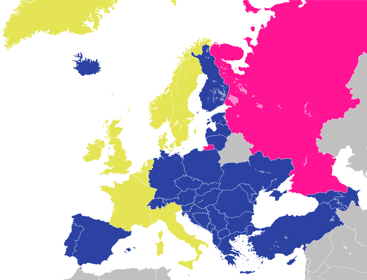
| 21.36, 19 Ağustos 2008 |  | 1.200 × 1.000 (48 KB) | JLogan | {{Information |Description={{en|1=Map of the Council of Europe.<br />{{legend|#e4e454|Founder}}{{legend|#2b42a3|Later member}}}} {{fr|1=Carte du Conseil de l'Europe.<br />{{legend|#e4e454|Fondateurs}}{{legend|#2b42a3|Autres}}}} | |
Dosya kullanımı
Bu görüntü dosyasına bağlanan sayfa yok.
Küresel dosya kullanımı
Aşağıdaki diğer vikiler bu dosyayı kullanır:
- en.wikipedia.org üzerinde kullanımı
- fr.wikipedia.org üzerinde kullanımı
- hy.wikipedia.org üzerinde kullanımı
- ja.wikipedia.org üzerinde kullanımı
- ru.wikipedia.org üzerinde kullanımı