Nîmes

Nimes | |
|---|---|
Prefecture and commune | |
 | |
.svg) Coat of arms | |
Location of Nimes  | |
 Nimes  Nimes | |
| Coordinates: 43°30′06″N 4°12′50″E / 43.5016°N 4.2139°E | |
| Country | France |
| Region | Occitanie |
| Department | Gard |
| Arrondissement | Nimes |
| Intercommunality | Communauté d'agglomération Nîmes Métropole |
| Government | |
| • Mayor (2014-2020) | Jean-Paul Fournier |
| Area 1 | 164.2 km2 (63.4 sq mi) |
| Population (2012) | 146,709 |
| • Density | 890/km2 (2,300/sq mi) |
| Time zone | UTC+01:00 (CET) |
| • Summer (DST) | UTC+02:00 (CEST) |
| INSEE/Postal code | 30189 /30000 |
| Elevation | 21–215 m (69–705 ft) (avg. 39 m or 128 ft) |
| 1 French Land Register data, which excludes lakes, ponds, glaciers > 1 km2 (0.386 sq mi or 247 acres) and river estuaries. | |
Nîmes is a commune. It is the prefecture of the Gard department in the Languedoc-Roussillon region. Nîmes dates back to Ancient Rome.
History[change | change source]
Nîmes was an important Roman town. Many sites have been discovered, including:
- The temple of Diane
- The Maison Carrée
- The Nîmes amphitheatre, the best-preserved in France.
The town was supplied with water by the Pont du Gard.
Sister cities[change | change source]
Nîmes is twinned with:
 Preston, United Kingdom, since 1955.
 Verona, Italy, since 1960.
 Braunschweig, Germany, since 1962.
 Prague, Czech Republic, since 1967.
- Frankfurt an der Oder, Germany, since 1976.
 Salamanca, Spain, since 1979.
 Rishon LeZion, Israel, since 1986.
 Meknes, Morocco, since 2005.
-
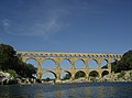 Pont du Gard
 -
 Maison Carrée
 -
 Temple of Diane
 -
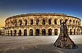 Nîmes amphitheatre

.jpg)


| International | |
|---|---|
| National | |
| Geographic | |
| Other | |