Chhattisgarh

Chhattisgarh | |
|---|---|
State of India | |
 Location of Chhattisgarh in India | |
 Map of Chhattisgarh | |
| Coordinates: 21°16′N 81°36′E / 21.27°N 81.6°E | |
| Country | |
| Region | East India |
| Area | |
| • Total | 135,192 km2 (52,198 sq mi) |
| Population (2011) | |
| • Total | 25,545,198[1] |
| Time zone | UTC+05:30 (IST) |
Chhattisgarh is a state within the Republic of India. It occupies 52,199 square miles (135,190 km2). In traditional Indian geography it falls under the East Indian zone.
The capital at present is Raipur which would change to 'Naya Raipur' near Raipur. It has eighteen districts: Raigarh, Bilaspur, Bijapur, Korba, Durg, Janjgir, Raipur, Koria, Sarguja, Bastar, Dantewada, Narayanpur, Rajnandgaon, Kanker, Mahasamund, Dhamtari, Jashpur and Kabirdham (Kawardha). The main languages spoken are Hindi and Chhattisgarhi. The main religion is Hindu.
Provincial symbols of Chhattisgarh[change | change source]
-
 Provincial bird of Chhattisgarh
 -
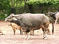 Provincial animal of Chhattisgarh
 -
 Provincial tree of Chhattisgarh


-_flowering_canopy_W_Picture_117.jpg)
References[change | change source]
- ↑ "Chhattisgarh Population 2011 - 2022". www.census2011.co.in. Retrieved 2022-03-06.
Wikimedia Commons has media related to Chhattisgarh.
| States | Andhra Pradesh • Arunachal Pradesh • Assam • Bihar • Chhattisgarh • Goa • Gujarat • Haryana • Himachal Pradesh • Jharkhand • Karnataka • Kerala • Madhya Pradesh • Maharashtra • Manipur • Meghalaya • Mizoram • Nagaland • Odisha • Punjab • Rajasthan • Sikkim • Tamil Nadu • Telangana • Tripura • Uttar Pradesh • Uttarakhand • West Bengal | |
|---|---|---|
| Union Territories | ||