Файл:Australian desert ESA345627.jpg
 Из Википедии, бесплатной энциклопедии

Исходный файл (1680 × 1920 пкс, размер файла: 4,7 Мб, MIME-тип: image/jpeg)
Этот файл находится на Викискладе. Сведения о нём показаны ниже. Викисклад — централизованное хранилище для свободных файлов, используемых в проектах Викимедиа. |
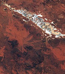
Краткое описание
| Описание | English: This spectacular image captured by Sentinel-2A on 13 July features Lake Amadeus, in Australia’s Northern Territory. It shows the variety of the sandy, rocky and salty formations within the lake. Around 180 km long and 10 km wide, Amadeus is the largest salt lake in the Northern Territory, just 50 km north of Uluru/ Ayers Rock. Lake Amadeus contains up to 600 million tonnes of salt. However, harvesting is not feasible because of its remote location. Owing to the aridity of the area, the surface of Lake Amadeus is often a dry salt crust. When rainfall is sufficient, it becomes part of an east-flowing drainage system that eventually connects to the Finke River. A UNESCO World Heritage Site and one of Australia’s most recognisable landmarks, Uluru/Ayers Rock is a large sandstone rock formation standing 348 m high, rising 863 m above sea level and with a circumference of 9.4 km. Also clearly visible in the lower-central part of the image are the Petermann Ranges. These mountains run 320 km across the border between Western Australia and the southwest corner of the Northern Territory. Their highest point is 1158 m above sea level. The range was formed about 550 million years ago as compression folded a section of Earth’s crust. Launched in June, Sentinel-2A – the most recent satellite in orbit for Europe’s Copernicus programme – provides detailed information about Earth’s land cover and inland water bodies, helping us to understand Earth’s varied landscape. This image is also featured on the Earth from Space video programme. |
| Дата | |
| Источник | http://www.esa.int/spaceinimages/Images/2015/09/Australian_desert |
| Автор | European Space Agency |
| Права (Повторное использование этого файла) | Copernicus Sentinel data (2015)/ESA,CC BY-SA 3.0 IGO |
| Title | Australian desert |
| Set | Earth observation image of the week |
| System | Copernicus |
| Mission | Sentinel-2 |
| Location | Australia |
| Activity | Observing the Earth |
| Keywords | Deserts; Lakes; Satellite image |
| Местоположение объекта | | Это и другие изображения по их местоположению на OpenStreetMap |
|---|

Лицензирование
- Вы можете свободно:
- делиться произведением – копировать, распространять и передавать данное произведение
- создавать производные – переделывать данное произведение
- При соблюдении следующих условий:
- атрибуция – Вы должны указать авторство, предоставить ссылку на лицензию и указать, внёс ли автор какие-либо изменения. Это можно сделать любым разумным способом, но не создавая впечатление, что лицензиат поддерживает вас или использование вами данного произведения.
- распространение на тех же условиях – Если вы изменяете, преобразуете или создаёте иное произведение на основе данного, то обязаны использовать лицензию исходного произведения или лицензию, совместимую с исходной.
| Аннотации | Это изображение аннотировано: Просмотреть аннотации на Викискладе |
История файла
Нажмите на дату/время, чтобы посмотреть файл, который был загружен в тот момент.
| Дата/время | Миниатюра | Размеры | Участник | Примечание | |
|---|---|---|---|---|---|
| текущий | 16:16, 6 мая 2017 | | 1680 × 1920 (4,7 Мб) | Fæ | == {{int:filedesc}} == {{information | description = {{en|1=This spectacular image captured by Sentinel-2A on 13 July features Lake Amadeus, in Australia’s Northern Territory. It shows the variety of the sandy, rocky and salty formations within the l... |
Использование файла
Следующая страница использует этот файл: