Bestand:UAEOMCmap.png

Grootte van deze voorvertoning: 671 × 599 pixels. Andere resoluties: 269 × 240 pixels | 537 × 480 pixels | 928 × 829 pixels.
Oorspronkelijk bestand (928 × 829 pixels, bestandsgrootte: 39 kB, MIME-type: image/png)
| Dit is een bestand van Wikimedia Commons. Onderstaande beschrijving komt van de beschrijving van het bestand daar. |
Beschrijving
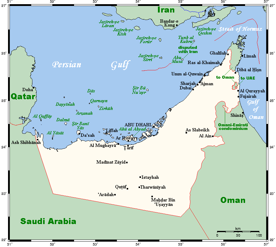
| Beschrijving | English: A map showing the UAE's cities and main towns, along with nearby areas. This map's source is here, with the uploader's modifications, and the GMT homepage says that the tools are released under the GNU General Public License. |
| Datum | 20 juli 2007 (originele uploaddatum) |
| Bron | Verplaatst vanaf en.wikipedia naar Commons door Georgez. |
| Auteur | Kelisi op de Engelstalige Wikipedia |
| Andere versies | العربيَّة |
Licentie
Kelisi uit en.wikipedia.org, de auteursrechthebbende van dit werk, maakt het hierbij onder de volgende licentie beschikbaar:
| Dit bestand is gelicenseerd onder de Creative Commons-licentie Naamsvermelding-Gelijk delen 3.0 Unported Onderhevig aan disclaimers. | ||
| Naamsvermelding: Kelisi uit en.wikipedia.org | ||
| ||
| Deze licentietag is toegevoegd aan dit bestand in verband met de GFDL licentie-update. |
 | Toestemming wordt verleend voor het kopiëren, verspreiden en/of wijzigen van dit document onder de voorwaarden van de GNU-licentie voor vrije documentatie, versie 1.2 of enige latere versie als gepubliceerd door de Free Software Foundation; zonder Invariant Sections, zonder Front-Cover Texts, en zonder Back-Cover Texts. Een kopie van de licentie is opgenomen in de sectie GNU-licentie voor vrije documentatie. Onderhevig aan disclaimers. |
Oorspronkelijk uploadlogboek
De oorspronkelijke beschrijving van deze afbeelding stond hier. Alle volgende gebruikersnamen verwijzen naar en.wikipedia.
- 2007-07-20 01:00 Kelisi 928×829× (31672 bytes) == Summary == A map showing the UAE's cities and main towns, along with nearby areas. This map's source is [http://www.aquarius.ifm-geomar.de/ here], with the uploader's modifications, and the [http://gmt.soest.hawaii.edu/ GMT homepage] says that the tool
Bestandsgeschiedenis
Klik op een datum/tijd om het bestand te zien zoals het destijds was.
| Datum/tijd | Miniatuur | Afmetingen | Gebruiker | Opmerking | |
|---|---|---|---|---|---|
| huidige versie | 30 jan 2021 19:54 | | 928 × 829 (39 kB) | Kelisi | The Saudi-Qatari border has been adjusted to reflect what current maps generally show. Source was Open Street Map, which I always find to be the trustworthiest in such matters (and, of course, the freest as well; so there is no copyright to worry about). |
| 25 mrt 2009 17:55 |  | 928 × 829 (31 kB) | Georgez | {{Information |Description={{en|A map showing the UAE's cities and main towns, along with nearby areas. This map's source is [http://www.aquarius.ifm-geomar.de/ here], with the uploader's modifications, and the [http://gmt.soest.hawaii.edu/ GMT homepage] |
Bestandsgebruik
Dit bestand wordt op de volgende pagina gebruikt:
Globaal bestandsgebruik
De volgende andere wiki's gebruiken dit bestand:
- Gebruikt op ar.wikipedia.org
- Gebruikt op ca.wikipedia.org
- Gebruikt op ckb.wikipedia.org
- Gebruikt op en.wikipedia.org
- Gebruikt op eo.wikipedia.org
- Gebruikt op es.wikipedia.org
- Gebruikt op fa.wikipedia.org
- Gebruikt op fr.wikipedia.org
- Gebruikt op hr.wikipedia.org
- Gebruikt op id.wikipedia.org
- Gebruikt op it.wikipedia.org
- Gebruikt op ja.wikipedia.org
- Gebruikt op nn.wikipedia.org