Bestand:India population density map en.svg


Oorspronkelijk bestand (SVG-bestand, nominaal 1.639 × 1.852 pixels, bestandsgrootte: 1,23 MB)
| Dit is een bestand van Wikimedia Commons. Onderstaande beschrijving komt van de beschrijving van het bestand daar. |
| Titel | India population density map (english) | |||||||||
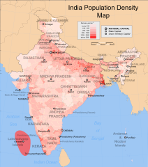
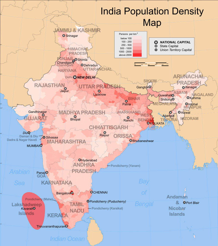
| Beschrijving | Map showing the population density of each district in India. Based on 2001 census. | |||||||||
| Map legend |  | |||||||||
| Datum | ||||||||||
| Bron | Eigen werk | |||||||||
| Maker |
| |||||||||
| Toestemming (Hergebruik van dit bestand) | Ik, de auteursrechthebbende van dit werk, maak het hierbij onder de volgende licentie beschikbaar: Dit bestand is gelicenseerd onder de Creative Commons-licentie Naamsvermelding-Gelijk delen 3.0 Unported
| |||||||||
| Geotemporal data | ||||||||||
| Weergegeven datum | tweede helft 20e eeuw en 21e eeuw | |||||||||
| Geodetisch coördinatensysteem | conic | |||||||||
| Bounding box |
| |||||||||
| Georeferencing | If inappropriate please set warp_status = skip to hide. | |||||||||
| Archival data | ||||||||||
| Opmerkingen | Part of WikiProject India Maps | |||||||||

Notes
Depiction of India's borders
- The territorial boundaries of India are shown as per the actual ground situation in accordance with international practices followed by the United Nations ([1], [2]) and the National Geographic Society ([3], [4])
- This map is meant to be for illustrative purpose only and is not authenticated by official government sources. Please check the list of sources and references used to create the map for a measure of accuracy and verifiability.
- The usage of these maps in India, Pakistan and China are governed by different laws that restrict depictions of boundaries other than what is officially recognized by the state. Please check local laws and modify the map accordingly before use.
Explanation of disputed boundaries


- Boundary of Indian claim : The territory India claims is legally theirs, but the claim is disputed by China and Pakistan.
- Line of Control/Line of Conflict : The de facto administrative boundary recognised by the international community. This UN ceasefire line is considered as a temporary solution to an ongoing conflict since the departure of the British Raj.
Borders of disputed regions
The depicted extent of the former territory of the British Indian Empire, succeeded by Republic of India, may not be accepted by few countries as legal due to ongoing border disputes:
- The northern Himalayan region of the disputed territory Indian-administered Kashmir is claimed by India including (Pakistan-administered Kashmir) and the Chinese-occupied territory of (Ladakh plateau). Since 1972, it is divided between all three countries. See also Line of Control and Line of Actual Control.
- Siachen glacier (shown white) is an actively contested region between India and Pakistan. Since 1984, the region is under Indian control.
- The northeastern territory of Arunachal Pradesh is almost entirely claimed by China as part of its Tibetan territory.
- Minor areas of eastern Kashmir's Ladakh division, Himachal Pradesh and Uttarakhand on the Chinese frontier are claimed by China. These areas are under Indian control.
- A small area of Uttarakhand adjoining the Nepal border along the Sarda river is disputed between the two countries.
For a detailed map of all disputed regions in South Asia, see Image:India disputed areas map.svg
Internal borders
The borders of the state of Meghalaya, Assam and Arunachal Pradesh are shown as interpreted from the North-Eastern Areas (Reorganisation) Act, 1971, but has yet to be verified.
Territorial waters
The limit of the territorial waters of India extends to twelve nautical miles measured from the appropriate baseline. See this for more information.
derivative works
Afgeleide werken van dit bestand:
Bestandsgeschiedenis
Klik op een datum/tijd om het bestand te zien zoals het destijds was.
| Datum/tijd | Miniatuur | Afmetingen | Gebruiker | Opmerking | |
|---|---|---|---|---|---|
| huidige versie | 24 aug 2009 05:12 | | 1.639 × 1.852 (1,23 MB) | Quibik | Made SVG valid. Converted text to paths for correct display. |
| 27 nov 2008 05:33 |  | 1.639 × 1.852 (873 kB) | Indianhilbilly | Reverted to version as of 10:10, 18 October 2006, readded original map so that the thumbnail is informative | |
| 25 nov 2008 18:00 |  | 1.639 × 1.852 (1,16 MB) | Planemad | added cities and corrected errors | |
| 18 okt 2006 12:10 |  | 1.639 × 1.852 (873 kB) | Planemad | {{WikiProject_India_Maps |Title=India population density map (english) |Description=Map showing the population density of each district in India. Based on 2001 census. |Source=India Map site[http://www.censusindiamaps.net Census] - [http://www.censusindia |
Bestandsgebruik
Geen enkele pagina gebruikt dit bestand.
Globaal bestandsgebruik
De volgende andere wiki's gebruiken dit bestand:
- Gebruikt op ar.wikipedia.org
- Gebruikt op be.wikipedia.org
- Gebruikt op bg.wikipedia.org
- Gebruikt op bn.wikipedia.org
- Gebruikt op ca.wikipedia.org
- Gebruikt op ce.wikipedia.org
- Gebruikt op cs.wikipedia.org
- Gebruikt op dv.wikipedia.org
- Gebruikt op dz.wikipedia.org
- Gebruikt op el.wikipedia.org
- Gebruikt op en.wikipedia.org
- List of states and union territories of India by population
- Talk:India/Archive 4
- Portal:India/Selected picture candidates/Archived nominations
- Talk:India/Archive 11
- Portal:India/Selected picture candidates/India population density map
- Talk:India/Demographics
- List of states in India by past population
- Registrar General and Census Commissioner of India
- Template:Portal/doc/all
- Wikipedia:Userboxes/WikiProjects/Cities
- Wikipedia:WikiProject India/Templates
- Gebruikt op es.wikipedia.org
- Gebruikt op fi.wikipedia.org
- Gebruikt op fr.wikipedia.org
- Gebruikt op fy.wikipedia.org
- Gebruikt op ga.wikipedia.org
- Gebruikt op gl.wikipedia.org
- Gebruikt op he.wikipedia.org
- Gebruikt op hi.wikipedia.org
- Gebruikt op hu.wikipedia.org
- Gebruikt op hy.wikipedia.org
- Gebruikt op io.wikipedia.org
- Gebruikt op ka.wikipedia.org
- Gebruikt op kk.wikipedia.org
- Gebruikt op kn.wikipedia.org
- Gebruikt op lv.wikipedia.org
- Gebruikt op mn.wikipedia.org
- Gebruikt op mr.wikipedia.org
- Gebruikt op nds-nl.wikipedia.org
- Gebruikt op nn.wikipedia.org
- Gebruikt op no.wikipedia.org
- Gebruikt op pl.wikipedia.org
Globaal gebruik van dit bestand bekijken.