Smoković

Smoković | |
|---|---|
Village | |
 Church of St. George after the war | |
 Smoković Location of Smoković in Croatia | |
| Coordinates: 44°08′04″N 15°21′11″E / 44.13444°N 15.35306°E | |
| Country | |
| Region | Adriatic Croatia |
| County | Zadar |
| Municipality | Zemunik Donji |
| Area | |
| • Total | 16.9 km2 (6.5 sq mi) |
| Elevation | 93 m (305 ft) |
| Population (2021)[2] | |
| • Total | 165 |
| • Density | 9.8/km2 (25/sq mi) |
| Time zone | UTC+1 (CET) |
| • Summer (DST) | UTC+2 (CEST) |
| Postal code | 23 222 Zemunik Donji |
| Area code | (+385) 23 |
Smoković is a village in Croatia, in the municipality of Zemunik Donji, Zadar County.
Demographics[edit]
According to the 2011 census,[3] the village of Smoković has 110 inhabitants. This represents 10.69% of its pre-war population according to the 1991 census.
The 1991 census[4] recorded that 96.12% of the village population were ethnic Serbs (989/1029), 1.26% were Yugoslavs (13/1029), 1.26% were ethnic Croats (13/1029), and 1.36% were of other ethnic origin (14/1029).
Sources: Croatian Bureau of Statistics
Gallery[edit]
-
 Church of St. George before the 1991-1995 war
 -
 Church of St. George demolished (1993)
 -
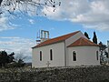 Church of St. George reconstructed


See also[edit]
References[edit]
- ^ Register of spatial units of the State Geodetic Administration of the Republic of Croatia. Wikidata Q119585703.
- ^ "Population by Age and Sex, by Settlements" (xlsx). Census of Population, Households and Dwellings in 2021. Zagreb: Croatian Bureau of Statistics. 2022.
- ^ a b "Population by Age and Sex, by Settlements, 2011 Census: Smoković". Census of Population, Households and Dwellings 2011. Zagreb: Croatian Bureau of Statistics. December 2012.
- ^ Izdanje Državnog zavoda za statistiku RH: Narodnosni sastav stanovništva RH od 1880-1991. godine.
- ^ Naselja i stanovništvo Republike Hrvatske 1857-2001, www.dzs.hr
- ^ "Croats Battle Serbs for a Key Bridge Near the Adriatic". New York Times. January 24, 1993. Retrieved January 21, 2019.
44°08′04″N 15°21′11″E / 44.13444°N 15.35306°E
This Zadar County geography article is a stub. You can help Wikipedia by expanding it. |