ファイル:World 1914 empires colonies territory.PNG
 ウィキペディアから無料の百科事典

このプレビューのサイズ: 800 × 330 ピクセル。 その他の解像度: 320 × 132 ピクセル | 640 × 264 ピクセル | 1,522 × 628 ピクセル。
元のファイル (1,522 × 628 ピクセル、ファイルサイズ: 45キロバイト、MIME タイプ: image/png)
ウィキメディア・コモンズのファイルページにある説明を、以下に表示します。 |
 | この地図画像は、ベクターイメージである SVG ファイルとして再作成されるべきです。これにはいくつかの利点があります。詳しくはCommons:Media for cleanupを参照してください。この画像の SVG 形式がすでに利用可能である場合は、アップロードしてください。アップロード後、この画像にあるこのテンプレートを{{Vector version available|新しい画像ファイル名.svg}}テンプレートで置き換えてください。 |
概要
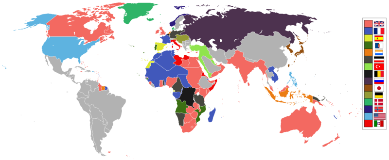
| 解説 | English: World empires and colonies in 1914, just before the First World War.
| ||||||||||||||||
| 日付 | |||||||||||||||||
| 原典 | 投稿者自身による著作物 | ||||||||||||||||
| 作者 | Andrew0921 | ||||||||||||||||
.jpg)
._LOC_2001620596.jpg)
British Empire
France
Spain
Portugal
Netherlands
German Empire
Ottoman
Belgium
Russia
Japan
Denmark
Norway
United States of America
Italy
Independent/other countries
ライセンス
この作品の著作権者である私は、この作品を以下のライセンスで提供します。
このファイルはクリエイティブ・コモンズ 表示 3.0 非移植ライセンスのもとに利用を許諾されています。
- あなたは以下の条件に従う場合に限り、自由に
- 共有 – 本作品を複製、頒布、展示、実演できます。
- 再構成 – 二次的著作物を作成できます。
- あなたの従うべき条件は以下の通りです。
- 表示 – あなたは適切なクレジットを表示し、ライセンスへのリンクを提供し、変更があったらその旨を示さなければなりません。これらは合理的であればどのような方法で行っても構いませんが、許諾者があなたやあなたの利用行為を支持していると示唆するような方法は除きます。
ファイルの履歴
過去の版のファイルを表示するには、その版の日時をクリックしてください。
| 日付と時刻 | サムネイル | 寸法 | 利用者 | コメント | |
|---|---|---|---|---|---|
| 現在の版 | 2021年11月8日 (月) 09:28 | | 1,522 × 628 (45キロバイト) | Randomastwritter | jubaland |
| 2021年4月14日 (水) 00:00 |  | 1,522 × 628 (45キロバイト) | Offa29 | Fixed Togoland colour | |
| 2020年4月24日 (金) 18:57 |  | 1,522 × 628 (45キロバイト) | The- | Norwegian flag | |
| 2020年4月24日 (金) 17:08 |  | 1,522 × 628 (45キロバイト) | The- | If an old map with wrongly drawn borders is replaced with a better map wth a minor colour error, then fix that minor colour error. Don't just blithely revert to the bad old map. | |
| 2020年3月17日 (火) 21:52 |  | 1,474 × 620 (36キロバイト) | Makkkkus | Replaced the Swedish-Norwegian union flag with the Norwegian flag. | |
| 2020年3月13日 (金) 19:25 |  | 1,474 × 620 (22キロバイト) | Morris-frank | The new version introduced a big regression (coloring spain in the color of italy), also it did not contribute anything useful. | |
| 2019年8月14日 (水) 21:49 |  | 1,522 × 628 (45キロバイト) | The- | More accurate map | |
| 2016年7月5日 (火) 12:47 |  | 1,474 × 620 (22キロバイト) | Maproom | Removed borders between provinces of Australia, as requested at https://en.wikipedia.org/wiki/Wikipedia:Graphics_Lab/Map_workshop#FIFA_World_Cup_Maps_-_Colonial_Boundaries , because it had been united into a single dominion before 1914. | |
| 2010年12月26日 (日) 00:00 |  | 1,474 × 620 (33キロバイト) | Quigley | by 1914, Qing Dynasty had collapsed and Republic of China established | |
| 2010年11月22日 (月) 13:56 |  | 1,474 × 620 (20キロバイト) | AnonMoos | cropping margins, increasing PNG compression |
ファイルの使用状況
グローバルなファイル使用状況
以下に挙げる他のウィキがこの画像を使っています:
- af.wikipedia.org での使用状況
- ar.wikipedia.org での使用状況
- azb.wikipedia.org での使用状況
- bn.wikipedia.org での使用状況
- ca.wikipedia.org での使用状況
- da.wikipedia.org での使用状況
- en.wikipedia.org での使用状況
- eo.wikipedia.org での使用状況
- eo.wikiquote.org での使用状況
- es.wikipedia.org での使用状況
- fa.wikipedia.org での使用状況
- fi.wikipedia.org での使用状況
- fr.wikipedia.org での使用状況
- fy.wikipedia.org での使用状況
- gl.wikipedia.org での使用状況
- hu.wikipedia.org での使用状況
- it.wikipedia.org での使用状況
- jv.wikipedia.org での使用状況
- ka.wikipedia.org での使用状況
- lv.wikipedia.org での使用状況
- mk.wikipedia.org での使用状況
- ml.wikipedia.org での使用状況
- oc.wikipedia.org での使用状況
- pt.wikipedia.org での使用状況
- ta.wikipedia.org での使用状況
- te.wikipedia.org での使用状況
- th.wikipedia.org での使用状況
- www.wikidata.org での使用状況
このファイルのグローバル使用状況を表示する。