ファイル:Enceladus PIA06191.jpg
 ウィキペディアから無料の百科事典

元のファイル (3,750 × 2,876 ピクセル、ファイルサイズ: 1.05メガバイト、MIME タイプ: image/jpeg)
ウィキメディア・コモンズのファイルページにある説明を、以下に表示します。 |
概要
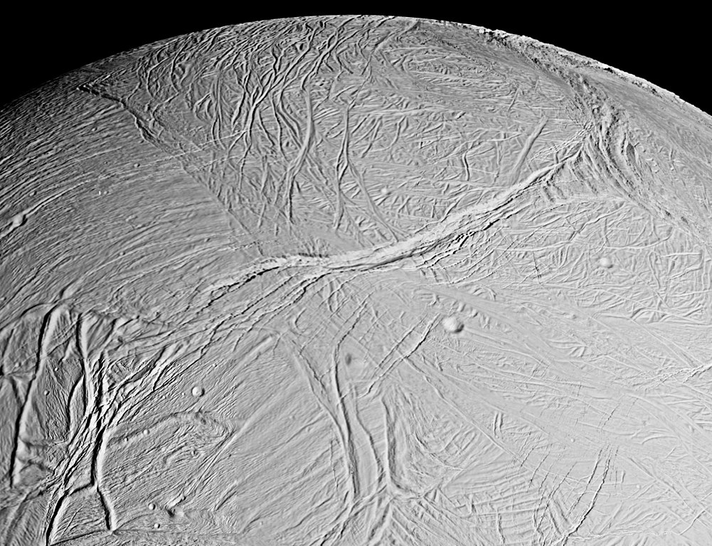
| 解説 | English: This spectacular view is a mosaic of four high resolution images taken by the Cassini spacecraft narrow angle camera on Feb. 16, 2005, during its close flyby of Saturn's moon Enceladus. The view is about 300 kilometers (200 miles) across and shows the myriad of faults, fractures, folds, troughs and craters that make this Saturnian satellite especially intriguing to planetary scientists. More than 20 years ago, NASA's Voyager spacecraft gave hints of a surface cut by tectonic features, and subsequent images of other icy moons have revealed many different ways that stresses have acted on icy moon crusts. The new close-up images of Enceladus, which has a diameter of 505 kilometers (314 miles), show some familiar-looking features and others that are brand new. The work required to unravel their origins, their formation sequence, and the implications for the evolution of icy solar system bodies is just beginning. Voyager images of Enceladus, which were obtained at much poorer spatial resolution, showed terrains like those seen here. They were called "smooth plains" because they appeared to exhibit little topographic relief. However, Cassini has now viewed these terrains at almost 10 times better resolution. The new images reveal very complex systems of fractures, resurfaced terrain, and in some cases, topographic relief greater than several hundred meters. Many styles of fracturing are evident in this mosaic. Extending downward from the top center of the mosaic for hundreds of kilometers is a broad belt of complex, interwoven fractures. A huge rift 5 kilometers (3 miles)-wide dissects this belt and extends into several older-looking, distinct regions or "cells" of terrain that themselves exhibit distinct fracture patterns. Because Cassini flew rapidly past Enceladus, the right-side images were taken from a slightly different perspective than the left, and are delineated by the white box. The mosaic covers longitudes from about 254 west to 296 west and latitudes from 60 south to the equator. The images were taken in visible light on Feb. 17, 2005, at distances ranging from of 26,140 to 17,434 kilometers (16,243 to 10,833 miles) from Enceladus and at Sun-Enceladus-spacecraft, or phase, angles ranging from 27 to 29 degrees. Pixel scale in the left-side image is 150 meters (492 feet) per pixel; in the right-side (white box) image, scale is 105 meters (344 feet) per pixel. The image has been contrast-enhanced to aid visibility. |
| 日付 | |
| 原典 | http://photojournal.jpl.nasa.gov/catalog/PIA06191 |
| 作者 | NASA/JPL/Space Science Institute |
| このタグは、添付された著作物の著作権状況を示すものではありません。通常の著作権タグも必要です。Commons:ライセンシングもご覧ください。 他言語での翻訳:
|
ライセンス
| このファイルはアメリカ航空宇宙局(NASA)によって作成されたものです。NASAの著作権の方針では、特記事項が無い場合、NASAの資料はパブリックドメインとなります。 (詳しくはTemplate:PD-USGov、NASAの著作権の方針について(英語)又はジェット推進研究所(JPL)の画像使用に関するガイドライン(英語)をご覧ください。) | ||
 | 注意事項:
|
ファイルの履歴
過去の版のファイルを表示するには、その版の日時をクリックしてください。
| 日付と時刻 | サムネイル | 寸法 | 利用者 | コメント | |
|---|---|---|---|---|---|
| 現在の版 | 2016年4月1日 (金) 22:54 | | 3,750 × 2,876 (1.05メガバイト) | Banjo | better res |
| 2005年2月20日 (日) 15:50 |  | 2,340 × 1,580 (623キロバイト) | Bricktop | Enceladus image from NASA |
ファイルの使用状況
以下のページがこのファイルを使用しています:
グローバルなファイル使用状況
以下に挙げる他のウィキがこの画像を使っています:
- ar.wikipedia.org での使用状況
- cs.wikipedia.org での使用状況
- da.wikipedia.org での使用状況
- de.wikipedia.org での使用状況
- en.wikipedia.org での使用状況
- en.wikinews.org での使用状況
- et.wikipedia.org での使用状況
- eu.wikipedia.org での使用状況
- gl.wikipedia.org での使用状況
- he.wikipedia.org での使用状況
- io.wikipedia.org での使用状況
- it.wikipedia.org での使用状況
- lb.wikipedia.org での使用状況
- nl.wikipedia.org での使用状況
- pl.wikipedia.org での使用状況
- ro.wikipedia.org での使用状況
- ru.wikipedia.org での使用状況
- srn.wikipedia.org での使用状況
- sv.wikinews.org での使用状況
- uk.wikipedia.org での使用状況
- uz.wikipedia.org での使用状況
- www.wikidata.org での使用状況
- zh.wikipedia.org での使用状況