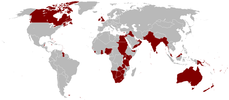
ファイル:British Empire 1921.png
 ウィキペディアから無料の百科事典

元のファイル (1,425 × 625 ピクセル、ファイルサイズ: 58キロバイト、MIME タイプ: image/png)
ファイルの履歴
過去の版のファイルを表示するには、その版の日時をクリックしてください。
| 日付と時刻 | サムネイル | 寸法 | 利用者 | コメント | |
|---|---|---|---|---|---|
| 現在の版 | 2023年10月7日 (土) 03:14 |  | 1,425 × 625 (58キロバイト) | Alanzx123 | added weihaiwei |
| 2023年7月25日 (火) 11:45 |  | 1,425 × 625 (40キロバイト) | Przemko1 | Bhutan, Sikkim british protectorates | |
| 2021年10月31日 (日) 08:02 |  | 1,425 × 625 (40キロバイト) | Randomastwritter | juba | |
| 2019年3月14日 (木) 22:05 |  | 1,425 × 625 (56キロバイト) | Horserice | Fixed Hong Kong. | |
| 2017年6月5日 (月) 16:27 |  | 1,425 × 625 (31キロバイト) | Maproom | Altered borders between Egypt, Libya and Sudan to agree with File:BlankMap-World-1921.png, which supposedly shows the correct borders as at 1921. | |
| 2015年12月11日 (金) 19:44 |  | 1,425 × 625 (32キロバイト) | Braganza | Tibet existed until 1949 | |
| 2015年9月3日 (木) 19:35 |  | 1,425 × 625 (35キロバイト) | फ़िलप्रो | Fixed Nepal, Sikkim, and Bhutan. They were de facto princely states / protectorates of the British Empire. | |
| 2015年3月26日 (木) 21:02 |  | 1,425 × 625 (39キロバイト) | David C. S. | Ecudor in 1921 | |
| 2011年5月7日 (土) 19:00 |  | 1,425 × 625 (49キロバイト) | Quigley | Correct China's borders closer to what was internationally recognized at the time | |
| 2010年10月13日 (水) 01:33 |  | 1,425 × 625 (50キロバイト) | Vadac | Uploaded a clearer version with traditional British colour, added critical islands in Pacific and Caribbean and fixed the boarders of countries at the time such as Tuva among others |
ファイルの使用状況
以下の 5 ページがこのファイルを使用しています:
グローバルなファイル使用状況
以下に挙げる他のウィキがこの画像を使っています:
- af.wikipedia.org での使用状況
- als.wikipedia.org での使用状況
- am.wikipedia.org での使用状況
- ar.wikipedia.org での使用状況
- ast.wikipedia.org での使用状況
- azb.wikipedia.org での使用状況
- az.wikipedia.org での使用状況
- bg.wikipedia.org での使用状況
- bn.wikipedia.org での使用状況
- br.wikipedia.org での使用状況
- ca.wikipedia.org での使用状況
- cs.wikipedia.org での使用状況
- da.wikipedia.org での使用状況
- de.wikipedia.org での使用状況
- el.wikipedia.org での使用状況
- en.wikipedia.org での使用状況
このファイルのグローバル使用状況を表示する。
