ファイル:Yungay Viejo - location of landslide 1970.jpg


このプレビューのサイズ: 800 × 166 ピクセル。 その他の解像度: 320 × 66 ピクセル | 640 × 133 ピクセル | 1,024 × 213 ピクセル | 1,280 × 266 ピクセル | 4,992 × 1,037 ピクセル。
元のファイル (4,992 × 1,037 ピクセル、ファイルサイズ: 1.71メガバイト、MIME タイプ: image/jpeg)
ウィキメディア・コモンズのファイルページにある説明を、以下に表示します。 |
概要
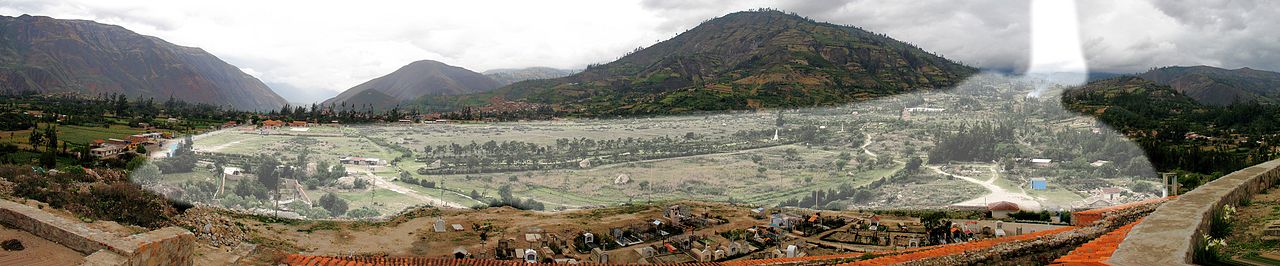
| 解説 | English: Yungay Viejo (2500 m) as seen from the cemetery hill. The light shaded area shows the location of the landslide (ice, mud, debris avalanche) on 31.05.1970, caused by an earthquake, in which a part of the western flank of Huascaran Norte broke (6652 m). Yungay Nuevo is behind the shaded area in the center. Deutsch: Yungay Viejo (2500 m) vom Friedhofshügel aus gesehen. Die hell markierte Fläche zeigt die Lage des Erdrutsches (Eis-, Schlamm-, Gerölllawine) vom 31.05.1970, verursacht durch ein Erdbeben, bei dem ein Teil der Westflanke des Huascaran Norte (6652 m) abbrach. Yungay Nuevo liegt hinter der markierten Fläche in Bildmitte. Español: Yungay Viejo (2500 m), visto desde la colina del cementerio. El área sombreada muestra la ubicación del deslizamiento (hielo, barro, una avalancha de escombros) el 31.05.1970, causada por un terremoto, en el que una parte del flanco occidental del Huascarán Norte rompió (6652 m). Yungay Nuevo está detrás de la zona sombreada en el centro. |
| 日付 | 09.01.2008 |
| 原典 | 投稿者自身による著作物 |
| 作者 | Uwebart |
ライセンス
この作品の著作権者である私は、この作品を以下のライセンスで提供します。
 | この文書は、フリーソフトウェア財団発行のGNUフリー文書利用許諾書 (GNU Free Documentation License) 1.2またはそれ以降のバージョンの規約に基づき、複製や再配布、改変が許可されます。不可変更部分、表紙、背表紙はありません。このライセンスの複製は、GNUフリー文書利用許諾書という章に含まれています。 |
- あなたは以下の条件に従う場合に限り、自由に
- 共有 – 本作品を複製、頒布、展示、実演できます。
- 再構成 – 二次的著作物を作成できます。
- あなたの従うべき条件は以下の通りです。
- 表示 – あなたは適切なクレジットを表示し、ライセンスへのリンクを提供し、変更があったらその旨を示さなければなりません。これらは合理的であればどのような方法で行っても構いませんが、許諾者があなたやあなたの利用行為を支持していると示唆するような方法は除きます。
- 継承 – もしあなたがこの作品をリミックスしたり、改変したり、加工した場合には、あなたはあなたの貢献部分を元の作品とこれと同一または互換性があるライセンスの下に頒布しなければなりません。
あなたは上記のライセンスから、どれか一つ以上を選択できます。
ファイルの履歴
過去の版のファイルを表示するには、その版の日時をクリックしてください。
| 日付と時刻 | サムネイル | 寸法 | 利用者 | コメント | |
|---|---|---|---|---|---|
| 現在の版 | 2013年2月27日 (水) 05:05 | 4,992 × 1,037 (1.71メガバイト) | Uwebart | {{Information |Description ={{en|1=Yungay Viejo (2500 m) as seen from the cemetery hill. The light shaded area shows the location of the landslide (ice, mud, debris avalanche) on 31.05.1970, caused by an earthquake, in which a part of the western fl... |
ファイルの使用状況
グローバルなファイル使用状況
以下に挙げる他のウィキがこの画像を使っています:
- de.wikipedia.org での使用状況
- en.wikipedia.org での使用状況
- es.wikipedia.org での使用状況
- fr.wikipedia.org での使用状況
- it.wikipedia.org での使用状況