ファイル:The Diomede Islands in the BeringSea (picture from space).jpg

このプレビューのサイズ: 750 × 600 ピクセル。 その他の解像度: 300 × 240 ピクセル | 600 × 480 ピクセル | 900 × 720 ピクセル。
元のファイル (900 × 720 ピクセル、ファイルサイズ: 66キロバイト、MIME タイプ: image/jpeg)
ウィキメディア・コモンズのファイルページにある説明を、以下に表示します。 |
.jpg?uselang=ja)
.jpg?uselang=ja)
.jpg?uselang=ja&action=history)
.jpg)
概要
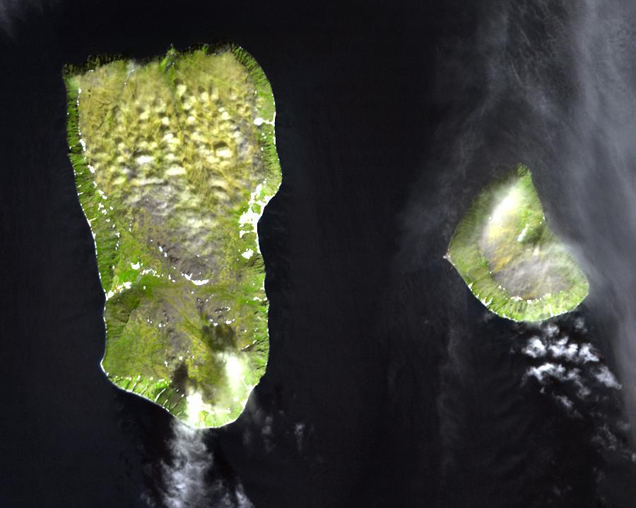
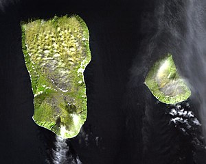
| 解説 | English: Diomede Islands in the middle of the Bering Strait:. The islands are separated by the border between Russia and the USA and by the International Date Line.
|
| 日付 | |
| 原典 |
|
| 作者 | 不明 |
| 許可 (ファイルの再利用) | This file is in the public domain because it was created by NASA. NASA copyright policy states that "NASA material is not protected by copyright unless noted". (NASA copyright policy page or JPL Image Use Policy). This image does not contain a NASA logo. |
ライセンス
| このファイルはアメリカ航空宇宙局(NASA)によって作成されたものです。NASAの著作権の方針では、特記事項が無い場合、NASAの資料はパブリックドメインとなります。 (詳しくはTemplate:PD-USGov、NASAの著作権の方針について(英語)又はジェット推進研究所(JPL)の画像使用に関するガイドライン(英語)をご覧ください。) | ||
 | 注意事項:
|
ファイルの履歴
過去の版のファイルを表示するには、その版の日時をクリックしてください。
| 日付と時刻 | サムネイル | 寸法 | 利用者 | コメント | |
|---|---|---|---|---|---|
| 現在の版 | 2008年8月11日 (月) 05:25 | | 900 × 720 (66キロバイト) | Micov | {{Information |Description={{en|1=The boarder between the USSR and the USA in the cold war. }} |Source=This file is in the public domain because it was created by NASA. NASA copyright policy stat |
ファイルの使用状況
以下の 2 ページがこのファイルを使用しています:
グローバルなファイル使用状況
以下に挙げる他のウィキがこの画像を使っています:
- af.wikipedia.org での使用状況
- ar.wikipedia.org での使用状況
- ast.wikipedia.org での使用状況
- az.wikipedia.org での使用状況
- be.wikipedia.org での使用状況
- ca.wikipedia.org での使用状況
- da.wikipedia.org での使用状況
- de.wikipedia.org での使用状況
- en.wikipedia.org での使用状況
- es.wikipedia.org での使用状況
- fi.wikipedia.org での使用状況
- fr.wikipedia.org での使用状況
- fr.wiktionary.org での使用状況
- he.wikipedia.org での使用状況
- hy.wikipedia.org での使用状況
- id.wikipedia.org での使用状況
- it.wikipedia.org での使用状況
- mk.wikipedia.org での使用状況
- nl.wikipedia.org での使用状況
- pl.wikipedia.org での使用状況
- ru.wikipedia.org での使用状況
- simple.wikipedia.org での使用状況
- sv.wikipedia.org での使用状況
- tr.wikipedia.org での使用状況
- vi.wikipedia.org での使用状況
- www.wikidata.org での使用状況
- zh.wikipedia.org での使用状況
.jpg)