ファイル:Pre-eruption Pinatubo.jpg


Pre-eruption_Pinatubo.jpg (500 × 334 ピクセル、ファイルサイズ: 69キロバイト、MIME タイプ: image/jpeg)
ウィキメディア・コモンズのファイルページにある説明を、以下に表示します。 |
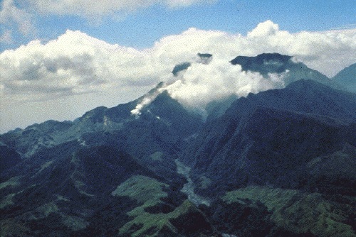
| 解説 | Mount Pinatubo in April 1991, before the onset of magmatic eruptions. Preeruption Mount Pinatubo, April 16, 1991. View from the northwest, up the Maraunot River valley. The river had become acidic and silty, owing to reactivation of the hydrothermal system and phreatic explosions of April 2, 1991 (the vents of which were just out of view at left edge of photograph). Steam was from 2-week-old fumaroles on the upper north slope of the volcano. The fumarole farthest to the right (behind a jagged ridge, right of the one visible on the valley floor) would later become the site of the preclimactic lava dome extrusion of June 7-12 (Hoblitt, Wolfe, and others, this volume). Mount Negron is behind and to the right of Pinatubo. (R.S. Punongbayan) |
| 日付 | |
| 原典 | Figure 2A on Photographic Record of Rapid Geomorphic Change at Mount Pinatubo, 1991-94 |
| 作者 | United States Geological Survey |
この画像およびメディアは、アメリカ合衆国内務省の実務機関であるアメリカ地質調査所に属する者が職務上作成した著作物のみで構成されているため、アメリカ合衆国国内でパブリックドメインの状態にあります。詳細についてはUSGSの著作物に関する取扱い(英語)をご覧ください。
|
ファイルの履歴
過去の版のファイルを表示するには、その版の日時をクリックしてください。
| 日付と時刻 | サムネイル | 寸法 | 利用者 | コメント | |
|---|---|---|---|---|---|
| 現在の版 | 2005年10月12日 (水) 18:57 | | 500 × 334 (69キロバイト) | Ascánder | Mount Pinatubo in April 1991, before the onset of magmatic eruptions. (Probable) source: [http://pubs.usgs.gov/pinatubo/punong1/fig2a.jpg Fig.2A] on [http://pubs.usgs.gov/pinatubo/punong1/index.html] {{PD-USGov-Interior-USGS}} [[Category:Philippines] |
ファイルの使用状況
以下のページがこのファイルを使用しています:
グローバルなファイル使用状況
以下に挙げる他のウィキがこの画像を使っています:
- az.wikipedia.org での使用状況
- bg.wikipedia.org での使用状況
- cs.wikipedia.org での使用状況
- en.wikipedia.org での使用状況
- es.wikipedia.org での使用状況
- fi.wikipedia.org での使用状況
- fr.wikipedia.org での使用状況
- he.wikipedia.org での使用状況
- hy.wikipedia.org での使用状況
- io.wikipedia.org での使用状況
- it.wikipedia.org での使用状況
- ka.wikipedia.org での使用状況
- kk.wikipedia.org での使用状況
- lt.wikipedia.org での使用状況
- nl.wikipedia.org での使用状況
- no.wikipedia.org での使用状況
- pam.wikipedia.org での使用状況
- pl.wikipedia.org での使用状況
- ru.wikipedia.org での使用状況
- sk.wikipedia.org での使用状況
- sr.wikipedia.org での使用状況