ファイル:PonticKingdom.png


このプレビューのサイズ: 718 × 600 ピクセル。 その他の解像度: 287 × 240 ピクセル | 575 × 480 ピクセル | 919 × 768 ピクセル | 1,226 × 1,024 ピクセル | 1,551 × 1,296 ピクセル。
元のファイル (1,551 × 1,296 ピクセル、ファイルサイズ: 265キロバイト、MIME タイプ: image/png)
ウィキメディア・コモンズのファイルページにある説明を、以下に表示します。 |
 | このhistorical map画像は、ベクターイメージである SVG ファイルとして再作成されるべきです。これにはいくつかの利点があります。詳しくはCommons:Media for cleanupを参照してください。この画像の SVG 形式がすでに利用可能である場合は、アップロードしてください。アップロード後、この画像にあるこのテンプレートを{{Vector version available|新しい画像ファイル名.svg}}テンプレートで置き換えてください。 |
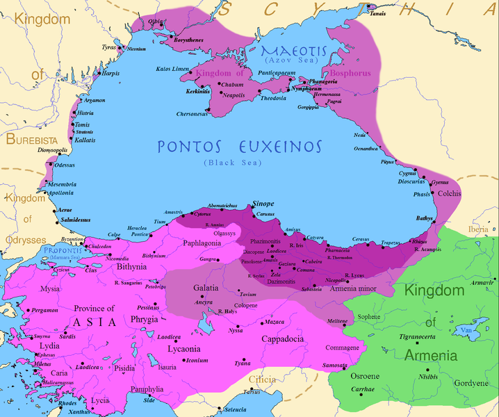
| 解説 | English: Map of the Kingdom of Pontus, Before the reign of Mithridates VI (darkest purple), after his conquests (purple), and his conquests in the first Mithridatic wars (pink); little adds (ancient shorelines & some greek colonies under Mithridate's rule) according with V. Yanko-Hombach, A.S. Gilbert, N. Panin, P. M. Dolukhanov: The Black Sea Flood Question: Changes in Coastline, Climate, and Human Settlement, Springer, Netherlands, 2007, and with Appianus, Plutarchus & Strabo. |
| 日付 | |
| 原典 | I (Javierfv1212 (talk)) created this work entirely by myself. Sources, Cambridge Ancient history volume 9, Penguin atlas of Greek history and the Foreign Policy of Mithridates VI Eupator. |
| 作者 | Javierfv1212 (talk) |
ライセンス
| この著作物は、著作者である英語版ウィキペディアのJavierfv1212さんによって権利が放棄され、パブリックドメインとされました。これは全世界で適用されます。 一部の国では、これが法的に可能ではない場合があります。その場合は、次のように宣言します。 Javierfv1212は、あらゆる人に対して、法により必要とされている条件を除き、如何なる条件も課すことなく、あらゆる目的のためにこの著作物を使用する権利を与えます。 |
元のアップロードログ
en.wikipedia からコモンズに Falcorian によって CommonsHelper を用いて移動されました。
元のファイルページはこちら。以下の利用者は全てen.wikipediaに属します。
- 2009-07-19 23:42 Javierfv1212 1551×1296× (205182 bytes) {{Information |Description = Map of the Kingdom of Pontus, Before the reign of mithridates VI (darkest purple), after his conquests (purple), and his conquests in the first Mithridatic wars (pink). |Source = I (~~~) created this work entirel
ファイルの履歴
過去の版のファイルを表示するには、その版の日時をクリックしてください。
| 日付と時刻 | サムネイル | 寸法 | 利用者 | コメント | |
|---|---|---|---|---|---|
| 現在の版 | 2017年12月9日 (土) 02:00 | | 1,551 × 1,296 (265キロバイト) | SteinsplitterBot | Bot: Image rotated by 90° |
| 2017年12月9日 (土) 00:00 |  | 1,296 × 1,551 (316キロバイト) | SteinsplitterBot | Bot: Image rotated by 270° | |
| 2016年9月22日 (木) 17:54 |  | 1,551 × 1,296 (265キロバイト) | Hohum | Lighten water area | |
| 2016年8月9日 (火) 11:21 |  | 1,551 × 1,296 (260キロバイト) | MAXHO | Details : more cities & shoreline of this time | |
| 2015年10月1日 (木) 20:57 |  | 1,551 × 1,296 (249キロバイト) | Spiridon Ion Cepleanu | Cosmetic again | |
| 2015年9月30日 (水) 12:55 |  | 1,551 × 1,296 (247キロバイト) | Spiridon Ion Cepleanu | Cosmetic colours & background names | |
| 2014年4月7日 (月) 14:21 |  | 1,551 × 1,296 (225キロバイト) | Spiridon Ion Cepleanu | Little changes (ancient shoreline & some greek colonies under Pontic rule) according with V. Yanko-Hombach, A.S. Gilbert, N. Panin, P. M. Dolukhanov: ''The Black Sea Flood Question: Changes in Coastline, Climate, and Human Settlement'', Springer, Nethe... | |
| 2009年7月20日 (月) 04:14 |  | 1,551 × 1,296 (200キロバイト) | File Upload Bot (Magnus Manske) | {{BotMoveToCommons|en.wikipedia|year={{subst:CURRENTYEAR}}|month={{subst:CURRENTMONTHNAME}}|day={{subst:CURRENTDAY}}}} {{Information |Description={{en|Map of the Kingdom of Pontus, Before the reign of mithridates VI (darkest purple), after his conquests |
ファイルの使用状況
以下の 4 ページがこのファイルを使用しています:
グローバルなファイル使用状況
以下に挙げる他のウィキがこの画像を使っています:
- ar.wikipedia.org での使用状況
- ast.wikipedia.org での使用状況
- azb.wikipedia.org での使用状況
- az.wikipedia.org での使用状況
- bg.wikipedia.org での使用状況
- br.wikipedia.org での使用状況
- ca.wikipedia.org での使用状況
- cs.wikipedia.org での使用状況
- da.wikipedia.org での使用状況
- de.wikipedia.org での使用状況
- el.wikipedia.org での使用状況
- en.wikipedia.org での使用状況
- es.wikipedia.org での使用状況
- et.wikipedia.org での使用状況
- eu.wikipedia.org での使用状況
- fa.wikipedia.org での使用状況
- fr.wikipedia.org での使用状況
このファイルのグローバル使用状況を表示する。