ファイル:October Snow in Colorado.jpg


このプレビューのサイズ: 763 × 600 ピクセル。 その他の解像度: 306 × 240 ピクセル | 611 × 480 ピクセル | 978 × 768 ピクセル | 1,280 × 1,006 ピクセル | 2,560 × 2,011 ピクセル | 5,600 × 4,400 ピクセル。
元のファイル (5,600 × 4,400 ピクセル、ファイルサイズ: 4.7メガバイト、MIME タイプ: image/jpeg)
ウィキメディア・コモンズのファイルページにある説明を、以下に表示します。 |
概要
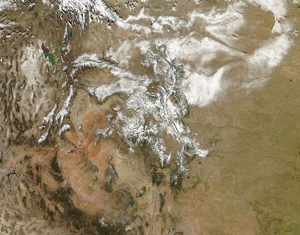
| 解説 | English: Snow highlights the rugged mountains as well as the urban and agricultural landscapes of the plains. During this event, winds were predominantly from the north. Air moving southward from the Wyoming-Colorado border blew down-slope toward the South Platte River Valley, and it dropped less snow. On the far side of the river, however, the terrain rises and as the air climbed up-slope, heavier snow fell. The difference in snow totals occurs because air that is descending generally warms and dries. Air that is forced to rise over elevated topography cools, and more water vapour condenses into rain or snow. This pattern of heavy snow in up-slope (north-facing) areas and less in down-slope areas is repeated across the state, most obviously in river valleys oriented in an east-west direction, including the Gunnison and Rio Grande Valleys in Colorado and the Green River Valley in Utah. |
| 日付 | |
| 原典 | NASA Earth Observatory |
| 作者 | Jeff Schmaltz |
Image captured by the Moderate Resolution Imaging Spectroradiometer (MODIS) on NASA’s Aqua satellite. Image courtesy of the MODIS Rapid Response Team at NASA GSFC.
ライセンス
| このファイルはアメリカ航空宇宙局(NASA)によって作成されたものです。NASAの著作権の方針では、特記事項が無い場合、NASAの資料はパブリックドメインとなります。 (詳しくはTemplate:PD-USGov、NASAの著作権の方針について(英語)又はジェット推進研究所(JPL)の画像使用に関するガイドライン(英語)をご覧ください。) | ||
 | 注意事項:
|
| 注釈 | この画像には注釈がついています: コモンズで注釈を見る |
ファイルの履歴
過去の版のファイルを表示するには、その版の日時をクリックしてください。
| 日付と時刻 | サムネイル | 寸法 | 利用者 | コメント | |
|---|---|---|---|---|---|
| 現在の版 | 2009年11月4日 (水) 12:25 | | 5,600 × 4,400 (4.7メガバイト) | Originalwana | {{Information |Description={{en|1=Snow highlights the rugged mountains as well as the urban and agricultural landscapes of the plains. During this event, winds were predominantly from the north. Air moving southward from the Wyoming- |
ファイルの使用状況
以下のページがこのファイルを使用しています: