ファイル:North America second level political division 2.svg

元のファイル(SVG ファイル、512 × 596 ピクセル、ファイルサイズ: 132キロバイト)

概要

解説
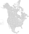
English: Map of North America and its second-level political divisions. Canadian provinces, US and Mexican states. Canada, Mexico, United States.

Non-contiguous parts of a states/provinces are "grouped" together with the main area of the state/provinces, so any state/provinces can be coloured in completion with one click anywhere on the state/provinces's area.

Also, all states/provinces have a "id" attached to them, making them easy to find. Select "find" and then enter in the state/provinces's ISO 3166-2 code in the "id" field to find it. The codes can be found here (Canada), here (USA) and here (Mexico).
日付
原典

Canada and US map: BlankMap-USA-states-Canada-provinces, HI closer.svg by Lokal_Profil.
Mexico map: Mexico template.svg by Mario Fuente Cid
Combined by Alex Covarrubias.

 
このSVGのソースコードは正しい.
 
このベクターイメージInkscape で作成され、テキストエディタで編集されました
 
W3C-validity not checked.
作者 Alex Covarrubias
許可
(ファイルの再利用)
w:ja:クリエイティブ・コモンズ
表示 継承
このファイルはクリエイティブ・コモンズ 表示-継承 2.5 一般ライセンスのもとに利用を許諾されています。
あなたは以下の条件に従う場合に限り、自由に
  • 共有 – 本作品を複製、頒布、展示、実演できます。
  • 再構成 – 二次的著作物を作成できます。
あなたの従うべき条件は以下の通りです。
  • 表示 – あなたは適切なクレジットを表示し、ライセンスへのリンクを提供し、変更があったらその旨を示さなければなりません。これらは合理的であればどのような方法で行っても構いませんが、許諾者があなたやあなたの利用行為を支持していると示唆するような方法は除きます。
  • 継承 – もしあなたがこの作品をリミックスしたり、改変したり、加工した場合には、あなたはあなたの貢献部分を元の作品とこれと同一または互換性があるライセンスの下に頒布しなければなりません。
その他のバージョン

このファイルの派生的著作物:

キャプション

このファイルの内容を1行で記述してください

このファイルに描写されている項目

題材

7 10 2007

ファイルの履歴

過去の版のファイルを表示するには、その版の日時をクリックしてください。

日付と時刻サムネイル寸法利用者コメント
現在の版2020年11月23日 (月) 01:512020年11月23日 (月) 01:51時点における版のサムネイル512 × 596 (132キロバイト)Ponderosapine210Added the prominent islands of Manitoulin (Ontario) and Isle Royale (Michigan) to the Great Lakes.
2019年6月1日 (土) 23:072019年6月1日 (土) 23:07時点における版のサムネイル512 × 596 (130キロバイト)Fluffy89502added territories, made DC visible, adjusted mexican borders
2014年4月4日 (金) 12:232014年4月4日 (金) 12:23時点における版のサムネイル1,712 × 1,992 (270キロバイト)Lommesmade the borders between the mexican subdivisions the same size as their canadian / us counterparts.
2007年12月8日 (土) 23:232007年12月8日 (土) 23:23時点における版のサムネイル1,712 × 1,992 (327キロバイト)Lokal ProfilCode cleanup
2007年10月7日 (日) 07:552007年10月7日 (日) 07:55時点における版のサムネイル1,712 × 1,992 (342キロバイト)AlexCovarrubias== Summary == {{Information |Description=Map of North America and its second-level political divisions. Canadian provinces, US and Mexican states. Canada, Mexico, United States. |Source=Canada and US map by Alan Rockefeller. Mexico map by Alex Covarrubias

このファイルを使用しているページはありません。

グローバルなファイル使用状況

メタデータ