ファイル:Map-Germany-1945.svg

元のファイル(SVG ファイル、3,492 × 2,966 ピクセル、ファイルサイズ: 726キロバイト)

概要

解説
العربية: حدود المناطق المحتلة في ألمانيا عام 1957. الاراضي شرق خط نيس تحت السيطرة البولندية والسوفييتية، تظهر بلون ابيض. برلين منطقة مسيطر عليها من عدة بلدان داخل المنطقة السوفييتة.
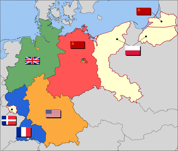
English: Occupation zone borders in Germany, 1947. The territories east of the Oder-Neisse line, under Polish and Soviet administration/annexation, are shown as cream as is the likewise detached Saar protectorate. Berlin is the multinational area within the Soviet zone.
Français : Carte des zones d'occupation de l'Allemagne : le protectorat français de la Sarre apparait en blanc-crème, comme la Silésie, la Poméranie et les autres régions allemandes orientales annexées par la Pologne et l'Union Soviétique.
Deutsch: Grenzen der Besatzungszonen in Deutschland, 1947. Die Gebiete östlich der Oder-Neiße-Grenze, unter polnischer und sowjetischer Verwaltung/Annexion, sowie das Saar-Protektorat sind cremefarben dargestellt. Berlin ist ein multinationales Gebiet inmitten der sowjetischen Besatzungszone.
日付 2008年3月17日 (当初のアップロード日)
原典 Based on map data of the IEG-Maps project (Andreas Kunz, B. Johnen and Joachim Robert Moeschl: University of Mainz) - www.ieg-maps.uni-mainz.de.
作者 User:52 Pickup
SVG 開発
InfoField
 
このベクター画像のソースコードは 正しくありません。エラーが11件あります。
 
このW3C-無効 ベクター画像Inkscapeで作成されました。

ライセンス

w:ja:クリエイティブ・コモンズ
表示 継承
このファイルはクリエイティブ・コモンズ 表示-継承 2.5 一般ライセンスのもとに利用を許諾されています。
あなたは以下の条件に従う場合に限り、自由に
  • 共有 – 本作品を複製、頒布、展示、実演できます。
  • 再構成 – 二次的著作物を作成できます。
あなたの従うべき条件は以下の通りです。
  • 表示 – あなたは適切なクレジットを表示し、ライセンスへのリンクを提供し、変更があったらその旨を示さなければなりません。これらは合理的であればどのような方法で行っても構いませんが、許諾者があなたやあなたの利用行為を支持していると示唆するような方法は除きます。
  • 継承 – もしあなたがこの作品をリミックスしたり、改変したり、加工した場合には、あなたはあなたの貢献部分を元の作品とこれと同一または互換性があるライセンスの下に頒布しなければなりません。

元のアップロードログ

en.wikipedia からコモンズに Broadbeer によって CommonsHelper を用いて移動されました。

元のファイルページはこちら。以下の利用者は全てen.wikipediaに属します。
  • 2008-03-17 19:50 52 Pickup 3492×2966× (760290 bytes) Changes to fill and border colours. Made differences clearer between occupation zones and eventual territorial losses.
  • 2007-08-31 14:57 52 Pickup 3492×2966× (755561 bytes) New version: regions placed under Polish and Soviet administration now presented slightly differently (borders instead of colour fill), Saar colour now only slightly different to French zone (still needs some work)
  • 2007-08-10 09:50 52 Pickup 3492×2966× (751829 bytes) oops, now with fixed image size
  • 2007-08-10 09:47 52 Pickup 744×1052× (751774 bytes) {{Information| |Description= Germany in the aftermath of World War II: 1 September 1945 |Source= Based on map data of the IEG-Maps project (Andreas Kunz, B. Johnen and Joachim Robert Moeschl: University of Mainz) - [http://www.ieg-maps.uni-mainz.de www.ie
注釈
InfoField
この画像には注釈がついています: コモンズで注釈を見る

キャプション

第二次世界大戦後のドイツの占領地図

このファイルに描写されている項目

題材

17 3 2008

ファイルの履歴

過去の版のファイルを表示するには、その版の日時をクリックしてください。

日付と時刻サムネイル寸法利用者コメント
現在の版2017年12月1日 (金) 04:372017年12月1日 (金) 04:37時点における版のサムネイル3,492 × 2,966 (726キロバイト)SammimackUpdated flags and colours
2015年7月3日 (金) 14:132015年7月3日 (金) 14:13時点における版のサムネイル3,492 × 2,966 (728キロバイト)LichaoshengNew 48-Star US Flag from File:US flag 48 stars.svg
2015年7月3日 (金) 14:002015年7月3日 (金) 14:00時点における版のサムネイル3,492 × 2,966 (742キロバイト)LichaoshengReverted to version as of 18:46, 8 October 2008
2012年2月4日 (土) 15:192012年2月4日 (土) 15:19時点における版のサムネイル3,492 × 2,966 (742キロバイト)AnonMoosReverted to version as of 18:46, 8 October 2008 -- Kaliningrad had quite different status and fate from that of East Germany proper...
2012年1月20日 (金) 19:442012年1月20日 (金) 19:44時点における版のサムネイル3,492 × 2,966 (742キロバイト)Sammy pomponKaliningrado is occuped by USSR.
2008年10月8日 (水) 18:462008年10月8日 (水) 18:46時点における版のサムネイル3,492 × 2,966 (742キロバイト)File Upload Bot (Magnus Manske) {{BotMoveToCommons|en.wikipedia}} {{Information |Description={{en|Occupation zone borders in Germany, 1947. The territories east of the en:Oder-Neisse line, under Polish and Soviet administration/annexation, are shown as white as is the likewise det

以下の​ 4 ページがこのファイルを使用しています:

グローバルなファイル使用状況

以下に挙げる他のウィキがこの画像を使っています:

このファイルのグローバル使用状況を表示する。

メタデータ