ファイル:Kansas City Kansas aerial view.jpg


このプレビューのサイズ: 800 × 534 ピクセル。 その他の解像度: 320 × 214 ピクセル | 640 × 427 ピクセル | 1,024 × 683 ピクセル | 1,500 × 1,001 ピクセル。
元のファイル (1,500 × 1,001 ピクセル、ファイルサイズ: 579キロバイト、MIME タイプ: image/jpeg)
ウィキメディア・コモンズのファイルページにある説明を、以下に表示します。 |
概要
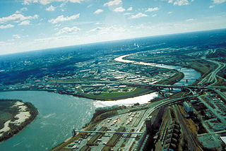
| 解説 | English: Aerial view of Kansas City, Kansas, looking southwest. The Kansas River (right-center) joins the Missouri River (left). A small piece of Kansas City, Missouri is visible on the left of the Missouri River. |
| 場所 | City of Kansas City, State of Kansas, United States of America 39°6′54.64″N 94°36′36.34″W / 39.1151778°N 94.6100944°W |
| 日付 | 撮影日:1999年4月6日 |
| 原典 | U.S. Army Corp of Engineers Digital Visual Library Image page Image description page Digital Visual Library home page |
| 作者 | U.S. Army Corps of Engineers, photographer unknown |
ライセンス
This image or file is a work of a U.S. Army Corps of Engineers soldier or employee, taken or made as part of that person's official duties. As a work of the U.S. federal government, the image is in the public domain.
|
ファイルの履歴
過去の版のファイルを表示するには、その版の日時をクリックしてください。
| 日付と時刻 | サムネイル | 寸法 | 利用者 | コメント | |
|---|---|---|---|---|---|
| 現在の版 | 2007年3月17日 (土) 01:48 | | 1,500 × 1,001 (579キロバイト) | DanMS | {{Information | Description = Aerial view of Kansas City, Kansas, looking southwest. The Kansas River (right-center) joins the Missouri River (left). A small piece of Kansas City, Missouri is visible on the left of the Missouri River. | Source = U.S. |
ファイルの使用状況
以下の 2 ページがこのファイルを使用しています:
グローバルなファイル使用状況
以下に挙げる他のウィキがこの画像を使っています:
- bo.wikipedia.org での使用状況
- br.wikipedia.org での使用状況
- cs.wikipedia.org での使用状況
- da.wikipedia.org での使用状況
- de.wikipedia.org での使用状況
- en.wikipedia.org での使用状況
- eo.wikipedia.org での使用状況
- es.wikipedia.org での使用状況
- fr.wikipedia.org での使用状況
- gd.wikipedia.org での使用状況
- gu.wikipedia.org での使用状況
- gv.wikipedia.org での使用状況
- hsb.wikipedia.org での使用状況
- hu.wikipedia.org での使用状況
- hy.wikipedia.org での使用状況
- id.wikipedia.org での使用状況
- kn.wikipedia.org での使用状況
- ko.wikipedia.org での使用状況
- kw.wikipedia.org での使用状況
- ky.wikipedia.org での使用状況
- la.wikipedia.org での使用状況
- mr.wikipedia.org での使用状況
- mt.wikipedia.org での使用状況
- sc.wikipedia.org での使用状況
- simple.wikipedia.org での使用状況
- sk.wikipedia.org での使用状況
- sv.wikipedia.org での使用状況
- ug.wikipedia.org での使用状況
- uk.wikipedia.org での使用状況
- zh-min-nan.wikipedia.org での使用状況