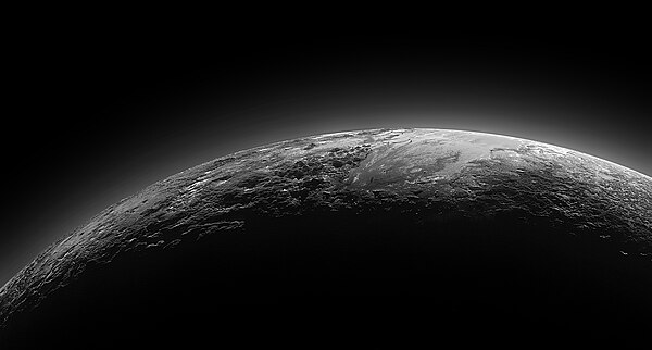
ヒラリー山脈

 ニュー・ホライズンズが2015年7月14日に撮影 | |
| 場所 | トンボー地域(冥王星) |
|---|---|
| 座標 | 北緯5度 東経170度 / 北緯5度 東経170度座標: 北緯5度 東経170度 / 北緯5度 東経170度 |
| 標高 | 3.5±0.4 km (2.2±0.2 mi)[1] |
| 名の由来 | エドモンド・ヒラリー |
ヒラリー山脈(ヒラリーさんみゃく)は冥王星にある山脈で、表面からの高さは3.5 km[1]。 トンボー地域の南、スプートニク平原南西部のテンジング山脈[2] 北西(トンボー地域の南半球部分)にある[3][4]。2015年7月14日に、ニュー・ホライズンズが初めて確認し、NASAが7月24日に発表した[5]。
命名[編集]
この山脈はニュージーランドの登山家で、同行したネパールの登山家テンジン・ノルゲイと共に、1953年5月29日に人類初のエベレスト登頂を行ったエドモンド・ヒラリーにちなみ[6][7][8]、2017年9月7日に「トンボー地域」と他の12の近隣の地形とともに正式に命名された[2]。
ギャラリー[編集]
-
冥王星 – ヒラリー山脈とノルゲイ山脈
(2015年7月14日). -
ヒラリー山脈とノルゲイ山脈
(2015年7月14日). -
ヒラリー山脈とノルゲイ山脈
(2015年7月14日)[3]
動画[編集]
関連項目[編集]
出典[編集]
- ^ a b Schenk, P. M.; Beyer, R. A.; McKinnon, W. B.; Moore, J. M.; Spencer, J. R.; White, O. L.; Singer, K.; Nimmo, F. et al. (2018). “Basins, fractures and volcanoes: Global cartography and topography of Pluto from New Horizons”. Icarus 314: 400–433. Bibcode: 2018Icar..314..400S. doi:10.1016/j.icarus.2018.06.008.
- ^ a b “Pluto Features Given First Official Names”. NASA (2017年9月7日). 2020年1月25日閲覧。
- ^ a b Gipson, Lillian (2015年7月24日). “New Horizons Discovers Flowing Ices on Pluto”. NASA. 2015年7月25日閲覧。
- ^ Messier, Doug (2015年7月24日). “Fly Over Pluto’s Icy Plains & Hillary Mountains”. Parabolicarc.com. 2015年7月24日閲覧。
- ^ Staff (2015年7月17日). “NASA - Video (01:20) - Animated Flyover of Pluto’s Icy Mountain and Plains”. NASA & YouTube. 2015年7月18日閲覧。
- ^ Staff (2015年7月25日). “Pluto mountain range named after Sir Edmund Hillary”. Stuff.co.nz 2015年8月17日閲覧。
- ^ Staff (2015年7月24日). “NASA names Pluto's mountains after Sir Edmund Hillary”. Television New Zealand 2015年8月17日閲覧。
- ^ Pokhrel, Rajan (2015年7月19日). “Nepal’s mountaineering fraternity happy over Pluto mountains named after Tenzing Norgay Sherpa - Nepal's First Landmark In The Solar System”. The Himalayan Times. 2015年7月19日閲覧。


![ヒラリー山脈とノルゲイ山脈 (2015年7月14日)[3]](http://upload.wikimedia.org/wikipedia/commons/thumb/a/ad/NH-Pluto-SputnikPlanum-HillaryMontes-NorgayMontes-20150714.jpg/250px-NH-Pluto-SputnikPlanum-HillaryMontes-NorgayMontes-20150714.jpg)


