File:Greece GHI Solar-resource-map GlobalSolarAtlas World-Bank-Esmap-Solargis.png


File originale (1 842 × 2 063 pixel, dimensione del file: 1,48 MB, tipo MIME: image/png)
| Questo file e la sua pagina di descrizione (discussione · modifica) si trovano su Wikimedia Commons (?) |
Dettagli
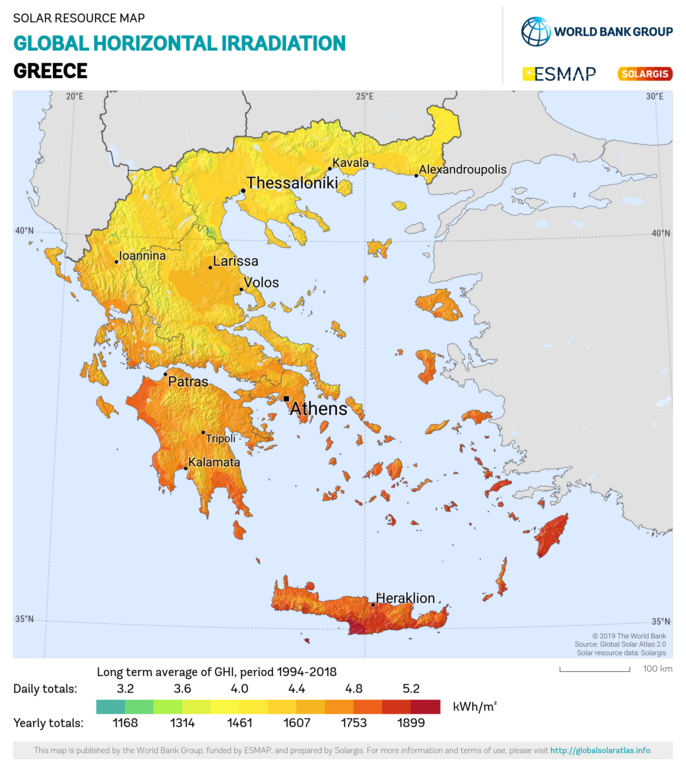
| Descrizione | English: Solar resource: GLOBAL HORIZONTAL IRRADIATION (GHI) - this map provides a summary of the estimated solar energy available for power generation and other energy applications. It represents the long-term average of daily/yearly totals of global horizontal irradiation (GHI). The underlying solar resource database is calculated by the Solargis model from atmospheric and satellite data with 15- or 30-minute time step. The effects of terrain are considered at nominal spatial resolution of 250 m. GHI is the most important parameter for energy yield calculation and performance assessment of flat-plate photovoltaic (PV) technologies. Further details available at: https://globalsolaratlas.info. |
| Data | |
| Fonte | https://globalsolaratlas.info/downloads |
| Autore | Solargis |
| Attribuzione (richiesto dalla licenza) | © The World Bank, Source: Global Solar Atlas 2.0, Solar resource data: Solargis / |
The World Bank Group has published this solar resource map using data from the Global Solar Atlas (GSA), to support the scale-up of solar power in our client countries. This work is funded by the Energy Sector Management Assistance Program (ESMAP), a multi-donor trust fund administered by The World Bank and supported by 18 donor partners. It is part of a global ESMAP initiative on Renewable Energy Resource Mapping that covers biomass, hydropower, solar and wind. This map has been prepared by Solargis, under contract to The World Bank, based on a solar resource database that Solargis owns and maintains. To obtain additional maps and information, please visit: http://globalsolaratlas.info.
Licenza
- Tu sei libero:
- di condividere – di copiare, distribuire e trasmettere quest'opera
- di modificare – di adattare l'opera
- Alle seguenti condizioni:
- attribuzione – Devi fornire i crediti appropriati, un collegamento alla licenza e indicare se sono state apportate modifiche. Puoi farlo in qualsiasi modo ragionevole, ma non in alcun modo che suggerisca che il licenziante approvi te o il tuo uso.
Cronologia del file
Fare clic su un gruppo data/ora per vedere il file come si presentava nel momento indicato.
| Data/Ora | Miniatura | Dimensioni | Utente | Commento | |
|---|---|---|---|---|---|
| attuale | 16:08, 27 gen 2021 | | 1 842 × 2 063 (1,48 MB) | SolarSoft | Updated temporal coverage, recalculated data period. |
| 15:55, 31 mag 2011 |  | 800 × 869 (474 KB) | SolarSoft |
Pagine che usano questo file
La seguente pagina usa questo file:
Utilizzo globale del file
Anche i seguenti wiki usano questo file:
- Usato nelle seguenti pagine di ar.wikipedia.org:
- Usato nelle seguenti pagine di az.wikipedia.org:
- Usato nelle seguenti pagine di el.wikipedia.org:
- Usato nelle seguenti pagine di en.wikipedia.org:
- Usato nelle seguenti pagine di es.wikipedia.org:
- Usato nelle seguenti pagine di fi.wikipedia.org:
- Usato nelle seguenti pagine di fr.wikipedia.org:
- Usato nelle seguenti pagine di ka.wikipedia.org:
- Usato nelle seguenti pagine di ru.wikipedia.org:
- Usato nelle seguenti pagine di sl.wikipedia.org:
- Usato nelle seguenti pagine di sr.wikipedia.org:
- Usato nelle seguenti pagine di test2.wikipedia.org:
- Usato nelle seguenti pagine di te.wikipedia.org: