File:1784 Bocage Map of The Bosphorus and the City of Byzantium - Istanbul - Constantinople - Geographicus - Bosphorus-white-1793.jpg

Dimensioni di questa anteprima: 800 × 544 pixel. Altre risoluzioni: 320 × 218 pixel | 640 × 436 pixel | 1 024 × 697 pixel | 1 280 × 871 pixel | 2 000 × 1 361 pixel.
File originale (2 000 × 1 361 pixel, dimensione del file: 665 KB, tipo MIME: image/jpeg)
| Questo file e la sua pagina di descrizione (discussione · modifica) si trovano su Wikimedia Commons (?) |
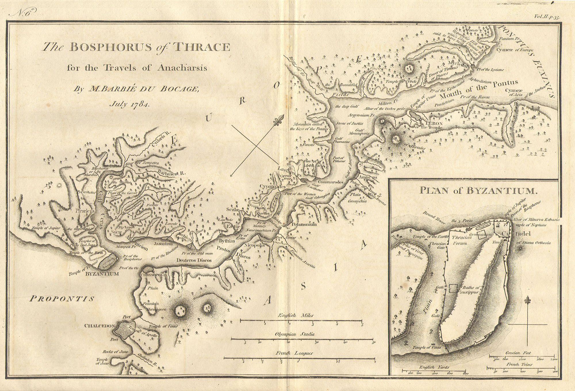
| Bosphorus and the city of Byzantium. | ||||||
|---|---|---|---|---|---|---|
| Artista | ||||||
| Titolo | Bosphorus and the city of Byzantium. | |||||
| Descrizione | English: This lovely map, depicting the Bosphorus and the city of Byzantium, was prepared by Jean-Denis Barbié du Bocage in 1784 for the “Travels of Anarcharsis”. The map shows the narrow naval passage from the Propontis (Sea of Marmara) to the Pontus Euxinus (Black Sea). There is a beautiful inset plan of the Horn of Byzantium. Today Byzantium is Istanbul, but the horn and many of the ancient structures still exists. This map also shows the area in considerable topographical detail. | |||||
| Data | 1784 | |||||
| Dimensioni | altezza: 8,5 pollici (21,5 cm); larghezza: 12 pollici (30,4 cm) | |||||
| Numero d'inventario | Geographicus link: Bosphorus-white-1793 | |||||
| Fonte/Fotografo |
| |||||
| Licenza (Riusare questo file) |
| |||||
| Altre versioni | ||||||

Cronologia del file
Fare clic su un gruppo data/ora per vedere il file come si presentava nel momento indicato.
| Data/Ora | Miniatura | Dimensioni | Utente | Commento | |
|---|---|---|---|---|---|
| attuale | 22:46, 15 mar 2011 | | 2 000 × 1 361 (665 KB) | BotMultichill | {{subst:User:Multichill/Geographicus |link=http://www.geographicus.com/P/AntiqueMap/Bosphorus-white-1793 |product_name=1784 Bocage Map of The Bosphorus and the City of Byzantium / Istanbul / Constantinople |map_title=Bosphorus and the city of Byzantium. | |
Pagine che usano questo file
Le seguenti 3 pagine usano questo file:
Utilizzo globale del file
Anche i seguenti wiki usano questo file:
- Usato nelle seguenti pagine di ar.wikipedia.org:
- Usato nelle seguenti pagine di arz.wikipedia.org:
- Usato nelle seguenti pagine di ast.wikipedia.org:
- Usato nelle seguenti pagine di az.wikipedia.org:
- Usato nelle seguenti pagine di ca.wikipedia.org:
- Usato nelle seguenti pagine di cs.wikipedia.org:
- Usato nelle seguenti pagine di el.wikipedia.org:
- Usato nelle seguenti pagine di en.wikipedia.org:
- Usato nelle seguenti pagine di eo.wikipedia.org:
- Usato nelle seguenti pagine di eu.wikipedia.org:
- Usato nelle seguenti pagine di gl.wikipedia.org:
- Usato nelle seguenti pagine di he.wikivoyage.org:
- Usato nelle seguenti pagine di hu.wikipedia.org:
- Usato nelle seguenti pagine di hy.wikipedia.org:
- Usato nelle seguenti pagine di nap.wikipedia.org:
- Usato nelle seguenti pagine di pt.wikipedia.org:
- Usato nelle seguenti pagine di ro.wikipedia.org:
- Usato nelle seguenti pagine di sk.wikipedia.org:
- Usato nelle seguenti pagine di tr.wikipedia.org:
- Usato nelle seguenti pagine di www.wikidata.org:
- Usato nelle seguenti pagine di zh.wikipedia.org: