קובץ:Autonomous Region Kurdistan-en.png

גודל התצוגה המקדימה הזאת: 581 × 599 פיקסלים. רזולוציות אחרות: 233 × 240 פיקסלים | 465 × 480 פיקסלים | 1,012 × 1,044 פיקסלים.
לקובץ המקורי (1,012 × 1,044 פיקסלים, גודל הקובץ: 514 ק"ב, סוג MIME: image/png)
| זהו קובץ שמקורו במיזם ויקישיתוף. תיאורו בדף תיאור הקובץ המקורי (בעברית) מוצג למטה. |
תקציר
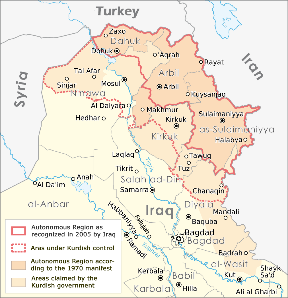
| תיאור | English: Map of the Autonomous Region Kurdistan, created by Maximilian Dörrbecker, translated into English by ilyacadiz |
| תאריך יצירה | |
| מקור | Autonome Region Kurdistan (Karte).png |
| יוצר | Maximilian Dörrbecker (Chumwa), derviative work by ilyacadiz |
| גרסאות אחרות |
|
.png)
רישיון
הקובץ הזה מתפרסם לפי תנאי רישיון קריאייטיב קומונז ייחוס-שיתוף זהה 3.0 לא מותאם.
- הנכם רשאים:
- לשתף – להעתיק, להפיץ ולהעביר את העבודה
- לערבב בין עבודות – להתאים את העבודה
- תחת התנאים הבאים:
- ייחוס – יש לתת ייחוס הולם, לתת קישור לרישיון, ולציין אם נעשו שינויים. אפשר לעשות את זה בכל צורה סבירה, אבל לא בשום צורה שמשתמע ממנה שמעניק הרישיון תומך בך או בשימוש שלך.
- שיתוף זהה – אם תיצרו רמיקס, תשנו, או תבנו על החומר, חובה עליכם להפיץ את התרומות שלך לפי תנאי רישיון זהה או תואם למקור.
היסטוריית הקובץ
ניתן ללחוץ על תאריך/שעה כדי לראות את הקובץ כפי שנראה באותו זמן.
| תאריך/שעה | תמונה ממוזערת | ממדים | משתמש | הערה | |
|---|---|---|---|---|---|
| נוכחית | 14:02, 20 באוקטובר 2017 | | 1,044 × 1,012 (514 ק"ב) | Rob984 | The southern part of the Kifri district was not incorporated. The northern part in the Sulaymaniyah Governorate was, which may be the reason for the confusions (there is effectively two "Kifri districts") |
| 20:37, 14 באוקטובר 2008 |  | 1,044 × 1,012 (535 ק"ב) | Ilyacadiz | {{Information |Description={{en|1=Map of the Autonomous Region Kurdistan, created by Maximilian Dörrbecker, translated into English by ilyacadiz }} |Source=Image:Autonome Region Kurdistan (Karte).png |Author=Maximilian Dörrbecker (Chumwa) |Date=October |
שימוש בקובץ
הדף הבא משתמש בקובץ הזה:
שימוש גלובלי בקובץ
אתרי הוויקי השונים הבאים משתמשים בקובץ זה:
- שימוש באתר af.wikipedia.org
- שימוש באתר ca.wikipedia.org
- שימוש באתר ckb.wikipedia.org
- שימוש באתר en.wikipedia.org
- שימוש באתר fa.wikipedia.org
- שימוש באתר fr.wikipedia.org
- שימוש באתר hr.wikipedia.org
- שימוש באתר it.wikipedia.org
- שימוש באתר ku.wikipedia.org
- שימוש באתר nl.wikipedia.org
- שימוש באתר no.wikipedia.org
- שימוש באתר sh.wikipedia.org
- שימוש באתר sr.wikipedia.org