Fichier:PIA02820.jpg


Taille de cet aperçu : 800 × 554 pixels. Autres résolutions : 320 × 222 pixels | 640 × 443 pixels | 1 024 × 709 pixels | 1 280 × 886 pixels | 2 560 × 1 772 pixels | 4 000 × 2 769 pixels.
Fichier d’origine (4 000 × 2 769 pixels, taille du fichier : 1,06 Mio, type MIME : image/jpeg)
Ce fichier et sa description proviennent de Wikimedia Commons.
Description
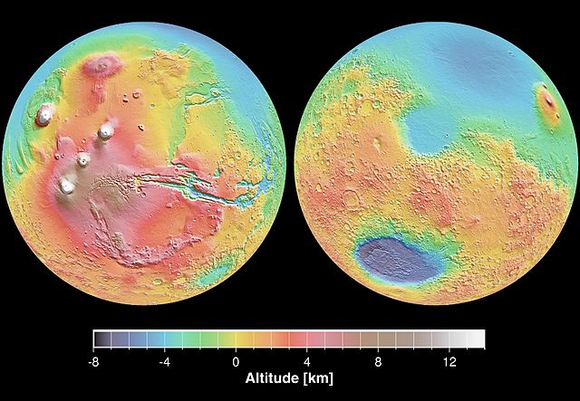
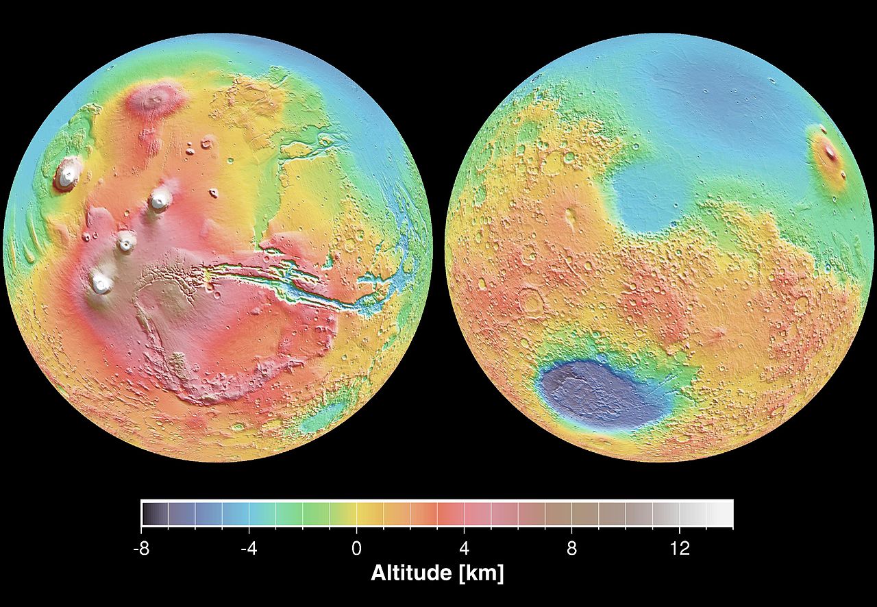
| Description | English: These maps are global false-color topographic views of Mars at different orientations from the Mars Orbiter Laser Altimeter (MOLA). The maps are orthographic projections that contain over 200,000,000 points and about 5,000,000 altimetric crossovers. The spatial resolution is about 15 kilometers at the equator and less at higher latitudes. The vertical accuracy is less than 5 meters. The right hand image view features the Hellas impact basin (in purple, with red annulus of high standing material). The left hand features the Tharsis topographic rise (in red and white). Note also the subtle textures associated with resurfacing of the northern hemisphere lowlands in the vicinity of the Utopia impact basin. This data was compiled by the Mars Orbiter Laser Altimeter (MOLA) Team, led by David Smith at the Goddard Space Flight Center in Greenbelt, MD. Español: Levantamento topográfico realizado pela sonda norte-americana Mars Global Surveyor |
| Date | |
| Source | http://photojournal.jpl.nasa.gov/catalog/PIA02820 |
| Auteur | NASA/JPL |
Cette image ou vidéo a été cataloguée par le Jet Propulsion Lab de la National Aeronautics and Space Administration (NASA) des États-Unis sous Photo ID : PIA02820.Ce bandeau n’indique rien sur le statut de l’œuvre au regard du droit d'auteur. Un bandeau de droit d’auteur est requis. Voir Commons:À propos des licences pour plus d’informations. Autres langues :
|
Conditions d’utilisation
| Ce fichier provient de la NASA. Sauf exception, les documents créés par la NASA ne sont pas soumis à copyright. Pour plus d'informations, voir la politique de copyright de la NASA. | ||
 | Attention :
|
Historique du fichier
Cliquer sur une date et heure pour voir le fichier tel qu'il était à ce moment-là.
| Date et heure | Vignette | Dimensions | Utilisateur | Commentaire | |
|---|---|---|---|---|---|
| actuel | 29 décembre 2005 à 21:23 | | 4 000 × 2 769 (1,06 Mio) | Severino666~commonswiki | Levantamento topográfico realizado pela sonda norte-americana Mars Global Surveyor Category:Mars |
Utilisation du fichier
Les 2 pages suivantes utilisent ce fichier :
Usage global du fichier
Les autres wikis suivants utilisent ce fichier :
- Utilisation sur ca.wikipedia.org
- Utilisation sur cs.wikipedia.org
- Utilisation sur en.wikipedia.org
- Utilisation sur en.wikibooks.org
- Utilisation sur en.wikiversity.org
- Utilisation sur es.wikipedia.org
- Utilisation sur fi.wikipedia.org
- Utilisation sur it.wikipedia.org
- Utilisation sur ja.wikipedia.org
- Utilisation sur mk.wikipedia.org
- Utilisation sur ml.wikipedia.org
- Utilisation sur nap.wikipedia.org
- Utilisation sur no.wikipedia.org
- Utilisation sur olo.wikipedia.org
- Utilisation sur pt.wikipedia.org
- Utilisation sur pt.wikibooks.org
- Utilisation sur ro.wikipedia.org
- Utilisation sur ru.wikipedia.org
- Utilisation sur sk.wikipedia.org
- Utilisation sur sv.wikipedia.org
- Utilisation sur zh.wikipedia.org