Fichier:Moon landing map surveyor.svg


Taille de cet aperçu PNG pour ce fichier SVG : 616 × 599 pixels. Autres résolutions : 247 × 240 pixels | 493 × 480 pixels | 790 × 768 pixels | 1 053 × 1 024 pixels | 2 105 × 2 048 pixels | 1 100 × 1 070 pixels.
Fichier d’origine (Fichier SVG, nominalement de 1 100 × 1 070 pixels, taille : 382 kio)
Ce fichier et sa description proviennent de Wikimedia Commons.
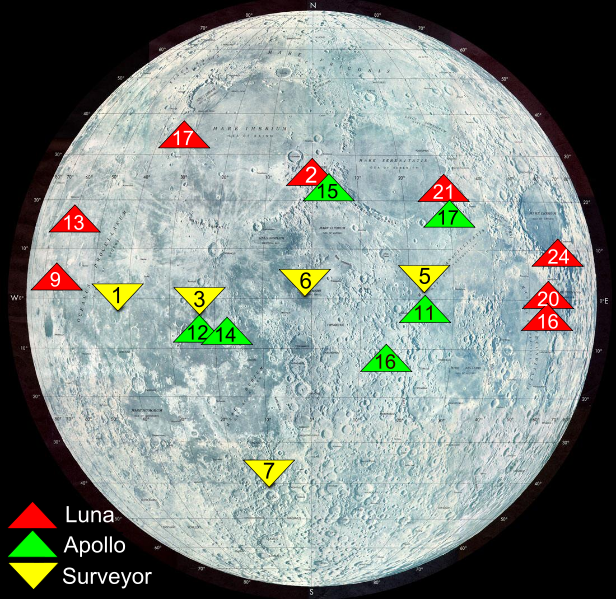
| Description | Map shows landing sites of Surveyor, Apollo and Luna missions source: http://nssdc.gsfc.nasa.gov/planetary/lunar/moon_landing_map.jpg |
| Date | (UTC) |
| Source | |
| Auteur |
|
| Autres versions | []
|


| Cette image a été retouchée, ce qui signifie qu'elle a été modifiée par ordinateur et est différente de l'image d'origine. Liste des modifications : Big labels for surveyor. L'image d'origine se trouve ici : Moon landing map.jpg:
|
| Ce fichier provient de la NASA. Sauf exception, les documents créés par la NASA ne sont pas soumis à copyright. Pour plus d'informations, voir la politique de copyright de la NASA. | ||
 | Attention :
|
Journal des téléversements d’origine
This image is a derivative work of the following images:
- File:Moon_landing_map.jpg licensed with PD-USGov-NASA
- 2004-12-10T13:17:44Z Srbauer 1100x1070 (294476 Bytes) Map shows landing sites of Surveyor, Apollo and Luna missions
Téléversé avec derivativeFX
Historique du fichier
Cliquer sur une date et heure pour voir le fichier tel qu'il était à ce moment-là.
| Date et heure | Vignette | Dimensions | Utilisateur | Commentaire | |
|---|---|---|---|---|---|
| actuel | 31 janvier 2011 à 22:07 | | 1 100 × 1 070 (382 kio) | X-romix | All labels |
| 30 janvier 2011 à 01:12 |  | 1 100 × 1 070 (335 kio) | X-romix | correct SVG | |
| 30 janvier 2011 à 01:09 |  | 744 × 1 052 (334 kio) | X-romix | {{Information |Description=Map shows landing sites of Surveyor, Apollo and Luna missions source: http://nssdc.gsfc.nasa.gov/planetary/lunar/moon_landing_map.jpg |Source=*File:Moon_landing_map.jpg |Date=2011-01-29 23:08 (UTC) |Author=*[[:File:Moon_l |
Utilisation du fichier
Les 2 pages suivantes utilisent ce fichier :
Usage global du fichier
Les autres wikis suivants utilisent ce fichier :
- Utilisation sur ca.wikipedia.org
- Utilisation sur cs.wikipedia.org
- Utilisation sur en.wikipedia.org
- Utilisation sur et.wikipedia.org
- Utilisation sur he.wikipedia.org
- Utilisation sur id.wikipedia.org
- Utilisation sur it.wikipedia.org
- Utilisation sur lv.wikipedia.org
- Utilisation sur pt.wikipedia.org
- Utilisation sur ro.wikipedia.org
- Utilisation sur tr.wikipedia.org