Fichier:Map of Peterloo Massacre.png

Taille de cet aperçu : 800 × 534 pixels. Autres résolutions : 320 × 214 pixels | 640 × 427 pixels | 1 024 × 684 pixels | 1 280 × 855 pixels | 2 403 × 1 605 pixels.
Fichier d’origine (2 403 × 1 605 pixels, taille du fichier : 679 kio, type MIME : image/png)
Ce fichier et sa description proviennent de Wikimedia Commons.
 | Cette image (de type carte) devrait être recréée dans un format vectoriel, en tant que fichier SVG. Cela offrirait plusieurs avantages : voir Commons:Media for cleanup pour plus d'informations. Si une version SVG de cette image est déjà disponible, merci de bien vouloir l'envoyer. Après cela, remplacez ce modèle par {{vector version available|nouveau nom d'image.svg}}. |
Description
| Titre | ||||||||||
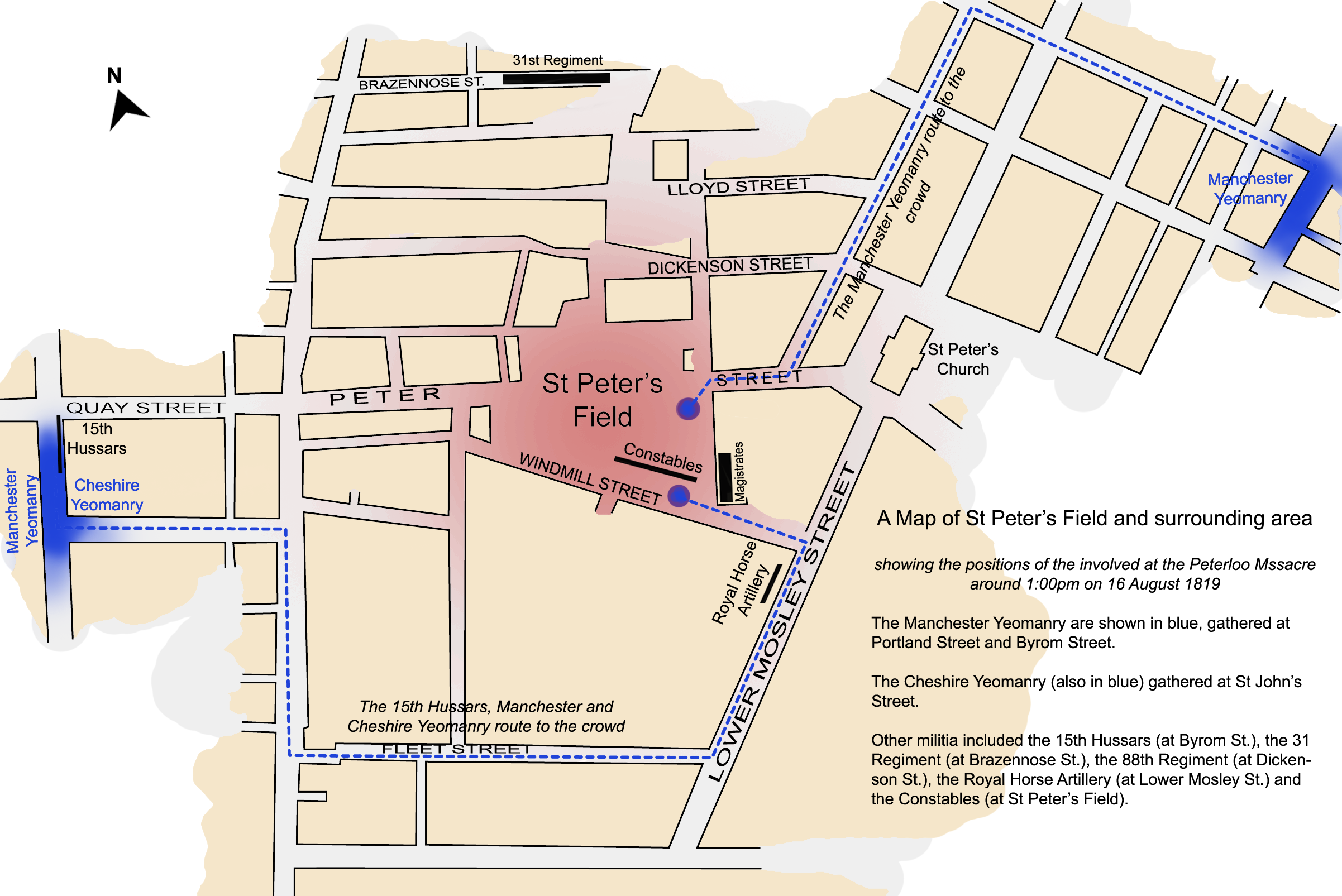
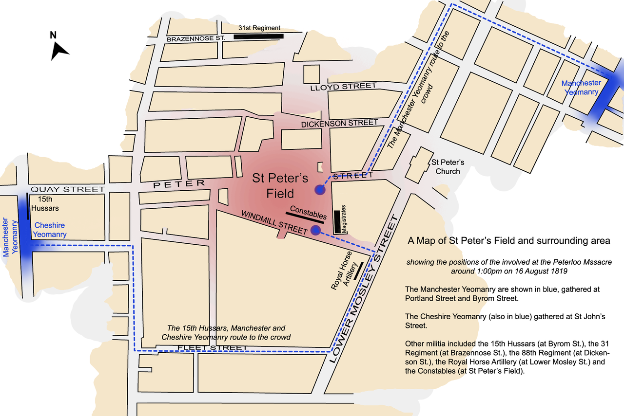
| Légende de la carte | Protesters Manchester & Cheshire Yeomanry | |||||||||
| Date | ||||||||||
| Source | Travail personnel par Jhamez84 | |||||||||
| Créé par | ||||||||||
| Données géotemporelles | ||||||||||
| Date représentée | 16 août 1819, 13:00 | |||||||||
| Lieu | St Peter's Square | |||||||||
| Orientation |  | |||||||||
| Rectangle englobant |
| |||||||||
| Géoréférencement | ||||||||||
| Données d'archives | ||||||||||
| artwork-references | based on Reid, Robert (1989) The Peterloo Massacre, William Heinemann Ltd ISBN : 0434629014. | |||||||||
Conditions d’utilisation
Moi, en tant que détenteur des droits d’auteur sur cette œuvre, je la publie sous les licences suivantes :
 | Vous avez la permission de copier, distribuer et modifier ce document selon les termes de la GNU Free Documentation License version 1.2 ou toute version ultérieure publiée par la Free Software Foundation, sans sections inaltérables, sans texte de première page de couverture et sans texte de dernière page de couverture. Un exemplaire de la licence est inclus dans la section intitulée GNU Free Documentation License. |
Ce fichier est disponible selon les termes de la licence Creative Commons Attribution 3.0 Non transposée.
- Vous êtes libre :
- de partager – de copier, distribuer et transmettre cette œuvre
- d’adapter – de modifier cette œuvre
- Sous les conditions suivantes :
- paternité – Vous devez donner les informations appropriées concernant l'auteur, fournir un lien vers la licence et indiquer si des modifications ont été faites. Vous pouvez faire cela par tout moyen raisonnable, mais en aucune façon suggérant que l’auteur vous soutient ou approuve l’utilisation que vous en faites.
Vous pouvez choisir l’une de ces licences.
Historique du fichier
Cliquer sur une date et heure pour voir le fichier tel qu'il était à ce moment-là.
| Date et heure | Vignette | Dimensions | Utilisateur | Commentaire | |
|---|---|---|---|---|---|
| actuel | 4 avril 2008 à 03:45 | | 2 403 × 1 605 (679 kio) | Jza84 | {{Information |Description=A map of St Peter's Field, Manchester, England at the time of the Peterloo Massacre of 1819. This map, highlights the positions of those parties involved in the massacre as they were documented to have been at 1.00pm. |Source |
Utilisation du fichier
Les 2 pages suivantes utilisent ce fichier :
Usage global du fichier
Les autres wikis suivants utilisent ce fichier :
- Utilisation sur az.wikipedia.org
- Utilisation sur en.wikipedia.org
- Utilisation sur fi.wikipedia.org
- Utilisation sur it.wikipedia.org
- Utilisation sur ja.wikipedia.org
- Utilisation sur tr.wikipedia.org
- Utilisation sur www.wikidata.org
- Utilisation sur zh.wikipedia.org