Fichier:Japanese Occupation - Map.jpg

Fichier d’origine (1 119 × 857 pixels, taille du fichier : 482 kio, type MIME : image/jpeg)
Ce fichier et sa description proviennent de Wikimedia Commons.
 | Une version vectorielle de cette image existe, dans le format « SVG ». Si elle n’est pas inférieure, elle devrait être utilisée à la place de la présente version pour des affichages en plus grandes dimensions ou nécessitant une meilleure résolution. File:Japanese Occupation - Map.jpg → File:Japanese Occupation of China 1940.svg Pour plus d’informations sur les images vectorielles, consultez la page de transition de Commons vers le format SVG. Voir aussi les informations à propos de la manière dont le logiciel MediaWiki gère les images au format SVG. |  |
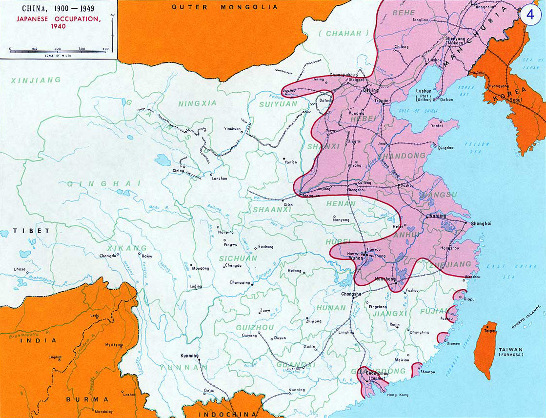
- Description: English: Japanese Occupation - 1940Bân-lâm-gú:Ji̍t-pún 1940-nî tī Tiong-kok tsiàm ê sóo-tsāi(hún-âng-sik).中文:中国抗日战争中,1940年日军占领区(粉紅色)。
- Source: www.dean.usma.edu - The photo source linked here only has the photo in this low-resolution JPG format.
- Other versions: File:Second Sino-Japanese War WW2.png
- Background information:
In 1938 the predecessors of what is today The Department of History at the United States Military Academy began developing a series of campaign atlases to aid in teaching cadets a course entitled, "History of the Military Art." Since then, the Department has produced over six atlases and more than one thousand maps, encompassing not only America’s wars but global conflicts as well.
In keeping abreast with today's technology, the Department of History is providing these maps on the internet as part of the department's outreach program. The maps were created by the United States Military Academy’s Department of History and are the digital versions from the atlases printed by the United States Defense Printing Agency. We gratefully acknowledge the accomplishments of the department's former cartographer, Mr. Edward J. Krasnoborski, along with the works of our present cartographer, Mr. Frank Martini.
Please be aware that these maps are large in file size and may require substantial download times.
Cette image est une œuvre d'un soldat ou d'un employé de l'U.S. Army, réalisée dans le cadre de ses activités professionnelles. En tant qu'œuvre du gouvernement fédéral des États-Unis d'Amérique, cette image fait partie du domaine public.
|  |
derivative works
Œuvres dérivées de ce fichier : OcupaciónJaponesaDeChina1940.svg
Historique du fichier
Cliquer sur une date et heure pour voir le fichier tel qu'il était à ce moment-là.
| Date et heure | Vignette | Dimensions | Utilisateur | Commentaire | |
|---|---|---|---|---|---|
| actuel | 14 novembre 2012 à 21:17 | | 1 119 × 857 (482 kio) | Mys 721tx | Reverted to version as of 22:05, 9 March 2010 Revert to larger picture. |
| 14 novembre 2012 à 05:58 |  | 699 × 600 (111 kio) | Amysze123 | ||
| 10 mars 2010 à 00:05 |  | 1 119 × 857 (482 kio) | Ras67 | rotated and cropped | |
| 17 juin 2005 à 10:32 |  | 1 141 × 870 (172 kio) | W.wolny |
Utilisation du fichier
Les 4 pages suivantes utilisent ce fichier :
Usage global du fichier
Les autres wikis suivants utilisent ce fichier :
- Utilisation sur ar.wikipedia.org
- Utilisation sur be.wikipedia.org
- Utilisation sur bs.wikipedia.org
- Utilisation sur ca.wikipedia.org
- Utilisation sur cs.wikipedia.org
- Utilisation sur da.wikipedia.org
- Utilisation sur el.wikipedia.org
- Utilisation sur en.wikipedia.org
- Utilisation sur en.wikibooks.org
- Utilisation sur es.wikipedia.org
- Utilisation sur et.wikipedia.org
- Utilisation sur fi.wikipedia.org
- Utilisation sur he.wikipedia.org
- Utilisation sur hr.wikipedia.org
- Utilisation sur hu.wikipedia.org
- Utilisation sur hy.wikipedia.org
- Utilisation sur id.wikipedia.org
- Utilisation sur ja.wikipedia.org
- Utilisation sur jv.wikipedia.org
- Utilisation sur kk.wikipedia.org
- Utilisation sur ko.wikipedia.org
- Utilisation sur la.wikipedia.org
- Utilisation sur lv.wikipedia.org
- Utilisation sur ms.wikipedia.org
- Utilisation sur my.wikipedia.org
- Utilisation sur nl.wikipedia.org
- Utilisation sur no.wikipedia.org
- Utilisation sur pt.wikipedia.org
- Utilisation sur ro.wikipedia.org
Voir davantage sur l’utilisation globale de ce fichier.