پرونده:John Pinkerton. Map of Persia. 1818.H. Ghilan.jpg

پروندهٔ اصلی (۶۲۷ × ۶۰۵ پیکسل، اندازهٔ پرونده: ۱۲۷ کیلوبایت، نوع MIME پرونده: image/jpeg)
این پرونده در ویکیانبار موجود است. محتویات صفحهٔ توصیف آن در زیر نمایش داده میشود. |
خلاصه
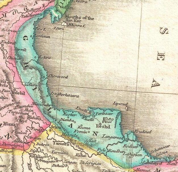
| توضیح | English: A rare and important 1818 map of Persia by John Pinkerton. Depicts from the Black Sea eastward as far as the Indus Valley, extends north to the Aral Sea and South to the Persian Gulf and the Arabian Sea. Includes the modern day countries of Iran and Afghanistan, as well as parts of adjacent Pakistan, Kuwait, Iraq, Turkey and Arabia. Notes both political and physical geographic elements, including rivers, mountains, under sea dangers, various tribal regions, cities, ruins, and canals. In particular, notes the ruins of both Babylon and Persepolis. Drawn by L. Herbert and engraved by Samuel Neele under the direction of John Pinkerton. The map comes from the scarce American edition of Pinkerton’s Modern Atlas, published by Thomas Dobson & Co. of Philadelphia in 1818. | ||||||||||||||||||||
| تاریخ | (undated) | ||||||||||||||||||||
| منبع |
Pinkerton, J., A Modern Atlas, from the Lates and Best Authorities, Exhibiting the Various Divisions of the World with its chief Empires, Kingdoms, and States; in Sixty Maps, carefully reduced from the Larges and Most Authentic Sources. 1818, Philadelphia, Thomas Dobson Edition.
| ||||||||||||||||||||
| پدیدآور |
| ||||||||||||||||||||
_-_Geographicus_-_Persia2-pinkerton-1818.jpg)

اجازهنامه
| این اثر هنری دوبعدی که در این نگاره دیده میشود بخاطر تاریخ درگذشت پدیدآورنده آن یا تاریخ انتشارش هماکنون در سراسر جهان در مالکیت عمومی قرار دارد و استفاده از آن آزاد است.
بنابراین تکثیر آن در ایالات متحده آمریکا، آلمان و بسیاری کشورهای دیگر آزاد است. | ||||
تاریخچهٔ پرونده
روی تاریخ/زمانها کلیک کنید تا نسخهٔ مربوط به آن هنگام را ببینید.
| تاریخ/زمان | بندانگشتی | ابعاد | کاربر | توضیح | |
|---|---|---|---|---|---|
| کنونی | ۴ مهٔ ۲۰۱۱، ساعت ۲۳:۱۶ | | ۶۲۷ در ۶۰۵ (۱۲۷ کیلوبایت) | Geagea | == {{int:filedesc}} == {{Information |Description={{en|1=A rare and important 1818 map of Persia by John Pinkerton. Depicts from the Black Sea eastward as far as the Indus Valley, extends north to the Aral Sea and South to the Persian Gulf and the Arab |
کاربرد پرونده
صفحههای زیر از این تصویر استفاده میکنند:
کاربرد سراسری پرونده
ویکیهای دیگر زیر از این پرونده استفاده میکنند:
- کاربرد در de.wikivoyage.org
- کاربرد در glk.wikipedia.org