پرونده:East-Hem 700ad.jpg

پروندهٔ اصلی (۳٬۲۴۰ × ۱٬۹۰۳ پیکسل، اندازهٔ پرونده: ۹۲۴ کیلوبایت، نوع MIME پرونده: image/jpeg)
این پرونده در ویکیانبار موجود است. محتویات صفحهٔ توصیف آن در زیر نمایش داده میشود. |
 | این historical map نگاره میبایست با استفاده از گرافیک برداری اسویجی فایل بازسازی شوند. این چند مزیت دارد؛ Commons:Media for cleanup را برای اطلاعات بیشتر ببینید. اگر حالت برداری آن در حال حاضر موجود است، لطفاً آن را بار کنید. پس از بارکردن یک اسویجی، این الگو را با {{vector version available|new image name.svg}} جایگزین کنید. |


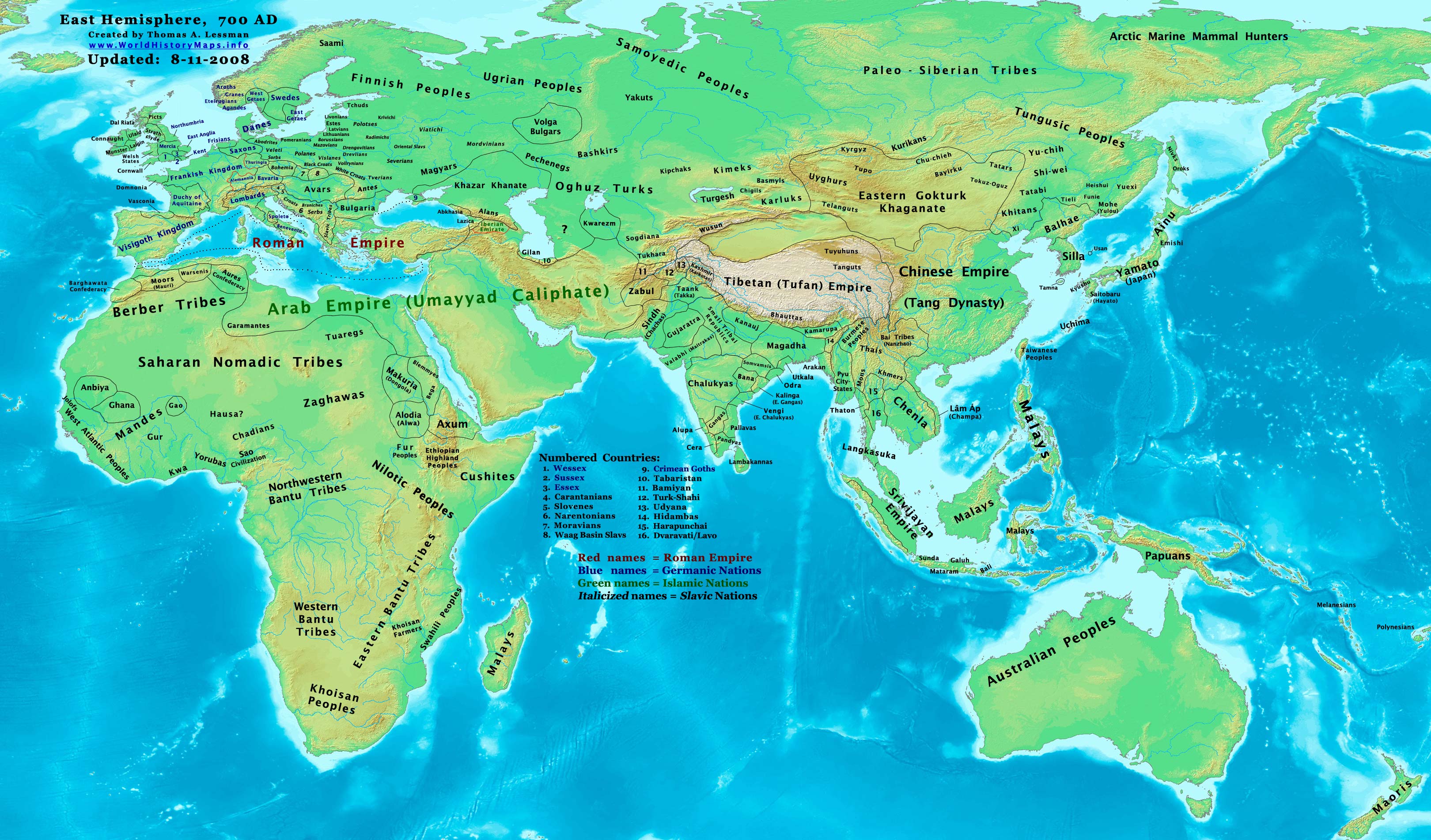
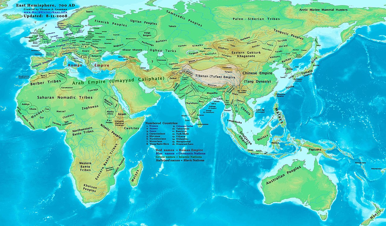
| توضیح | Eastern Hemisphere in 700 AD. |
| منبع | self-made (For reference information, see the Map Source References section below.) |
| پدیدآور | Thomas Lessman (Contact!) |
| اجازهنامه (استفادهٔ مجدد از این پرونده) | من، صاحب حقوق قانونی این اثر، به این وسیله این اثر را تحث اجازهنامهٔ ذیل منتشر میکنم: این پرونده با اجازهنامهٔ کریتیو کامانز Attribution-Share Alike 3.0 سازگار نشده منتشر شدهاست.
|
| دیگر نسخهها | آثار انشقاقی از این پرونده: Part of East-Hem 700ad.jpg see East-Hem_700ad.jpg file history on Wikipedia. |
Map Summary
Original Source URL: http://www.thomaslessman.com/History/images/East-Hem_700ad.jpg.
This map of the Eastern Hemisphere in 700 AD was created by Thomas Lessman, based on information from the sources listed below. This map is free for educational use (see Permission info above). When using this map, please mention that it is available for free at www.WorldHistoryMaps.info.
Map Source References
- Remember, sources often conflict with each other. This map is only as accurate as the information that is available to me. To report any errors or to help further this work, please click here, or email Thomas Lessman at talessman@yis.us
References for information contained in this map:
1. Borders of Europe are mostly derived from the www.Euratlas.com map of Europe in 700 AD archive copy at the Wayback Machine.
- (Please note: User:Bogomolov.PL has done a great job of showing me possible discrepancies in my north European borders compared to this source, due to the differences in the geographical layout of the maps.)
2. Asian information is mostly derived from the following sources:
- 2a. Wikimedia's World Map 700 CE, created by User:Javierfv1212.
- 2b. Map of Asia in 750 AD, from Huhai.net.
- Please note: borders between Tibet and India are in question due to conflicts between source information:
- 2c. My depiction of Tibet's borders with India are based on these sources:
- 1: DK Atlas of World History (2000 edition, pg. 262), showing Tibet's borders in 800 AD, with northern India (the entire length of the Ganges, almost to the Indus river) under Tibet's control.
- 2: Huhai.net's map of Asia in 750 AD, which shows Tibetan control over Kamarupa, Bengal, and Pala.
- 3: "Himalayan Region, 500–1000 A.D." in Timeline of Art History. New York: The Metropolitan Museum of Art, (October 2001)
- 4: Google Book's "History of Tibet" (Page 54), makes several notes of Nepal's Licchavi dynasty as vassals of Tibet, and also says that India's Pala Empire under King Dharmapala accepted Tibetan overlordship.
- 5: Google Book's "Ancient India", (Page 632), describes Tibetan activities during the reigns of Songtsan Gampo and King Harsha of Kannauj. Also describes the Tibetan subjucation of Kamarupa and Kannauj after the death of King Harsha.
- 6: Wikipedia's article about Tibetan King Songtsän Gampo states that Tibet and Nepal invaded India in 648 AD and defeated Harsha's successor, after the Indian King had attacked a Chinese envoy named Wang Xuanze. (That statement referenced with Stein, R. A. Tibetan Civilization 1962. Revised English edition, 1972, Faber & Faber, London. Reprint, 1972. Stanford University Press, p. 62. ISBN 0-8047-0806-1 cloth; ISBN 0-8047-0901-7 pbk., pp. 58-59)
- Possible alternative borders for Indias Kamarupa, Gauda, Tripura, and Manipur can be seen on User:Porikolpok_Oxom map of Kamarupa 7th-8th Century AD.
3. Fringe areas like Africa, Australia, Siberia, etc. derive from Wikimedia's map of the World Map 700 CE, created by User:Javierfv1212.
4. Much of the information in this map was cross-checked with Bruce Gordon's Regnal Chronologies.
Other Maps by Thomas Lessman
| Maps of the eastern hemisphere showing history Bold dates are available on Wikimedia or Wikipedia. | ||
| Primeval | ||
| Ancient
| ·| 600 BC | 550 BC | 527 BC | 500 BC | 400 BC | ·| 1 AD | 50 AD | 100 AD | 200 AD | 300 AD | | |
| Medieval | ·| 500 AD | 565 AD | 600 AD | 700 AD | | |
| Modern | ·| 1500 AD | · * For historical maps of the whole world, | |
تاریخچهٔ پرونده
روی تاریخ/زمانها کلیک کنید تا نسخهٔ مربوط به آن هنگام را ببینید.
| تاریخ/زمان | بندانگشتی | ابعاد | کاربر | توضیح | |
|---|---|---|---|---|---|
| کنونی | ۱۳ اکتبر ۲۰۲۲، ساعت ۱۷:۴۲ | | ۳٬۲۴۰ در ۱٬۹۰۳ (۹۲۴ کیلوبایت) | Gyalu22 | Reverted to version as of 20:11, 11 August 2008 (UTC) This is not an ethnic map. |
| ۶ مهٔ ۲۰۱۶، ساعت ۱۳:۳۷ |  | ۳٬۲۴۰ در ۱٬۹۰۳ (۲٫۳۳ مگابایت) | Julieta39 | Cosmetic changes according with « Putzger historischer Weltatlas Cornelsen » 1990 - ISBN 3-464-00176-8 ; « Atlas historique Georges Duby » Larousse 1987 - ISBN 2-03-503009-9 ; André & Jean Sellier's « Atlas des Peuples » La Découverte : issues... | |
| ۱۱ اوت ۲۰۰۸، ساعت ۲۰:۱۱ |  | ۳٬۲۴۰ در ۱٬۹۰۳ (۹۲۴ کیلوبایت) | Talessman | {{Information |Description= |Source= |Date= |Author= |Permission= |other_versions= }} | |
| ۹ مهٔ ۲۰۰۸، ساعت ۱۸:۳۷ |  | ۳٬۲۴۰ در ۱٬۹۰۳ (۷۳۷ کیلوبایت) | Talessman | {{Information |Description=Eastern Hemisphere in 700 AD. |Source=self-made |Author=Thomas Lessman |Permission={{self|cc-by-sa-3.0}} }} |
کاربرد پرونده
صفحههای زیر از این تصویر استفاده میکنند:
کاربرد سراسری پرونده
ویکیهای دیگر زیر از این پرونده استفاده میکنند:
- کاربرد در ar.wikipedia.org
- کاربرد در arz.wikipedia.org
- کاربرد در azb.wikipedia.org
- کاربرد در be.wikipedia.org
- کاربرد در bs.wikipedia.org
- کاربرد در ca.wikipedia.org
- کاربرد در cs.wikipedia.org
- کاربرد در da.wikipedia.org
- کاربرد در de.wikipedia.org
- کاربرد در en.wikipedia.org
- 7th century
- 8th century
- 745
- 700
- History of the Khitans
- User:Tompw/sandbox10
- File:Tibet 700ad.jpg
- User:Talessman/Maps
- User talk:Talessman/Maps
- Tibetan Empire
- History of the Great Wall of China
- User:Benjamin Trovato/sandbox
- List of states during the Middle Ages
- List of political entities in the 7th century
- User:Navops47/sandbox10
- Wikipedia:Graphics Lab/Map workshop/Archive/Feb 2018
- User:Falcaorib
- کاربرد در es.wikipedia.org
- کاربرد در et.wikipedia.org
- کاربرد در frr.wikipedia.org
- کاربرد در fr.wikipedia.org
- کاربرد در gl.wikipedia.org
- کاربرد در hi.wikipedia.org
- کاربرد در hu.wikipedia.org
- کاربرد در hy.wikipedia.org
- کاربرد در id.wikipedia.org
- کاربرد در it.wikipedia.org
- کاربرد در ja.wikipedia.org
نمایش استفادههای سراسری از این پرونده.