پرونده:1794 Anville Map of the Ancient World - Geographicus - AncientWorld-anville-1794.jpg


اندازهٔ این پیشنمایش: ۸۰۰ × ۵۷۹ پیکسل. کیفیتهای دیگر: ۳۲۰ × ۲۳۲ پیکسل | ۶۴۰ × ۴۶۳ پیکسل | ۱٬۰۲۴ × ۷۴۱ پیکسل | ۱٬۲۸۰ × ۹۲۶ پیکسل | ۲٬۵۶۰ × ۱٬۸۵۲ پیکسل | ۵٬۰۰۰ × ۳٬۶۱۸ پیکسل.
پروندهٔ اصلی (۵٬۰۰۰ × ۳٬۶۱۸ پیکسل، اندازهٔ پرونده: ۴٫۶۹ مگابایت، نوع MIME پرونده: image/jpeg)
این پرونده در ویکیانبار موجود است. محتویات صفحهٔ توصیف آن در زیر نمایش داده میشود. |
| Jean Baptiste Bourguignon d'Anville: Orbis Veteribus Notus. ( | |||||||||||||||||||||
|---|---|---|---|---|---|---|---|---|---|---|---|---|---|---|---|---|---|---|---|---|---|
| هنرمند |
| ||||||||||||||||||||
| عنوان | Orbis Veteribus Notus. | ||||||||||||||||||||
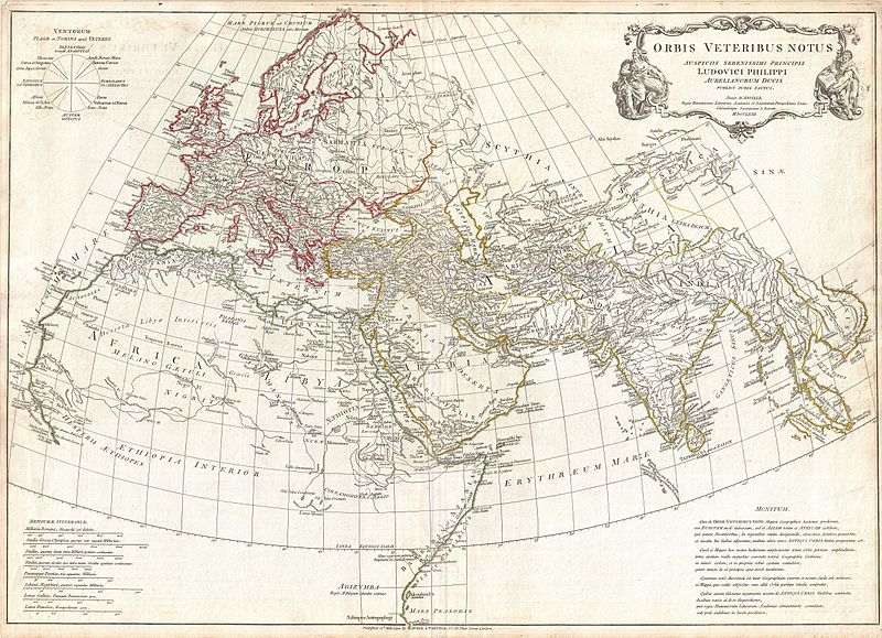
| توضیح | English: A large and dramatic composite 1794 map of the world as it was known to the ancients, by J. B. B. D'Anville. Covers all of Europe, Asia Minor, Arabia and India, much of Northern Africa, and parts of Southeast Asia. D'Anville compiled this map from various sources including Ptolemy, Herodotus, Thucydides, and others. In Africa, the author notes various cities from Ptolemy's Geographica , including Rapta, Axum, Garama, and others. Includes the Mountains of the Moon, Lakes of the Nile, and other conjectural destinations. Far in the south a note reads, Aethiopes Anthropophagi, which essentially translates to African Cannibals. In the Far East a number of classical locals are noted, including the island of Taprobana (Celon) and the empires of Southeast Asia. Details mountains, rivers, cities, roadways, and lakes with political divisions highlighted in outline color. Title cartouche appears in a baroque frame in the upper left quadrant. Cartouche is flanked on either side by malignant appearing figure with a telescope and a studious scholar reading a book. Includes eight distance scales, bottom left, referencing various measurement systems common in antiquity. Text in Latin and English. Drawn by J. B. B. D'Anville in 1762 and published in 1794 by Laurie and Whittle, London. | ||||||||||||||||||||
| تاریخ | dated 1763, published 1794 | ||||||||||||||||||||
| ابعاد | بلندی: ۲۱٫۰ اینچ (۵۳٫۳ سانتیمتر)؛ عرض: ۳۰٫۰ اینچ (۷۶٫۲ سانتیمتر) | ||||||||||||||||||||
| آیدی | Geographicus link: AncientWorld-anville-1794 | ||||||||||||||||||||
| منبع/عکاس | D'Anville, J. B. B., Complete Body of Ancient Geography, Laurie and Whittle, London, 1795.
| ||||||||||||||||||||
| اجازهنامه (استفادهٔ مجدد از این پرونده) |
| ||||||||||||||||||||

تاریخچهٔ پرونده
روی تاریخ/زمانها کلیک کنید تا نسخهٔ مربوط به آن هنگام را ببینید.
| تاریخ/زمان | بندانگشتی | ابعاد | کاربر | توضیح | |
|---|---|---|---|---|---|
| کنونی | ۲۳ مارس ۲۰۱۱، ساعت ۱۴:۳۵ | | ۵٬۰۰۰ در ۳٬۶۱۸ (۴٫۶۹ مگابایت) | BotMultichillT | {{subst:User:Multichill/Geographicus |link=http://www.geographicus.com/P/AntiqueMap/AncientWorld-anville-1794 |product_name=1794 Anville Map of the Ancient World |map_title=Orbis Vetribus Notus. |description=A large and dramatic composite 1794 map of the |
کاربرد پرونده
صفحههای زیر از این تصویر استفاده میکنند:
کاربرد سراسری پرونده
ویکیهای دیگر زیر از این پرونده استفاده میکنند:
- کاربرد در fa.wikibooks.org
- کاربرد در hr.wikipedia.org
- کاربرد در ja.wikipedia.org
- کاربرد در pt.wikipedia.org
- کاربرد در ru.wikipedia.org
- کاربرد در sh.wikipedia.org
- کاربرد در tr.wikipedia.org