Archivo:Lizars Mexico & Guatimala 1831 UTA.jpg

Tamaño de esta previsualización: 708 × 600 píxeles. Otras resoluciones: 283 × 240 píxeles · 567 × 480 píxeles · 907 × 768 píxeles · 1209 × 1024 píxeles · 2418 × 2048 píxeles · 6185 × 5238 píxeles.
Ver la imagen en su resolución original (6185 × 5238 píxeles; tamaño de archivo: 11,59 MB; tipo MIME: image/jpeg)
Resumen
| Título | English: Mexico & Guatimala [sic] | ||||||||||||||||||||||||||
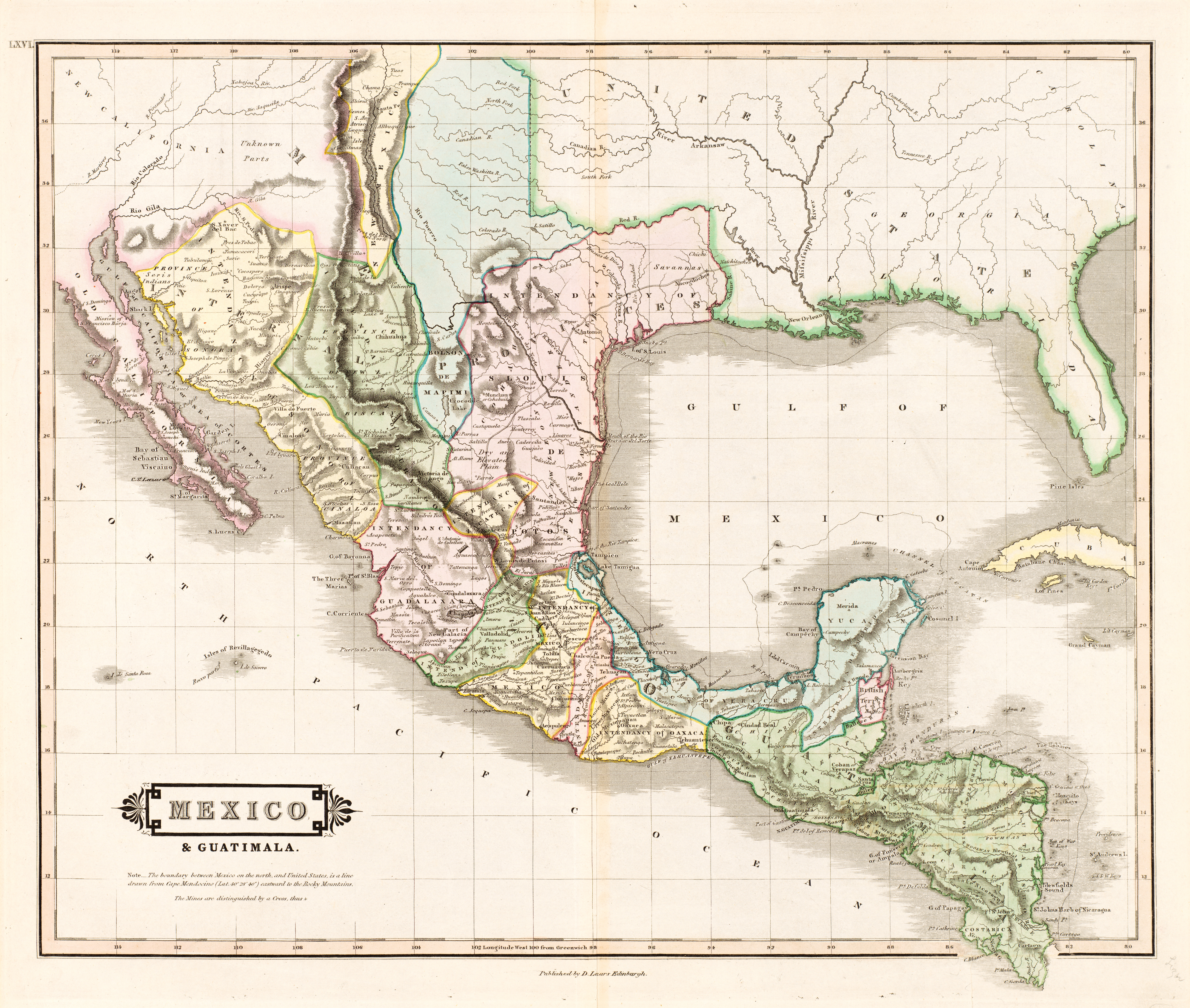
| Descripción | English: The creator of this map was probably Daniel Lizars II (1793-1875), the son of Edinburgh map engraver and publisher Daniel Lizars I (1754-1812) and younger brother of William Home Lizars (1788-1859). Shortly after producing the map, Daniel II went bankrupt in 1832 and emigrated to Canada in 1833. Lizars' map shows Mexico's administrative districts as Intendencies (Intendencias) and Internal Provinces (Provincias Internas) dating from the Spanish era. His depiction of the area that became Texas is notably jarring to modern viewers because his map further exaggerated some of the cartographic errors of his predecessors and contemporaries: particularly, a southerly "dip" of the middle Red River and the southerly courses of the Trinity, Brazos, and Colorado Rivers (which actually flow southeasterly). Settlements shown include Nacogdoches, "St." Antonio, and "Loredo". Interestingly, Lizars included the "British Territory" that became British Honduras or Belize. British logging settlements existed in the territory by the late eighteenth century and, although the British government had been hesitant to create a colony for fear of provoking the Spanish, settlers there were largely self-governing. | ||||||||||||||||||||||||||
| Fecha | hacia 1831 | ||||||||||||||||||||||||||
| Fuente | UTA Libraries Cartographic Connections: mapa / texto | ||||||||||||||||||||||||||
| Creador |
| ||||||||||||||||||||||||||
| Adquisición | English: The University of Texas at Arlington Libraries Special Collections, Gift of Virginia Garrett | ||||||||||||||||||||||||||
| Geotemporal data | |||||||||||||||||||||||||||
| Map location | México Guatemala Texas | ||||||||||||||||||||||||||
| Georeferencing | If inappropriate please set warp_status = skip to hide. | ||||||||||||||||||||||||||
| Bibliographic data | |||||||||||||||||||||||||||
| Publicación | The Edinburgh Geographical and Historical Atlas | ||||||||||||||||||||||||||
| Autor | John Hamilton | ||||||||||||||||||||||||||
| Lugar de publicación | Edimburgo Londres Dublín | ||||||||||||||||||||||||||
| Editorial | John Hamilton Whittaker, Treacher & Co. W. Curry, Jun. & Co. | ||||||||||||||||||||||||||
| Archival data | |||||||||||||||||||||||||||
| Colección |
| ||||||||||||||||||||||||||
| Dimensiones | altura: 42 cm; ancho: 51,5 cm | ||||||||||||||||||||||||||
| Técnica | grabado coloreado sobre papel | ||||||||||||||||||||||||||
| artwork-references | Worms, Laurence; Ashley Baynton-Williams (2011) British Map Engravers, Londres: Rare Book Society, pp. 406–409 | ||||||||||||||||||||||||||
| Otras versiones | |||||||||||||||||||||||||||
.jpg)
Licencia
 | This file was provided to Wikimedia Commons by the University of Texas at Arlington Libraries as part of a cooperation project. The University of Texas at Arlington Libraries is part of the University of Texas at Arlington, a public research university located in Arlington, Texas.
|
| Este material está en dominio público en los demás países donde el derecho de autor se extiende por 100 años (o menos) tras la muerte del autor. Esta obra está en el dominio público en los Estados Unidos porque fue publicada (o registrada con la Oficina del Derecho de Autor de los E.E. U.U.) antes del 1 de enero de 1929. | |
| Esta obra ha sido identificada como libre de las restricciones conocidas en virtud del derecho de autor, incluyendo todos los derechos conexos. | |
Historial del archivo
Haz clic sobre una fecha y hora para ver el archivo tal como apareció en ese momento.
| Fecha y hora | Miniatura | Dimensiones | Usuario | Comentario | |
|---|---|---|---|---|---|
| actual | 13:26 13 jul 2019 | | 6185 × 5238 (11,59 MB) | Michael Barera | == {{int:filedesc}} == {{Map |title = ''Mexico & Guatimala'' [sic] |description = {{en|The creator of this map was probably Daniel Lizars II (1793-1875), the son of Edinburgh map engraver and publisher Daniel Lizars I (1754-1812) and younger brother of William Home Lizars (1788-1859). Shortly after producing the map, Daniel II went bankrupt in 1832 and emigrated to Canada in 1833. Lizars' map shows Mexico's administrative districts as Intendencies (''Intendencias'') and In... |
Usos del archivo
La siguiente página usa este archivo:
Uso global del archivo
Las wikis siguientes utilizan este archivo:
- Uso en en.wikipedia.org
- Uso en hr.wikipedia.org
- Uso en sh.wikipedia.org