Archivo:Illinois District 4 2004.png

No se dispone de una resolución más alta.
Illinois_District_4_2004.png (380 × 379 píxeles; tamaño de archivo: 13 kB; tipo MIME: image/png)
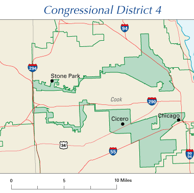
Illinois' 4th Congressional District, 108th Congress
Illustrates gerrymandering.
This map was obtained from an edition of the National Atlas of the United States. Like almost all works of the U.S. federal government, works from the National Atlas are in the public domain in the United States. Online access: NationalAtlas.gov | 1970 print edition: Library of Congress, Perry-Castañeda Library
|
Historial del archivo
Haz clic sobre una fecha y hora para ver el archivo tal como apareció en ese momento.
| Fecha y hora | Miniatura | Dimensiones | Usuario | Comentario | |
|---|---|---|---|---|---|
| actual | 09:03 26 jul 2005 | | 380 × 379 (13 kB) | Scott Ritchie | Illinois' 4th Congressional District, 108th Congress {{PD-self}} |
Usos del archivo
Las siguientes páginas usan este archivo:
Uso global del archivo
Las wikis siguientes utilizan este archivo:
- Uso en en.wikipedia.org
- Uso en eo.wikipedia.org
- Uso en fr.wikipedia.org
- Uso en ja.wikipedia.org
- Uso en no.wikipedia.org
- Uso en pt.wikipedia.org
- Uso en sv.wikipedia.org
- Uso en www.wikidata.org
- Uso en zh.wikipedia.org