Archivo:ChiosPrefecture.jpg


Tamaño de esta previsualización: 800 × 580 píxeles. Otras resoluciones: 320 × 232 píxeles · 640 × 464 píxeles · 1024 × 743 píxeles · 1278 × 927 píxeles.
Ver la imagen en su resolución original (1278 × 927 píxeles; tamaño de archivo: 109 kB; tipo MIME: image/jpeg)
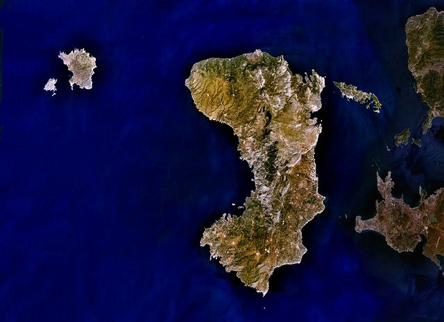
| Descripción | English: Public Domain composite satellite image of Chios Prefecture; consisting of the islands of Chios (centre), of Psara and Anti-Psara (West and far west), the Oinousses islands (East of Chios). Also includes Turkish mainland (East-shaded). Source: NASA World Wind. In some countries this is not legally possible; if so: |
| Fuente | Satellite imagery taken from NASA World Wind software (by screenshot) |
| Autor | Foto: NASA |
Licencia
| Esta imagen se encuentra en el dominio público porque es una captura de pantalla del software de globo terráqueo de la NASA, World Wind, que utiliza una capa de dominio público, como Blue Marble, MODIS, Landsat, SRTM, USGS o GLOBE.
|  |
Registro original de carga
Aquí se muestra la página de descripción original. Los siguientes nombres de usuario se refieren a en.wikipedia.
- 2007-07-07 19:02 AlekH 1278×927× (111297 bytes) Public Domain composite satellite image of Chios Prefecture; consisting of the islands of Chios (centre), of Psara and Anti-Psara (West and far west), the Oinousses islands (East of Chios). Also includes Turkish mainland (East-shaded). Source: NASA Wor
Historial del archivo
Haz clic sobre una fecha y hora para ver el archivo tal como apareció en ese momento.
| Fecha y hora | Miniatura | Dimensiones | Usuario | Comentario | |
|---|---|---|---|---|---|
| actual | 05:22 4 may 2009 | | 1278 × 927 (109 kB) | File Upload Bot (Magnus Manske) | {{BotMoveToCommons|en.wikipedia|year={{subst:CURRENTYEAR}}|month={{subst:CURRENTMONTHNAME}}|day={{subst:CURRENTDAY}}}} {{Information |Description={{en|Public Domain composite satellite image of Chios Prefecture; consisting of the islands of Chios (centre |
Usos del archivo
Las siguientes páginas usan este archivo:
Uso global del archivo
Las wikis siguientes utilizan este archivo:
- Uso en arz.wikipedia.org
- Uso en az.wikipedia.org
- Uso en ceb.wikipedia.org
- Uso en cs.wikipedia.org
- Uso en de.wikipedia.org
- Uso en de.wikivoyage.org
- Uso en el.wikipedia.org
- Uso en en.wikipedia.org
- Uso en eo.wikipedia.org
- Uso en fr.wikipedia.org
- Uso en gl.wikipedia.org
- Uso en hy.wikipedia.org
- Uso en incubator.wikimedia.org
- Uso en ka.wikipedia.org
- Uso en ko.wikipedia.org
- Uso en lv.wikipedia.org
- Uso en mk.wikipedia.org
- Uso en no.wikipedia.org
- Uso en pl.wiktionary.org
- Uso en ru.wikipedia.org
- Uso en sk.wikipedia.org
- Uso en sl.wikipedia.org
- Uso en sr.wikipedia.org
- Uso en th.wikipedia.org
- Uso en tr.wikipedia.org
- Uso en ur.wikipedia.org
- Uso en www.wikidata.org
- Uso en zh-yue.wikipedia.org
- Uso en zh.wikipedia.org