Umm as Sabaan
 From Wikipedia the free encyclopedia
This article includes a list of general references, but it lacks sufficient corresponding inline citations. (November 2019) |
Native name: جزيرة ام الصبان (Arabic) Nickname: Al Mohammediya | |
|---|---|
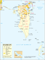
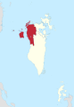
 Umm as Sabaan Island Location of Umm as Sabaan in Bahrain | |
| Geography | |
| Location | Persian Gulf |
| Coordinates | 26°12′00″N 50°26′10″E / 26.20°N 50.436°E |
| Archipelago | Bahrain |
| Adjacent to | Persian Gulf |
| Total islands | 1 |
| Major islands |
|
| Area | 0.18 km2 (0.069 sq mi) |
| Length | 0.9 km (0.56 mi) |
| Width | 0.28 km (0.174 mi) |
| Coastline | 2.5 km (1.55 mi) |
| Highest elevation | 5 m (16 ft) |
| Administration | |
| Governorate | Northern Governorate |
| Largest settlement | Umm as Sabaan (pop. 10) |
| Demographics | |
| Demonym | Bahraini |
| Population | 3 (2016) |
| Pop. density | 16.6/km2 (43/sq mi) |
| Ethnic groups | Bahraini, non-Bahraini |
| Additional information | |
| Time zone | |
| ISO code | BH-14 |
| Official website | www |
Umm as Sabaan (Arabic: ام الصبان) is an islet in Bahrain. It lies off the north western corner of Bahrain Island, near Budaiya village, and east of Jidda Island, located in the Persian Gulf. It lies 15 km (9.3 mi) west of the capital, Manama, on Bahrain Island.
History[edit]
The island was privately owned by Sheikh Mohammed bin Salman Al Khalifa, uncle of the present King, Hamad bin Isa al Khalifa, and brother of Prime Minister Khalifa bin Salman Al Khalifa. Sheikh Mohammed renamed the island after himself as Al Mohammediya (Arabic: المحمدية).
In the 1930s, the ruler of Bahrain lent the island as a gift to Max Thornburg, an American oil executive from Caltex. He cultivated the northern part of the island and lived with his wife there many months every year. In 1958, the Thornburgs returned the island.[1]
Administration[edit]
The island belongs to Northern Governorate.
Image gallery[edit]
-
 Map 1
Map 1 -
 District Map


See also[edit]
References[edit]
- ^ Ward, Philip (1993). Bahrain A Travel Guide. The Oleander Press. p. 157. ISBN 9780906672211.
- Islands And Maritime Boundaries Of The Gulf 1798–1960, Archive Editions
- Personal diary of Charles D. Belgrave, British Advisor to the ruler of Bahrain, 1926 - 1957
- Article about politics of the islands, Abbas al Murshid
This Bahrain location article is a stub. You can help Wikipedia by expanding it. |