Thakurgaon District
 From Wikipedia the free encyclopedia
Thakurgaon ঠাকুরগাঁও | |
|---|---|
| Thakurgaon District | |
     Clockwise from top-left: Balia Mosque, Haripur Rajbari, Dholpur Temple, Gondor River, Jamalpur Jamia Masjid | |
 Location of Thakurgaon District in Bangladesh | |
 Expandable map of Thakurgaon District | |
| Coordinates: 25°57′N 88°15′E / 25.95°N 88.25°E | |
| Country | |
| Division | Rangpur Division |
| Government | |
| • Deputy Commissioner | K.M. Kamaruzzaman Selim |
| Area | |
| • Total | 1,781.74 km2 (687.93 sq mi) |
| Population (2022 census)[1] | |
| • Total | 1,533,894 |
| • Density | 860/km2 (2,200/sq mi) |
| Time zone | UTC+06:00 (BST) |
| Postal code | 5100 |
| HDI (2018) | 0.614[2] medium · 7th of 21 |
Thakurgaon (Bengali: ঠাকুরগাঁও জেলা, Thakurgaon Jela also Thakurgaon Zila) is a district in northwestern Bangladesh. It is part of the Rangpur Division and borders India to the west.[3] It was established as a mahakuma in 1860 consisting of 6 thanas named Thakurgaon sadar, Baliadangi, Pirganj, Ranishankail, Haripur and Ruhia. In 1947, it was re-established as a mahakuma including 3 thanas of Jalpaiguri and a thana of kochbihar of India. In 1981, Atoari was included in the new Panchagarh district and the area was shrunk in just 5 thanas. It was established as a district on 1 February 1984.[4]
Subdistricts[edit]
There are 5 upazilas, 6 thanas, 53 unions, 647 mouzas and 1,016 villages in Thakurgaon. The Upazilas in the district are:
There is also an upazila named Pirganj under Rangpur district.
Etymology[edit]
While there was no concrete evidence that Thakurgaon was once named Nishchintapur, assumptions were made based on the similarity between the names. The mausoleum and the name Nukchintapur were considered as potential references to Thakurgaon's earlier name, Nischintinpur. Yet, confirmation came when historical maps from the 17th century depicted two distinct locations: Atitkurgaon and Nishchintpur. Nishchintpur was positioned at the eastern end of Tanganni and partly on the west side of the Tangan river in the north-west. Thakurgaon was situated from the 4th to the 4th, indicating that the name of Thakurgaon's sadar was originally Nishchinpura at the eastern end of the Tangan river. Over time, Nishchinpura evolved into Thakurgaon, encompassing the entire subdivision initially known as Thathakuranga and later adopting the identity of the district.
Historical records reveal that the current district headquarters of Thakurgaon has its roots in a location 8 kilometers north of Akecha Union, where two brothers named Narayan Chakraborty and Satish Chakraborti resided. Known for their wealth and influence, the locals referred to their house as Thakurbari. Chakrabarti house eventually lent its name to the area, transitioning from Thakurbari to Thakurgaon. Recognizing the need for a police station, the Chakrabarti brothers sought approval from the British government, leading to the establishment of a police station in the early 1800s, named Thakurgaon thana. Subsequently, the thana was relocated to the Tangon river due to various reasons, and in 1860, Thakurgaon subdivision was formed with 10 thanas. The district, officially named Thakurgaon with five thanas, was marked on the map of Bangladesh on February 1, 1984. Despite its recent establishment as a district, the region boasts an ancient history and cultural significance. [5]
History[edit]

During British rule Thakurgaon was a tehsil (a district subdivision). In 1947 at the time of the Partition of India, Thakurgaon Subdivision became part of the newly established Dinajpur District of East Bengal. In 1984 Thakurgaon subdivision was split off Dinajpur and became a separate district (i.e. Thakurgaon District). Before 1879 Thakurgaon District was ruled my Maithil Brahmin and Thakurs like Bikhash Jha, Barun Thakur and Vidhenesh Roy. Until 1947 Thakurgaon district had a just Hindu majority population of 52%. Most people believe Thakurgaon district has got its name from Barun Thakur.
During the British period in 1800, a Tagore family initiative led to the formation of Thangur, Shuk, Kulik, Patharaj, and Dhapa widows near the present municipality area. This gave rise to the Thakurgaon Thana, named after these entities. In 1860, it was declared as a sub-division with six police stations. In 1947, Thakurgaon became a subdivision, absorbing 10 thanas from Jalpaiguri district and one from Kotwihar. However, in 1981, Thakurgaon's geographical boundaries changed, resulting in five thanas in a separate Panchagarh district.[6]
Ethnography[edit]
The ethnographic makeup of the Thakurgaon district population shares similarities with the broader characteristics of Bangladesh. However, due to the diverse composition of this township's population, a multitude of ethno-characteristics are evident. Notably, the district hosts significant numbers of the three main language groups in the Indian subcontinent: Indo-European, Dravidian, and Munda. Additionally, a considerable population belonging to the 'Bodo' language group has established itself in the district.
The demographic landscape of Thakurgaon encompasses Hindu and Muslim majorities, along with communities such as Santal, Munda, Onrao, Koch, Polia, Rajvanshi, Ho, Mahto, Malo, Kukamar, Hari, Bhuiyan, Gangkhu, among others. The ethnographic foundation of Thakurgaon district is shaped by the amalgamation of these diverse groups.
The populations of Bangladesh exhibit varied physical traits, including long mouths, broad noses, and fall into three main categories: Longmund, Long and Middle Nasa, Egypto-Asiatic or Melanid, and specifically Golmund, Advanced Nasa, Alpine or Eastern Brachyd. [7]
Geography[edit]
The area of Thakurgaon is 1,781.74 square kilometres (687.93 sq mi). Thakurgaon is in the north west corner of Bangladesh, it is about 467 km from Dhaka, the capital of Bangladesh. It is surrounded by Dinajpur district on its south, Panchagarh district to the east and India on its west and north sides, it is a part of the Himalayan plain land. Highest average temperature of this district is 33.5 °C and lowest average is 10.05 °C.[8]
Demographics[edit]
| Year | Pop. | ±% p.a. |
|---|---|---|
| 1974 | 633,331 | — |
| 1981 | 817,732 | +3.72% |
| 1991 | 1,010,948 | +2.14% |
| 2001 | 1,214,376 | +1.85% |
| 2011 | 1,390,042 | +1.36% |
| 2022 | 1,533,894 | +0.90% |
| Sources:[9] | ||
According to the 2022 Census of Bangladesh, Thakurgaon District had 382,400 households and a population of 1,533,894, 18.6% of whom lived in urban areas. The population density was 861 people per km2. The literacy rate (age 7 and over) was 74.3%, compared to the national average of 74.7%.[1]
| Religion | Population (1941)[10]: 88–89 | Percentage (1941) | Population (2011)[9] | Percentage (2011) |
|---|---|---|---|---|
| Islam | 183,554 | 53.96% | 1,066,176 | 76.70% |
| Hinduism | 150,366 | 44.20% | 309,423 | 22.26% |
| Tribal religion | 5,627 | 1.65% | 6,283 | 0.45% |
| Christianity | 453 | 0.13% | 7,897 | 0.57% |
| Others [b] | 181 | 0.06% | 263 | 0.02% |
| Total Population | 340,181 | 100% | 1,390,042 | 100% |
Muslims make up 76.70% of the population, while Hindus are 22.26% and Christians 0.57% of the population.[9]
Economy[edit]
In Bangladesh, agriculture serves as the foundation of the economy, and Thakurgaon has long been striving for economic productivity, with agriculture playing a significant role in the district's economy. Thakurgaon produces a variety of agricultural products, including rice, wheat, sugarcane, seasonal vegetables, and fruits. The sugarcane plantation, known as TSM (Thakurgaon Sugar Mill), is part of the BSFIC, becoming a primary source of livelihood for the locals. Poultry farms are a thriving business in Thakurgaon, and the district is equipped with several cold stores. Various businesses focused on the production and repair of agricultural tools have also emerged in the area.
The contribution of Non-Governmental Organizations (NGOs) in the rural economy of Thakurgaon has been significant. Notably, organizations like ESDO and RDRS have received widespread acclaim for their efforts in poverty alleviation, particularly in enhancing the income and employment prospects of both men and women in Thakurgaon. RDRS, particularly in the immediate aftermath of independence, garnered praise for its relief and rehabilitation activities, while ESDO's initiatives in micro-credit, child education, literacy, and integrated community development since the 90s have generated substantial employment opportunities for the economically disadvantaged, especially women. Moreover, the proactive measures taken by NGOs in promoting social and health awareness have played a pivotal role in contributing to the overall economy of the region.[11]
However, the community's distance from the capital poses challenges in obtaining adequate technical and logistical support and in transporting local products to the national market. It is not easy for investors to establish businesses far away from the center of national trade and commerce. Despite these challenges, Thakurgaon is experiencing rapid development. Some business groups, such as the Younis Group and Kazi Farm, have initiated investments in Thakurgaon. With these developments, the agriculture-based district is expected to transform into an industrial hub in the near future.
Places of interest[12][edit]

There are various places of interest in the district, these include:
- The Tangon River
- Senua Bridge
- Old Airport, destroyed during the second world war, situated at Modergonj beside of Arazipaickpara
- Jomidar Mosjid at Shibganj
- Balia Mosjid at Balia Union
- The Fair of Nekmordon
- Ramrai Dighi, it is a pond having 50 acres (200,000 m2) of area. A beautiful tourist spot.
- King's Palace
- The river of Kulik
- Khunia Dhighi Memorial
- Palace of King Tonko Nath
- Gorkoi Heritage
- 500 acre shal garden on the bank of the Tangon River
- Horinmari Amgach (Stand by 3 bigha area )
- Haripur Rajbari
- Gorokkhonath temple
- Ranishankail Jomidar Bari
- Jagdal Rajbari
- Sangah Shahi mosque
- Fatehpur mosque
- Shalbari mosque
- Bhulli badh
- Burir bad
- Mujabarni Sarkarpara
Culture[13][edit]
Religious and cultural diversity in Thakurgaon is evident through a variety of festivals celebrated by the Muslim and Hindu communities. Muslims observe ceremonies such as Eid-al-Fitr, Eid-al- Azha, Miladunnabi, Muharram (Ashura), and Shab-e- Barat. Meanwhile, Hindus partake in numerous pujas, including Durga Puja, Kali Puja, Lakshmi Puja, Bhiphunda, Saraswati Puja, Chadak Puja, Rasajatra, Doljatra, and Janmastami. Additionally, New Year celebrations, Nabanna, and Paush Sankranti are embraced by all communities.
The Milad ceremony among Muslims marks auspicious beginnings and joyful news. Notably, significant occasions like Eid, Durgapuja, Laxmi Puja, Saraswati Puja witness the harmonious interaction between Hindus and Muslims, as both communities visit each other's courtrooms and extend invitations. Moreover, celebrations such as marriages, Akika, Khatna, birthdays, Annaprashan, and more are occasions where people from diverse religious backgrounds come together. Thakurgaon exemplifies a community where religion does not serve as a barrier.
Beyond religious festivals, certain cultural practices have become ingrained in the local folk culture. Enjoying bread or rice in the evening, playing traditional musical instruments or participating in Tazia processions are not confined to specific religious festivals; instead, they have evolved to become integral parts of the region's cultural tapestry. On the occasion of the New Year, engaging in bird and fish hunting, sharing meals with fellow community members, consuming traditional foods like nuts and betel leaves, and partaking in cultural activities are common practices embraced by people of all backgrounds in Thakurgaon.[13]
In bygone eras, Thakurgaon saw the widespread use of traditional utensils crafted from materials such as pottery, including dishes, lids, tawas, gastars, and items like Dixie, karail, bowls, glasses, spoons, iron pans, and bamboo lacaris or clay lahhi, dies, or duars for pulses. These age-old utensils are still in use today. However, the culinary landscape has evolved over time, witnessing the prevalence of tin, subsequently steel, and, in contemporary times, melamine utensils among the general populace. Glass and chinaware adorn the tables of esteemed households, adding to the overall dining experience. Traditional spice grinding tools, such as stone shilpatas or Haman dithas, were once commonplace and are still retained.
In rural settings, rice was traditionally pounded in potholes or chham-gahins. Women in impoverished families not only ground rice for their own consumption but also received remuneration in the form of additional rice or other essentials. This practice enabled them to create items like chira, mudi, khaoi, serving as a vital means of sustenance for many disadvantaged women. However, this once-thriving profession has gradually diminished, with the advent of electricity leading to the establishment of numerous small and large rice mills in villages.
Today, the market serves as a primary source for obtaining rice, chilis, twigs, rice flour, and spices such as green chili, and turmeric powder. Consequently, women who were previously engaged in rice processing have transitioned into roles as agricultural laborers, reflecting the changing dynamics of livelihoods in Thakurgaon.[14]
There is a versatile practice of culture in the district; few festivals and cultural events are regularly arranged there. Alpona Sansad arranges Boishakhi Mela in every Bangla new year. Held "Eid Fair" at the occasion of Eid-Ul-Adha & Eid-Ul-Fitre every year at Thakurgaon Boro Matth also. Several drama clubs (Sapla Natto Gosty-Estd.1974, Nischintopur Theater-1983 etc. ) practice and perform regularly and stage original and famous dramas every month. Dhamer Gaan is a unique traditional cultural invention of Thakurgaon people. The existing 10 tribes in this area enjoy their own heritage and cultural practices.

Notable people[edit]
- Mirza Fakhrul Islam Alamgir Former member of the parliament and Secretary general of Bangladesh Nationalist Party
- Ramesh Chandra Sen Member of parliament
- Shishir Bhattacharjee Painter, cartoonist
- Litu Anam Actor and Television personality
- Dabirul Islam 7-term Member of parliament of Awami league
- Shirin Akter Shila Model and beauty pageant
Gallery[edit]
-
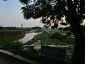
 Shuk River at Thakurgaon Sadar Upazila
 -
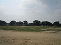 Playground of Thakurgaon
 -
 Tangon River from Tangon Bridge
 -
 Kulik River at westside of Ranisankail Upazila
 -
 Amai Pond at Haripur Upazila parishad
 -
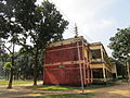 A science building of Thakurgaon Govt. College.


See also[edit]
Notes[edit]
- ^ Thakurgaon, Baliadangi, Ranisankail, Haripur and Pirganj thanas of Dinajpur district
- ^ Including Jainism, Buddhism, Zoroastrianism, Judaism, Ad-Dharmis, or not stated
References[edit]
- ^ a b Population and Housing Census 2022: Preliminary Report. Bangladesh Bureau of Statistics. August 2022. pp. viii, 28, 30, 39, 44, 46. ISBN 978-984-35-2977-0.
- ^ "Sub-national HDI - Area Database - Global Data Lab". hdi.globaldatalab.org. Retrieved 18 March 2020.
- ^ Abu Md. Iqbal Rumi Shah (2012). "Thakurgaon District". In Sirajul Islam and Ahmed A. Jamal (ed.). Banglapedia: National Encyclopedia of Bangladesh (Second ed.). Asiatic Society of Bangladesh.
- ^ "History of Thakurgaon". Bangladesh national portal.
- ^ "Name of the source: Nishchintapur to Thakurgaon". www.thakurgaon.gov.bd. Retrieved 22 January 2024.
- ^ "Thakurgaon District". www.thakurgaon.gov.bd. Retrieved 22 January 2024.
- ^ "নৃতাত্ত্বিক বৈশিষ্ঠ্য". www.thakurgaon.gov.bd. Retrieved 22 January 2024.
- ^ "Thakurgaon at a glance". Bangladesh national portal.
- ^ a b c d "Bangladesh Population and Housing Census 2011 Zila Report – Thakurgaon" (PDF). Bangladesh Bureau of Statistics.
- ^ "Census of India, 1941 Volume VI Bengal Province" (PDF).
- ^ "Trade and commerce of Thakurgaon". www.thakurgaon.gov.bd. Retrieved 22 January 2024.
- ^ "Notable places of Thakurgaon". Bangladesh national portal.
- ^ a b "District Tradition". www.thakurgaon.gov.bd. Retrieved 22 January 2024.
- ^ "District tradition". www.thakurgaon.gov.bd. Retrieved 22 January 2024.
| Barisal Division |  | |
|---|---|---|
| Chittagong Division | ||
| Dhaka Division | ||
| Khulna Division | ||
| Mymensingh Division | ||
| Rajshahi Division | ||
| Rangpur Division | ||
| Sylhet Division | ||
| International | |
|---|---|
| National | |
| Geographic | |