Shire of Bruce Rock
 From Wikipedia the free encyclopedia
| Shire of Bruce Rock Western Australia | |||||||||||||||
|---|---|---|---|---|---|---|---|---|---|---|---|---|---|---|---|
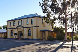
 The state heritage listed Bruce Rock shire offices, 2014 | |||||||||||||||
 Location in Western Australia | |||||||||||||||
 | |||||||||||||||
| Population | 979 (LGA 2021)[1] | ||||||||||||||
| Established | 1913 | ||||||||||||||
| Area | 2,726.9 km2 (1,052.9 sq mi) | ||||||||||||||
| Shire President | Stephen Strange | ||||||||||||||
| Council seat | Bruce Rock | ||||||||||||||
| Region | Wheatbelt | ||||||||||||||
| State electorate(s) | Central Wheatbelt | ||||||||||||||
| Federal division(s) | Durack | ||||||||||||||
 | |||||||||||||||
| Website | Shire of Bruce Rock | ||||||||||||||
| |||||||||||||||
The Shire of Bruce Rock is a local government area in the Wheatbelt region of Western Australia, about 50 kilometres (31 mi) south of Merredin and about 250 kilometres (155 mi) east of the state capital, Perth. The Shire covers an area of 2,727 square kilometres (1,053 sq mi), and its seat of government is the town of Bruce Rock.
History[edit]
Bruce Rock was initially constituted as the East Avon Road District in 1913. In 1918, it was renamed to Bruce Rock, and on 1 July 1961, it became a shire following the enactment of the Local Government Act 1960. In 1999, the Ardath, Babakin, Kwolyin, Shackleton, Belka and Coordarin wards covering outlying areas of the Shire were replaced by 2-member South, West and East Wards, while the Central and Town wards covered other areas. Wards were abolished for the 2005 elections.[2]
Wards[edit]
The Shire is no longer divided into wards and the eleven councillors represent the entire Shire.
Towns and localities[edit]
The towns and localities of the Shire of Bruce Rock with population and size figures based on the most recent Australian census:[3][4]
| Locality | Population | Area | Map |
|---|---|---|---|
| Ardath | 51 (SAL 2021)[5] | 358.2 km2 (138.3 sq mi) |  |
| Babakin | 56 (SAL 2021)[6] | 381.5 km2 (147.3 sq mi) |  |
| Bruce Rock | 742 (SAL 2021)[7] | 1,108.2 km2 (427.9 sq mi) |  |
| Kwolyin | 20 (SAL 2021)[8] | 343.1 km2 (132.5 sq mi) |  |
| Shackleton | 114 (SAL 2021)[9] | 533.8 km2 (206.1 sq mi) |  |
Former towns[edit]
Population[edit]
|
|
Heritage-listed places[edit]

As of 2023, 210 places are heritage-listed in the Shire of Bruce Rock,[10] of which four are on the State Register of Heritage Places.[11]
References[edit]
- ^ Australian Bureau of Statistics (28 June 2022). "Bruce Rock (Local Government Area)". Australian Census 2021 QuickStats. Retrieved 28 June 2022.
- ^ WA Electoral Commission, Municipality Boundary Amendments Register (release 3.0), 31 May 2007.
- ^ "SLIP Map". maps.slip.wa.gov.au. Landgate. Retrieved 5 February 2023.
- ^ "NationalMap". nationalmap.gov.au. Geoscience Australia. Retrieved 5 February 2023.
- ^ Australian Bureau of Statistics (28 June 2022). "Ardath (suburb and locality)". Australian Census 2021 QuickStats. Retrieved 28 June 2022.
- ^ Australian Bureau of Statistics (28 June 2022). "Babakin (suburb and locality)". Australian Census 2021 QuickStats. Retrieved 28 June 2022.
- ^ Australian Bureau of Statistics (28 June 2022). "Bruce Rock (suburb and locality)". Australian Census 2021 QuickStats. Retrieved 28 June 2022.
- ^ Australian Bureau of Statistics (28 June 2022). "Kwolyin (suburb and locality)". Australian Census 2021 QuickStats. Retrieved 28 June 2022.
- ^ Australian Bureau of Statistics (28 June 2022). "Shackleton (suburb and locality)". Australian Census 2021 QuickStats. Retrieved 28 June 2022.
- ^ "Shire of Bruce Rock Heritage Places". inherit.stateheritage.wa.gov.au. Heritage Council of Western Australia. Retrieved 25 February 2023.
- ^ "Shire of Bruce Rock State Register of Heritage Places". inherit.stateheritage.wa.gov.au. Heritage Council of Western Australia. Retrieved 25 February 2023.
External links[edit]
![]() Media related to Shire of Bruce Rock at Wikimedia Commons
Media related to Shire of Bruce Rock at Wikimedia Commons