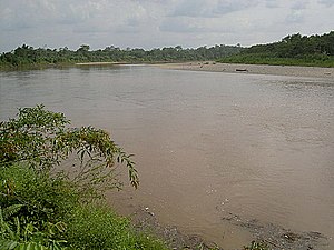
San Miguel River (Colombia)
 From Wikipedia the free encyclopedia
| San Miguel River | |
|---|---|
 | |
| Native name | Río San Miguel (Spanish) |
| Location | |
| Countries | |
| Physical characteristics | |
| Source | Andes Mountains |
| • location | Nariño Department |
| • elevation | 3,000 m (9,800 ft) |
| Mouth | Putumayo River |
• location | Puerto El Carmen de Putumayo, Colombia |
• coordinates | 0°07′05″N 75°52′02″W / 0.11806°N 75.86722°W |
| Length | 295 km (183 mi) |
| Discharge | |
| • location | mouth |
The San Miguel River (Spanish: Río San Miguel) is a river in Colombia and Ecuador. It is a sub-tributary of the Solimões River (middle course of the Amazon) via the Putumayo River.
Geography[edit]
The San Miguel River rises on the slopes of the Andes Mountains, in the extreme south of the Colombian department of Nariño, on the border between Colombia and Ecuador.[1] It then flows east, marking the border between the two countries, before passing through Ecuador and then joining the Putumayo River, again on the border.[2]
References[edit]
- ^ "Río San Miguel: Todo lo que necesita saber sobre él". riosdelplaneta.com (in Spanish). Rios del planeta. Archived from the original on 24 January 2022. Retrieved 22 August 2018.
- ^ Collectif (2003). Definicion de Areas Para la Siera de Camru Camu en El Departamento de Putumayo (in Spanish). Corpoica. p. 115. ISBN 958-97143-2-3. Retrieved 22 August 2018..