Salvatore de Pilestrina
 From Wikipedia the free encyclopedia

Salvatore de Pilestrina (fl. 1502–1533), also known as Salvat de Pilestrina, was a mapmaker in Mallorca in the early 16th century.
Scholars suggest he was of Italian origin, in part because his work combines Italian and Catalan mapmaking techniques of the period.[1][2] He likely traveled from Italy to Mallorca to study cartography there.[3]
His known period of activity spans from 1502 to 1533.[4][5]
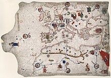
Pilestrina is known for his work on portolan charts, and he was active with the Majorcan cartographic school.[6][4][5] He created several significant maps of the Mediterranean, the originals of which have been lost.[1] He is also thought to have produced a number of other maps that extended to the Americas, including a map of the Atlantic coast of Central America.[7][8]
His first known chart was a major world map, produced around 1503.[3][9][10] Other known works were produced in 1504 or 1505,[11] in 1511,[12][13] and in 1533.[1][4][14] While other maps have been attributed to him, their origins are contested by historians.[15]
References[edit]
- ^ a b c Astengo, Corradino (1987). "The Renaissance Chart Tradition in the Mediterranean". In Harley, J. B.; Woodward, David; Monmonier, Mark S. (eds.). The History of Cartography (PDF). Vol. 3. Chicago: University of Chicago Press. ISBN 0-226-31633-5. OCLC 13456456.
- ^ Winter, Heinrich (1947-01-01). "On the real and the Pseudo‐Pilestrina maps and other early‐Portuguese maps in Munich". Imago Mundi. 4 (1): 25–27. doi:10.1080/03085694708591877. ISSN 0308-5694.
- ^ a b Bagrow, Leo; Skelton, R.A. History of cartography (Enlarged second ed.). London. ISBN 978-1-351-51558-0. OCLC 995849708.
- ^ a b c "Portolan chart by Salvat de Pilestrina". Ziereis Facsimiles. Retrieved 2021-02-08.
- ^ a b Rey Pastor, Julio; García Camarero, Ernesto (1959). La Cartografía Mallorquína (PDF) (in Spanish). Departamento de Historia y Filosofía de la Ciencia Instituto Luis Vives Consejo Superior de Investigaciones Científicas.
- ^ "Salvatore de Pilestrina (14..-1511)". Bibliothèque nationale de France (in French). Retrieved 2021-02-08.
- ^ "[Atlantic coast of Central America]". Library of Congress. Retrieved 2021-02-08.
- ^ Lewis, Bessie Mary (1936). "Darient – A Symbol of Defiance and Achievement". The Georgia Historical Quarterly. 20 (3): 185–198. ISSN 0016-8297. JSTOR 40576444.
- ^ Paltsits, Victor Hugo; Stevenson, Edward Luther (July 1905). "Maps Illustrating Early Discovery and Exploration in America, 1502-1530". The American Historical Review. 10 (4): 863. doi:10.2307/1834492. ISSN 0002-8762. JSTOR 1834492.
- ^ List of Maps of the World: Illustrating the Progress of Geographical Knowledge from the Earliest Times to the End of the Seventeenth Century. New York Public Library. 1904.
- ^ Heawood, Edward (1923). "A Hitherto Unknown World Map of A. D. 1506". The Geographical Journal. 62 (4): 279–293. doi:10.2307/1781021. ISSN 0016-7398. JSTOR 1781021.
- ^ Boinet, A. (1925). "Courrier de France". La Bibliofilía. 27 (1/2): 61–71. ISSN 0006-0941. JSTOR 26208950.
- ^ Van Duzer, Chet (2007). "Cartographic Invention: The Southern Continent on Vatican MS Urb. Lat. 274, Folios 73v-74r (c.1530)". Imago Mundi. 59 (2): 193–222. ISSN 0308-5694. JSTOR 40234167.
- ^ "[Carta de marear del mar Mediterráneo]". Biblioteca Nacional de España (in Spanish). Retrieved 2021-02-08.
- ^ Winsor, Justin (1884). Narrative and critical history of America, ed. by Justin Winsor.