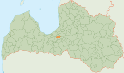
Salaspils Municipality
 From Wikipedia the free encyclopedia
Salaspils Municipality Salaspils novads | |
|---|---|
 | |
| Country | |
| Formed | 2004 |
| Centre | Salaspils |
| Government | |
| • Council Chair | Raimonds Čudars (V) |
| Area | |
| • Total | 122.81 km2 (47.42 sq mi) |
| • Land | 100.01 km2 (38.61 sq mi) |
| • Water | 22.8 km2 (8.8 sq mi) |
| Population (2023)[2] | |
| • Total | 23,451 |
| • Density | 190/km2 (490/sq mi) |
| Website | www |
Salaspils Municipality (Latvian: Salaspils novads) is a municipality in Vidzeme, Latvia. The municipality was formed in 2004 by reorganization of Salaspils town and its rural territory, the administrative centre being Salaspils. In 2010 the rural territory was renamed Salaspils parish. The population in 2020 was 22,758.[3]
Twin towns — sister cities[edit]
Patron of the University of Latvia[edit]
Salaspils municipality is a silver patron of the University of Latvia Foundation. Has been supporting the University of Latvia since 2013, when a scholarship was established to support young people in their region who start basic studies in one of Latvia's higher education institutions, fulfilling the criteria, support is provided throughout the basic studies.[4]
 Finspång, Sweden
 Finsterwalde, Germany
 Wieliszew, Poland
See also[edit]
References[edit]
- ^ "Reģionu, novadu, pilsētu un pagastu kopējā un sauszemes platība gada sākumā". Central Statistical Bureau of Latvia. Retrieved 18 January 2023.
- ^ "Iedzīvotāju skaits pēc tautības reģionos, pilsētās, novados, pagastos, apkaimēs un blīvi apdzīvotās teritorijās gada sākumā (pēc administratīvi teritoriālās reformas 2021. gadā) 2021 - 2022". Central Statistical Bureau of Latvia. Retrieved 2 October 2023.
- ^ "ISG020. Population number and its change by statistical region, city, town, 21 development centres and counties". Central Statistical Bureau of Latvia. 2020-01-01. Retrieved 2021-02-12.
- ^ "Salaspils novada pašvaldība".
- ^ "Sadraudzības pilsētas". salaspils.lv (in Latvian). Salaspils. Retrieved 2019-08-31.
External links[edit]
 Media related to Salaspils Municipality at Wikimedia Commons

