Mount Gharat
 From Wikipedia the free encyclopedia
| Mount Gharat (Mount Garet) | |
|---|---|
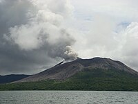
 Mount Gharat and Lake Letas | |
| Highest point | |
| Elevation | 797 m (2,615 ft)[1] |
| Prominence | 797 m (2,615 ft) |
| Coordinates | 14°16′S 167°30′E / 14.27°S 167.5°E[1] |
| Geography | |
 Mt Garet, in the middle of Gaua island | |
| Location | Gaua, Banks Islands, Vanuatu |
| Geology | |
| Mountain type | Somma-Stratovolcano |
| Last eruption | 2011[1] |
Mount Gharat or Mount Garet (797 m), a somma volcano, is the highest peak on the volcanic island of Gaua of the Banks Islands in northern Vanuatu.
Geography[edit]
The peak is located at the centre of the island, is volcanically active and is surrounded by Lake Letas on all sides except the southwest.
-
 Eruption of Mt Garet in Sept 2010.
 -
 2013 satellite picture of Mt Garet during eruption


Name[edit]
The volcano has slightly different names, depending on which of the local languages is being considered. It is known as Garet [ɣaˈrɛt] in Nume, Grāt [ɣraːt] in Dorig, Gerät [ɣɛˈrɛ͡at] in Koro, Gäräs [ɣæˈræs] in Lakon. The spelling Gharat found sometimes on maps is an attempt at transcribing Mota or Olrat Garat [ɣarat].
All these names come from a Proto-Torres-Banks form *ɣarati, whose literal meaning is “itching, burning” ‒ perhaps in relation to the volcano's toxic fumes.
References[edit]
- ^ a b c "Gaua". Global Volcanism Program. Smithsonian Institution. Retrieved 2020-08-29.