Mangart
 From Wikipedia the free encyclopedia
| Mangart | |
|---|---|
| Mangrt | |
 | |
| Highest point | |
| Elevation | 2,679 m (8,789 ft) |
| Prominence | 1,065 m (3,494 ft)[1] |
| Isolation | 12.7 km (7.9 mi) |
| Listing | Alpine mountains 2500-2999 m |
| Coordinates | 46°26′24″N 013°39′14″E / 46.44000°N 13.65389°E |
| Geography | |
 Mangart Location in the Alps | |
| Location | Slovenia - Italy |
| Parent range | Julian Alps |
| Climbing | |
| First ascent | 1794 |
Mangart or Mangrt is a mountain in the Julian Alps, located on the border between Italy and Slovenia. With an elevation of 2,679 metres (8,789 ft), it is the third-highest peak in Slovenia, after Triglav and Škrlatica. It was first climbed in 1794 by the naturalist Franz von Hohenwart. Mangart is also the name of the mountain range between the Koritnica Valley and the Mangart Valley, with the highest peak called Veliki Mangart (Big Mount Mangart).
Name[edit]
Mount Mangart was attested in historical sources in 1617 as Monhart. The name is of German origin, derived from the personal name Mainhart (from Old High German Maganhard). In addition to serving as the name of the mountain, this German name has also developed into Slovene surnames such as Manhart and Menart.[2]
Access[edit]
The road to Mangart Saddle (Slovene: Mangartsko sedlo; 2,072 metres or 6,798 feet) is the highest road in Slovenia.[3] The Mangart Pass Lodge is located at the western foot of Mangart. There are two lakes under Mangart's northern face.
-
 Mangart Saddle Lodge
 -
 Mangart in winter
 -
 Mangart Pass seen from the Via Ferrata trail
 -
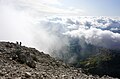 Hikers approaching the top of Mangart; view toward the southwest
 -
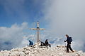 The peak of Mangart

.jpg)


References[edit]
- ^ "Mangart - peakbagger". peakbagger.com. Retrieved 13 February 2015.
- ^ Snoj, Marko (2009). Etimološki slovar slovenskih zemljepisnih imen. Ljubljana: Modrijan. p. 252.
- ^ Velkovrh, Ciril (2004). "Veliki vrhovi na zemljevidih Atlasa Slovenije" [Veliki Vrh on the Maps of the Atlas of Slovenia] (PDF). Geodetski Vestnik (in Slovenian). 48 (1). Association of Geodesists: 108–110. ISSN 0351-0271.