Madhupur Upazila
 From Wikipedia the free encyclopedia
You can help expand this article with text translated from the corresponding article in Bangla. (December 2019) Click [show] for important translation instructions.
|
Madhupur মধুপুর | |
|---|---|
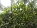
 Lake in Madhupur National Park | |
.svg) | |
| Coordinates: 24°37′N 90°1.5′E / 24.617°N 90.0250°E | |
| Country | |
| Division | Dhaka |
| District | Tangail |
| Parliamentary Area | Tangail-1 |
| Area | |
| • Total | 366.92 km2 (141.67 sq mi) |
| Population (2011) | |
| • Total | 296,729 |
| • Density | 810/km2 (2,100/sq mi) |
| Time zone | UTC+6 (BST) |
| Website | madhupur |
Madhupur (Bengali: মধুপুর) is an upazila of Tangail District[1] in the Division of Dhaka, Bangladesh.
Geography[edit]
Madhupur is located at 24°37′00″N 90°01′30″E / 24.6167°N 90.0250°E. It has 75,903 households and total area of 366.92 km2. It has a large forest area named 'Madhupurer Gor". Madhupur is famous throughout the country for delicious pineapples. Madhupur is bounded by Jamalpur Sadar upazila on the north, Gopalpur and Ghatail upazilas on the south, Muktagachha and Fulbaria upazilas on the east. Sarishabari and Gopalpur upazilas on west. Main rivers are Jhinai, Bangshi, Banar and Atrai.
Demographics[edit]
According to the 2011 Bangladesh census, Madhupur Upazila had 75,903 households and a population of 296729. 68,000 (22.92%) were under 10 years of age. Madhupur had a literacy rate (age 7 and over) of 41.20%, compared to the national average of 51.8%, and a sex ratio of 1009 females per 1000 males. 64,872 (21.86%) lived in urban areas.[2] Ethnic population was 16,408 (5.53%), of which Garo were 13,599 and Barman 2,369. The Christians are Garo while many of the Hindus are Barman.[3]
Economy[edit]

Land use Total land cultivable 32900 hectares, fallow land 2000 hectares; land under irrigation 65%.
Value of land The market value of the land of the first grade is Tk 10000 per 0.01 hectare. Main crops are paddy, jute, wheat, cotton, potato, patal, ginger, betel leaf, kasava and vegetables. Extinct and nearly extinct crops Indigo, varieties of pulses and aman paddy. Main fruits are mango, jackfruit, litchi, papaya, pineapple and olive.
Fisheries, dairies, poultries Fishery 18, dairy 28, poultry 103, hatchery 1. Communication facilities Roads: pucca 150 km, semi pucca 19 km; waterways 32 nautical mile. Traditional transport Palanquin (extinct).
Manufactories Silk mill 1, rice and flour mill 53, ice factory 17, lathe & welding 63, saw mill 109, bakery 7 and bidi factory 1.
Cottage industries Weaving 27, goldsmith 103, blacksmith 26, bamboo work 320, potteries 43, wood work 42, tailoring 216; apiculture by private initiative. Hats, bazars Hats and bazars are 45, most noted of which are Madhupur, Dhanbari and Garo Hat; fairs 3 (Sholakudi Mela, Dhanbari Baishakhi Mela & Dhalpur Boishakhi Mela).
The main exports are pineapple,[4] silk, cotton, jackfruit and honey. NGO activities Operationally important NGOs are brac, asa, Proshika and caritas, World Tourist Mission, Family and Child Welfare Centre, World Vision Bangladesh.
Administration[edit]
Madhupur Upazila is divided into Madhupur Municipality and six union parishads: Alokdia, Arankhola, Ausnara, Golabari, Mirzabari, and Sholakuri. The union parishads are subdivided into 111 mauzas and 180 villages.[5]
Madhupur Municipality is subdivided into 9 wards and 23 mahallas.[5]
Photo gallery[edit]
-
 Pineapple market, Jolsotro
 -
-
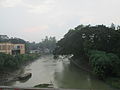 Bongshi River
 -
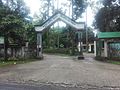 Main Gate of Madhupur Eco Park


Education[edit]
- Pirgacha Saint Pauls High School
- Gangair Ahammad Ali Memorial High School
- Courpus Christy Primary School and High School
- Madhupur Shahid Smrity Higher Secondary School
- Alokdia High School
- Madhupur College
- Madhupur Rani Bhabani Model High School
- Madhupur Bahumukhi Model Technical Institute
- Brahminbari High School
Notable residents[edit]
- Edric Baker, medical doctor, ran a low cost health clinic in the upazila from 1996 until his death in 2015.[6]
See Also[edit]
- Edric Baker, medical doctor, ran a low cost health clinic in the upazila from 1996 until his death in 2015.[6]
- Dokhala Forest Jame Mosque
- Jalchatra Bazaar, Bangladesh
- Madhupur, Bangladesh
- Upazilas of Bangladesh
- Districts of Bangladesh
- Divisions of Bangladesh
- Madhupur National Park,Deer Breeding Center,Tourist tower
References[edit]
- ^ Abedin, Joinal (2012). "Madhupur Upazila". In Islam, Sirajul; Jamal, Ahmed A. (eds.). Banglapedia: National Encyclopedia of Bangladesh (Second ed.). Asiatic Society of Bangladesh.
- ^ a b "Bangladesh Population and Housing Census 2011 Zila Report – Tangail" (PDF). bbs.gov.bd. Bangladesh Bureau of Statistics.
- ^ "Community Tables: Tangail district" (PDF). bbs.gov.bd. Bangladesh Bureau of Statistics. 2011.
- ^ "Pineapple growers demand processing centre in Madhupur". The Independent. Dhaka. July 22, 2015. Retrieved January 16, 2016.
- ^ a b "District Statistics 2011: Tangail" (PDF). Bangladesh Bureau of Statistics. Archived from the original (PDF) on 13 November 2014. Retrieved 14 July 2014.
- ^ a b Shakil, Mirza (2 September 2015). "Doctor for the poor no more". The Daily Star.
| Upazila/Thana: | ||
|---|---|---|
