List of World Heritage Sites in Namibia
 From Wikipedia the free encyclopedia


The United Nations Educational, Scientific and Cultural Organization (UNESCO) World Heritage Sites are places of importance to cultural or natural heritage as described in the UNESCO World Heritage Convention, established in 1972.[1] Namibia accepted the convention on April 6, 2000, making its historical sites eligible for inclusion on the list. As of 2023, there are two World Heritage Sites in Namibia.[2]
Location of sites[edit]

List of sites[edit]
| Name | Image | Location | Criteria | Year | Description |
|---|---|---|---|---|---|
| Twyfelfontein or /Ui-//aes |  | Kunene Region | Cultural (iii) (v) | 2007 | Twyfelfontein or /Ui-//aes has one of the largest concentrations of [...] petroglyphs, i.e. rock engravings in Africa. Most of these well-preserved engravings represent rhinoceros, . The site also includes six painteelephant, ostrich and giraffe, as well as drawings of human and animal footprintsd rock shelters with motifs of human figures in red ochre. The objects excavated from two sections, date from the Late Stone Age. The site forms a coherent, extensive and high-quality record of ritual practices relating to hunter-gatherer communities in this part of southern Africa over at least 2,000 years, and eloquently illustrates the links between the ritual and economic practices of hunter-gatherers.[3] |
| Namib Sand Sea | 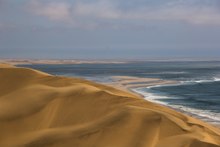 | Kunene Region, Erongo Region, Hardap Region, ǁKaras Region | Natural (vii) (viii) (ix) (x) | 2013 | Namib Sand Sea is the only coastal desert in the world that includes extensive dune fields influenced by fog. Covering an area of over three million hectares and a buffer zone of 899,500 hectares, the site is composed of two dune systems, an ancient semi-consolidated one overlain by a younger active one. The desert dunes are formed by the transportation of materials thousands of kilometres from the hinterland, that are carried by river, ocean current and wind. It features gravel plains, coastal flats, rocky hills, inselbergs within the sand sea, a coastal lagoon and ephemeral rivers, resulting in a landscape of exceptional beauty. Fog is the primary source of water in the site, accounting for a unique environment in which endemic invertebrates, reptiles and mammals adapt to an ever-changing variety of microhabitats and ecological niches.[4] |
Tentative List[edit]


.jpg)


References[edit]
- ^ "The World Heritage Convention". UNESCO. Retrieved 21 September 2010.
- ^ "Namibia". UNESCO. Retrieved November 20, 2023.
- ^ "Twyfelfontein or /Ui-//aes". UNESCO World Heritage Centre. Retrieved 2023-11-20.
 Text was copied from this source, which is available under a Creative Commons Attribution 3.0 IGO (CC BY 3.0 IGO) license.
 - ^ "Namib Sand Sea". UNESCO World Heritage Centre. Retrieved 2023-11-20. Text was copied from this source, which is available under a Creative Commons Attribution 3.0 IGO (CC BY 3.0 IGO) license.
- ^ "Brandberg National Monument Area". UNESCO World Heritage Centre. Retrieved 2021-11-20.
- ^ "Fishriver Canyon". UNESCO World Heritage Centre. Retrieved 2021-11-20.
- ^ "Welwitschia Plains". UNESCO World Heritage Centre. Retrieved 2021-11-20.
- ^ "Benguela Current Marine Ecosystem Sites". UNESCO World Heritage Centre. Retrieved 2021-11-20.
- ^ "Etosha Pan". UNESCO World Heritage Centre. Retrieved 2021-11-20.
- ^ "Sān Living Cultural Landscape". UNESCO World Heritage Centre. Retrieved 2021-11-20.
- ^ "Succulent Karoo Protected Areas". UNESCO World Heritage Centre. Retrieved 2021-11-20.
- ^ "Okavango Delta". UNESCO World Heritage Centre. Retrieved 2021-11-20.
| Locations | ||
|---|---|---|
| Related | ||