Koliri
 From Wikipedia the free encyclopedia
Koliri Κολίρι | |
|---|---|
 | |
 Koliri | |
| Coordinates: 37°41′15″N 21°28′25″E / 37.6874°N 21.4737°E | |
| Country | Greece |
| Administrative region | West Greece |
| Regional unit | Elis |
| Municipality | Pyrgos |
| Municipal unit | Pyrgos |
| Population (2021)[1] | |
| • Community | 787 |
| Time zone | UTC+2 (EET) |
| • Summer (DST) | UTC+3 (EEST) |


Koliri, (Greek: Κολίρι) is a village and a community in the municipality of Pyrgos, Elis, Greece. It is situated on a hillside, 3 km northeast of Pyrgos town centre and 3 km northwest of Varvasaina. The Greek National Road 74 (Tripoli – Olympia – Pyrgos) passes south of the village. The community includes the village Kolireikes Paragkes. It has two churches: the Church of Saint Nicholas and the Church of the Saints Theodore. Its elevation is 90 m. Koliri suffered damage from the fires of August 2007.[citation needed] Koliri has a football team called Anatoli (meaning Sunrise in Greek), which plays in the local championships.
Population[edit]
| Year | Village | Community |
|---|---|---|
| 1981 | – | 1,012 |
| 1991 | 815 | – |
| 2001 | 708 | 1,061 |
| 2011 | 621 | 979 |
| 2021 | 597 | 787 |
Gallery[edit]
-
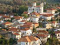 the center of the village along with Saint Theodoroi main church
 -
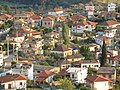 The centre
 -
 Interior of Saint Nicholas Church.
 -
 The forest after the fire
 -
 Small pine trees appeared after the fires of August 2007
 -
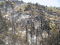 The forest after the fires
 -
 The forest before the fires
 -
 Overview of the village
 -
 The area of the village next to Saint Nicholas Church


See also[edit]
References[edit]
- ^ "Αποτελέσματα Απογραφής Πληθυσμού - Κατοικιών 2021, Μόνιμος Πληθυσμός κατά οικισμό" [Results of the 2021 Population - Housing Census, Permanent population by settlement] (in Greek). Hellenic Statistical Authority. 29 March 2024.
External links[edit]
This Western Greece location article is a stub. You can help Wikipedia by expanding it. |