Kilefjorden
 From Wikipedia the free encyclopedia
| Kilefjorden | |
|---|---|
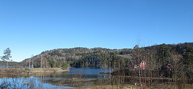
 View of the lake in Vennesla | |
 Kilefjorden  Kilefjorden | |
| Location | Aust |
| Coordinates | 58°26′03″N 07°48′31″E / 58.43417°N 7.80861°E |
| Primary inflows | River Otra |
| Primary outflows | River Otra |
| Catchment area | Otra |
| Basin countries | Norway |
| Max. length | 9.5 kilometres (5.9 mi) |
| Max. width | 0.5 to 1.5 km (0.31 to 0.93 mi) |
| Surface area | 7.22 km2 (2.79 sq mi) |
| Shore length1 | 65 kilometres (40 mi) |
| Surface elevation | 32 metres (105 ft) |
| References | NVE |
| 1 Shore length is not a well-defined measure. | |
Kilefjorden is a lake on in Agder county, Norway. The lake is located on the border of the municipalities of Evje og Hornnes, Iveland, and Vennesla. The lake is part of the river Otra. The lake is located about 6 kilometres (3.7 mi) west of the village of Birketveit in Iveland, about 2.5 kilometres (1.6 mi) north of the village of Hægeland in Vennesla, and about 15 kilometres (9.3 mi) south of the village of Hornnes in Evje og Hornnes.[1]
The steamship Bjoren worked in this lake from 1866–1896 transporting people and items across the lake. In 1896, the boat was moved to the Byglandsfjorden. The Norwegian National Road 9 runs along the southwestern end of the lake.
Prior to 1950, the lake's outflow was at the waterfall Soga on the southeast end of the lake. In 1950, the Gåseflå dam was built further upstream creating the lake Gåseflåfjorden which adjoins the Kilefjorden at the same surface elevation so the waterfall is now underwater and it can only be seen when the lake Gåseflå is lowered for work on the power station.[2][3]
Media gallery[edit]
-
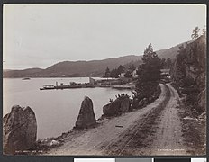
 View of the lake in the late 1800s
 -
 View of the lake in the late 1800s
 -
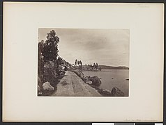 View of the lake between 1864 and 1889
 -
 View along the Rv9 highway


See also[edit]
References[edit]
- ^ "Kilefjorden" (in Norwegian). yr.no. Retrieved 2010-05-17.
- ^ "Soga" (in Norwegian). SetesdalsWiki. Retrieved 2017-01-17.
- ^ "Kilefjorden" (in Norwegian). SetesdalsWiki. Retrieved 2017-01-17.