Kerrykeel
 From Wikipedia the free encyclopedia
Kerrykeel An Cheathrú Chaol | |
|---|---|
Village | |
 | |
 Kerrykeel Location in Ireland | |
| Coordinates: 55°08′19″N 7°39′46″W / 55.138731°N 7.662792°W | |
| Country | Ireland |
| Province | Ulster |
| County | County Donegal |
| Government | |
| • Dáil Éireann | Donegal |
| Population | 355 |
| Area code(s) | 074, +353 74 |
| Irish Grid Reference | B847228 |
Kerrykeel (Irish: An Cheathrú Chaol, meaning "The Narrow Quarter";[2] historically and in census returns Carrowkeel) is a small village in County Donegal, Ireland. It lies between Knockalla Mountain[3] and Ranny Hill and is on the shores of Mulroy Bay.[4] Kerrykeel is accessible via the R245[5] and R247 roads which converge in the centre of the village. Kerrykeel is also in close to the tourist area of Portsalon. Portsalon serves as the gateway to the Fanad Peninsula.[citation needed]
Amenities[edit]
Amenities include Saint Colmcille primary school, a Garda station, Roman Catholic and Presbyterian churches, a post office, a grocery shop, butchers, and several takeaways and restaurants.[citation needed]
Every Saturday morning the Kerrykeel Country Market takes place.[6] During the summer period Kerrykeel sees an increase of tourists, with some staying in holiday rental homes in the area.[citation needed]
A 'Tidy Towns' committee was set up with the vision of improving the overall look of the village.[7] This has included the addition of seasonal flower beds, green areas along the roads leading into the village and improvements to the pier and lay-by along the Milford to Kerrykeel road.[citation needed]
In 2013, Kerrykeel was mistakenly named the 'Crime Capital Of Ireland' after a computer glitch at the Central Statistics Office. With a population of just over 400 people, Kerrykeel was said to have an increase in sexual assaults, burglaries and theft. Later the CSO stated that Kerrykeel was mixed up with Kevin Street. The error was later rectified.[8]
Gallery[edit]
-
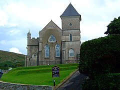
 Our Lady of Lourdes Roman Catholic church
 -
 Kerrykeel Garda station
 -
 The Presbyterian Church in Kerrykeel


Notable people[edit]
- Billy Gillespie, footballer, born Kerrykeel
- John Kerr, ballad singer
See also[edit]
References[edit]
- ^ "Census 2016 Sapmap Area: Settlements Carrowkeel". Central Statistics Office (Ireland). Retrieved 6 June 2018.
- ^ "An Cheathrú Chaol/Kerrykeel". Placenames Database of Ireland (logainm.ie). Department of Culture, Heritage and the Gaeltacht and Dublin City University. Retrieved 26 July 2020.
- ^ PATRICK ŻERKOWSKI (1 December 2014), KNOCKALLA MOUNTAIN, retrieved 22 June 2019
- ^ "DisplayPlace". www.discoverireland.com. Archived from the original on 16 September 2006.
- ^ "R246 · Co. Donegal, Ireland".
- ^ "Kerrykeel Country Market". www.facebook.com. Retrieved 22 June 2019.
- ^ "Kerrykeel Tidy Towns". www.facebook.com. Retrieved 22 June 2019.
- ^ "Donegal village accidently [sic] named 'crime black spot'". bbc.com. 25 September 2013. Retrieved 19 April 2019.
External links[edit]
![]() Media related to Kerrykeel at Wikimedia Commons
Media related to Kerrykeel at Wikimedia Commons
